

|
|
Route |
|---|---|
|
|
37.84100°N / 108.0006°W |
|
|
Mountaineering |
|
|
Summer, Fall |
|
|
A long day |
|
|
Class 3 (in ideal conditions) |
|
|
Overview
 El Diente North Slopes
This route is recommended as a snow climp up the central couloir on El Diente's broad north face. Most years, deep snow remains in the couloirs and gullies on the north slopes year around. 2007 was an exception. Prepare for steep, icy snow any time of year.
The route is best when there is more snow, such as early June.
Late in the season, August and September, this route becomes a bowling alley of loose rock and boulders, forcing climbers to scramble up the rock ribs between gullies to escape mortal danger. This route requires experience in snow and rock climbing, and sometimes, nerves of steel.
Round trip distances and elevation gain:
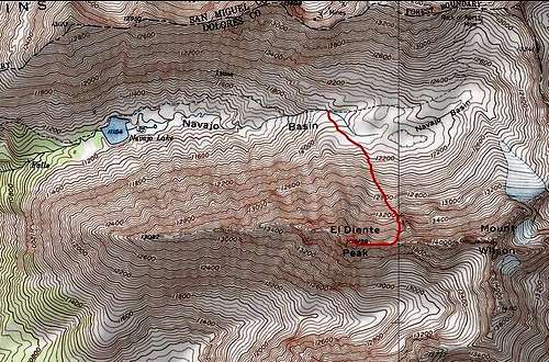 Route to the summit, from Navajo Basin.
A Dangerous Route!
Although this is possibly the standard route on El Diente, it is not a safe route. To emphasize the point, I have collected these excerpts from the El Diente climbing log entries on SummitPost. These pertain to the North Slopes Route:"Very loose and potentially dangerous mountain."
"This is a dangerous mountain!! Far worse then the Bells or Little Bear."
"Getting off this mountain is much tougher than getting up it."
"The descent off El Diente into Navajo Basin is loose and steep. Take this mountain seriously!"
"Approach this mountain with care."
"the closest I have come to death by lightning."
"hearing nightmares from others on the ridge who had climbed the north slopes"
"horror stories from climber's on the North Slopes"
"Very rotten at the top of the couloir...be very careful if their are climbers below you!"
"do not trust anything you step on or pull on here."
"north slopes route which is the loosest, most dangerous rock I have been on. I would highly recommend NOT descending this route!"
"I took a nasty fall, despite my crampons and axe. After immediately attemping self-arrest, which only slowed my progress on the 55 degree slope, due to the rotten snow conditions, I flipped onto my back when my crampons caught a rock hidding under the shallow snow. Immediately I returned into the arrest positon, finally coming to a stop after a 100 foot slide (and only ten feet above a ten foot drop onto rocks. Fortunately, my quick reactions and equipment prevented any injuries other than scraped knuckles and some soreness."
"My partner carefully downclimbed this section w/o incident, although he was shaken to watch my accident."
"do not take them lightly...they are difficult climbs with dangerous potential, even if the weather is perfect"
"a miserable route"
"Don't take this mountain lightly at all!"
"miserable route"
"Another group on the mountain had a miserable + dangerous descent of this route - be careful."
I have read of at least six fatalities on El Diente and there have probably been many more than that. A partial list may be found here.
Approach
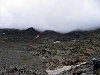 Aim for the base of the couloir
The north face may be approached from either end of the Navajo Basin.
1) Silver Pick Trailhead to Rock of Ages Pass, and down into the upper end of Navajo Basin. This approach is now closed, pending a settlement with land owner.
2) Use the Navajo Lake Trailhead to reach Navajo Lake and the lower end of the basin.
Hike south from the central part of Navajo Basin toward El Diente's north face, directly underneath the summit. Aim for rock/snow apron at the base of the north face's main couloir.
Route Description
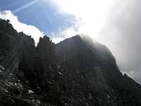
 Steep as it looks
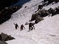
There are variations on this route. It is a long, grueling climb no matter how you do it. If you can find a pleasant way up through all the crags, rubble, dead ends, and bowling alleys, you are a mountaineering genius. The standard route ascends the main couloir a quarter mile east of the summit.
The snow steepness is moderate at first, but the difficulties and exposure increase further up. The upper half of the couloir becomes steeper and may be easiest to climb with good snow. Without snow, rockfall danger is high in the couloir.
 I can see the summit!
Hike up Difficult Class 2 terrain to reach the open area below the couloir. Above 12,500’, the location of the couloir should be obvious. Continue climbing to 13,000’, where you will enter the couloir. The couloir steepens as the rock-fall danger increases proportionally. A helmet is essential, although it won't do much to slow down the boulders. In snow, crampons are strongly recommended.
Continue climbing to the top of the couloir, which ends at a large headwall at about 13,600’. Leave the couloir by scrambling up a rock/snow ramp on your right at the end of the couloir. This ramp leads to the summit ridge.
Lots of snow on north slopeAt you approach a small saddle on the ridge crest, you can see the summit off to the west. You are just east of the notorious Organ Pipes. Cross to the south side of the ridge. The rest of the route over to El Diente is marked with cairns. Climb west toward the summit below the ridge crest on the south side just below the Organ Pipes (class 3). Continue toward the base of a small slot, gully, or chimney as some describe it, on your right.
Climb back to the ridge crest via this gully. The gully has some loose rock and dirt, but it’s not too steep. Reach the top of the gully at a notch in the ridge, cross to the other side of the ridge, and climb to El Dientes’s summit on the ridge’s north side. This completes your serpentine route to the summit.
Essential Gear
[img:419156:alignleft:small:Lots of snow on north slope]1) Helmet
2) Ice ax. This route involves long stretches of steep snow, any time of year. Even in August, a majority of this route up through the gullies is deep, steep snow.
3) Crampons
External Links
Hiking In the Rockies (with many great photos)Route description by Bill Middlebrook, and photos on 14ers.com
DistantPeak trip report