|
|
Route |
|---|---|
|
|
42.50000°N / 122.1°W |
|
|
A winter snowshoe or nordic ski route. |
|
|
One to two days |
|
|
A steep cross-country or snowshoe ascent. |
|
|
Approach
Access from the Westside Road starts from Malone Spring and follows old logging roads and trails up the east flank to the summit, although these are no longer shown on Forest Service maps. In the winter it takes about two days because most of the access roads are snowed in, meaning that you have to park at a lower elevation and farther away, adding several miles to the trip.
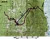 |
Route Description
Ascend straight up the mountain just to the north of the Northeast Ridge route. It is fairly easy until you get to Lake Francis, at the very bottom of the glacial cirque. Ascend to the west, up the steep headwall, to the summit. If you bring a snowboard or skiis, the northeast cirques are an intermediate downhill ski run. It is 11 miles round-trip. The elevation gain for this route is about 3800 feet.
Essential Gear
In the winter, bring snowshoes or nordic skiis (Pelican Butte gets a lot of snow). Also, bring maps, food, water, and survival gear (you are likely to be the only person or group on the mountain in the winter). In the summer, bring lots of water, food, and maps. Wear sturdy hiking boots in the summer and early fall. For winter you also should use a backpack, because it is usually a two-day ascent.
Miscellaneous Info
If you have information about this route that doesn't pertain to any of the other sections, please add it here.