
-
 4229 Hits
-
 74% Score
-
 4 Votes
|
|
Route |
|---|---|
|
|
29.15750°N / 103.2677°W |
|
|
Hike/Scramble/Semi-Technical Climbing |
|
|
Most of a day |
|
|
High 4th Class, extended 3rd Class |
|
|
Approach
To get to the Elephant Tusk trailhead, follow the description on the main page.
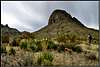
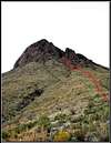
Route Description
From the trailhead, follow the faint trail in a general northwest direction. This trail is very poorly marked in some spots, and wanders in great bends, so take great care in following the many cairns that are in place. Follow this trail for nearly 4 miles, it will lead very near to the base of the peak. After you enter a long sandy creek, much longer than the ones before, begin to scramble to your left (south) and uphill towards the base of the peak. The sooner you make this move the better, as a large gully separates you and your goal, and only gets steeper the further you travel along it. After emerging from this gully, make your way as best as possible towards the northern base of the peak, directly below the east facing notch that is clearly visible. After several hundred feet of avoiding the abundant Lechugilla, you will begin your scree slope ascent. Try and travel on the larger rocks, as they are less likely to slide, and will make your ascent more of a scramble than a battle. Continue climbing this scree up into the gap, until you reach a narrow spire at the very top. This next 30 foot section is the crux of the ascent. Be very aware of loose rocks the rest of the ascent, the Rhyolite fractures and large chunks willingly free themselves at the most inopportune moments. Gerry Roach's route description advises going to the right, but the crack that direction is filled with thick thorns and other miscellaneous pokers, so an ascent up the left notch, though a little bit tougher, is less abusive on your body. Once you have reached to top of the crux, head up and to your left, continuing up the sustained 3rd class climbing until you reach the summit ridge, and then follow that ridge to the top. Be aware of small cacti, scorpions, and centipedes that love to inhabit the hand holds of this climb. An injury a this stage could be very bad. Round trip is around 10.5 miles with ~2700 feet of elevation gain, 2,300 of that on the mountain itself.
 |  |  |  |  |
Essential Gear
Water. Lots of it. 4-5L should be enough in cool weather, the hotter it gets the more you'll need. Rope isn't necessary, but if you like that comfort piece, then bring enough for the 30 foot crux. A climbing helmet is recommended, the Rhyolite is very unstable.
Miscellaneous Info
If you have information about this route that doesn't pertain to any of the other sections, please add it here.