
-
 9997 Hits
-
 79.04% Score
-
 10 Votes
|
|
Route |
|---|---|
|
|
35.96950°N / 105.6439°W |
|
|
Hiking, Mountaineering, Scrambling |
|
|
Spring, Summer, Fall, Winter |
|
|
Half a day |
|
|
Class 2 with short Class 3 section |
|
|
Route Description
Route Start: "Medio" Truchas Peak summit (13,060 ft.) or Lower saddle between North and "Medio" Truchas Peaks (~12,400 ft.)Distance/Elev. Gain(Saddle-"Medio" Truchas Peak summit): 0.6 mi/700 ft.
The Northeast Ridge of "Medio" Truchas Peak provides expedient way to climb "Medio"/Middle Truchas Peaks and South Truchas Peak from the upper Rio Quemado Basin or Truchas Lakes area. The upper Rio Quemado Basin can be approached from Rio Quemado Trailhead via Rio Quemado Trail (Trail #153). Truchas Lakes area can be approached from the upper Pecos River Valley trailheads via Skyline Trail (Trail #251), Beatty's Trail (Trail #25) or Jack's Creek Trail (Trail #257) or from Santa Barbara Trailhead via Trails #24/#25.
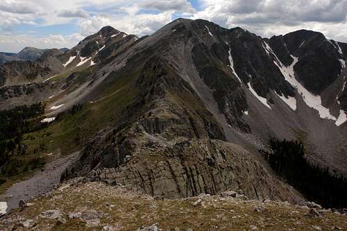
 NE Ridge Route from below the summit of "Medio" Truchas Peak NE Ridge Route from below the summit of "Medio" Truchas Peak |
 NE Ridge Route from North Truchas Peak NE Ridge Route from North Truchas Peak |
|---|
The route description here is from south to north ("Medio" Truchas summit-to-saddle). From the summit of "Medio" Truchas descend several hundred feet on the Class 2 terrain to the deep notch in the ridge. Scramble down into and out of the notch requires occasional Class 3 moves on a reasonably solid rock with some exposure. After the notch, its Class 2 terrain all the way to the "Medio"-North Truchas Saddle at 12,400 ft.
The "Medio"-North Truchas Saddle can be approached from the upper Rio Quemado Basin (west) or Truchas Lakes Basin (east) via parts of the Rio Quemado Trail (Trail #153) ascending the scree and talus slopes on the eastern and western sides of the ridge.
 Descending the upper part of NE ridge Descending the upper part of NE ridge |
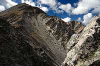
 Approaching the notch in the NE Ridge Approaching the notch in the NE Ridge |
 The closeup view of the northern side of the notch The closeup view of the northern side of the notch |
 Scrambling inside the notch Scrambling inside the notch |
 Medio and Middle Truchas Peaks from the notch Medio and Middle Truchas Peaks from the notch |
|---|
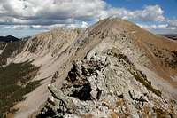 The lower NE Ridge The lower NE Ridge |
 Traversing the lower NE Ridge Traversing the lower NE Ridge |
 "Medio"-North Truchas Saddle, view west "Medio"-North Truchas Saddle, view west |
|---|