
|
|
Route |
|---|---|
|
|
38.84040°N / 105.1045°W |
|
|
Hiking, Scrambling |
|
|
Spring, Summer, Fall, Winter |
|
|
Half a day |
|
|
Class 3 |
|
|
Class 3 |
|
|
Approach
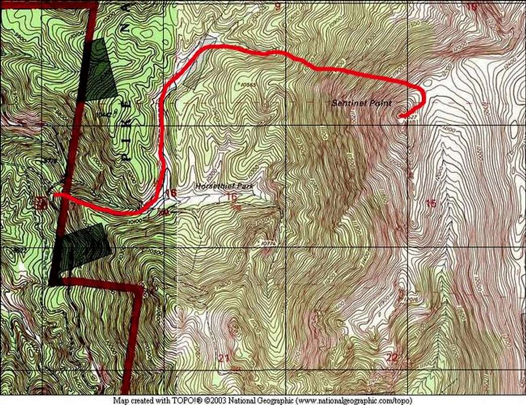
Midland Terminal Railroad Tunnel Trailhead 9,800 feetFrom the town of Divide, located on US 24 up Ute Pass from Colorado Springs, drive to the only stoplight in Divide. Turn south on HWY 67S, and drive 9.5 miles on this road until you come to a closed railroad tunnel (The Midland Terminal Railroad Tunnel). Slow down, and park shortly on the other side of the closed railroad tunnel in a large, paved parking area. There is overflow parking on the other side of the road.
Route Description

Begin at the Midland Terminal Railroad Tunnel Trailhead. From parking, get on the widely-used and easy to follow trail. The trail will switch back a few times, and then climb up to Horsethief Park next to a creek. Soon, you will come to a clearing. At this clearing, the trail forks. Take the left (north) fork and ford a small stream.
After crossing the stream, you will soon find a single track trail that goes over flat land in a small creek drainage. At the end of the drainage, there are several beaver ponds. This trail will fork. You want to take the northeastern fork and skirt the beaver ponds. Take a good look at Sentinel Point. This is the last time you will see it for quite a while.
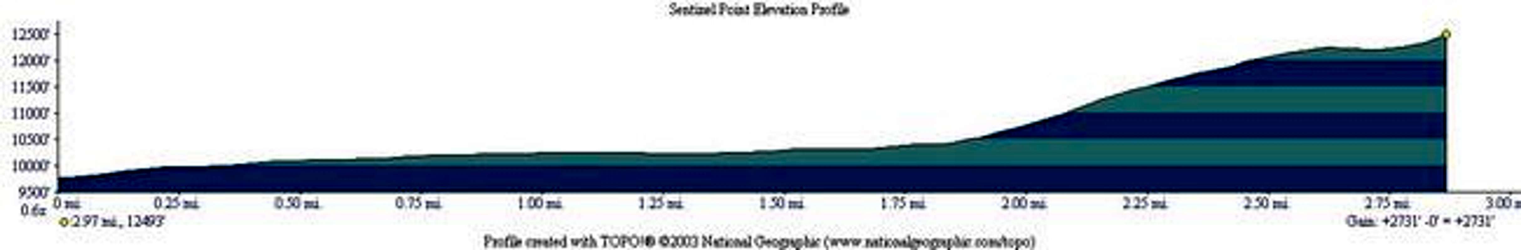
Enter dense forest on a good trail. Ensure that you are on a trail adjacent to a small creek. This is key. As you can see from the Elevation Profile below, most of the climbing is ahead of you. This trail climbs steeply up through the forest, and becomes fainter and fainter as you progress. There are several cairns along the trail. Follow the trail, and carefully look for cairns. If you are still next to the creek, you are going the right way.
At the top of this drainage, the creek leads you to a gigantic boulder field. Cairns here will lead you the wrong way! Do not enter the boulder field. Instead, countour around the north (climber's left) side of the field on grassy land, and climb higher. The top of this drainage should be apparent. You will not go all the way to the top.
Look closely to the east. You should see a large point (12,243 feet). You want to head for the saddle between this point and Sentinel Point. Sentinel Point will not be in view yet. Use your map and compass. When it looks right, cross the boulder field and climb up grassy and rocky slopes adjacent to a small forest area. Gain the saddle.
From this saddle, Sentinel Point's rocky summit will loom over you. Don't worry, it's not as hard as it looks.
Contour around a small bump in the ridge to the east, and approach the eastern side of the summit. This is where the route finding skills will come into play. Look at this photo.
Look very carefully for some cairns on large boulders. You want to climb up the center of the eastern side of Sentinel Point to reach the summit. Once you locate the cairns, climb straight up and follow them until you reach the Class 3 climbing. Look carefully for an old wooden sign (this might be gone at any time). This marks the easiest way to the summit. Study this photo, and notice the wooden sign.
Scramble up this gully in the boulders to the summit. Getting to the summit from here requires 200 feet of Class 3 scrambling. The precarious looking boulders are stable, but they all have very large gaps between them. Several moves will require you to bridge 3-4 foot gaps in the boulders with a 30 foot fall between your legs. Take your time here and make sure you are on the easiest route. Going the wrong way will require Class 5 climbing. If you think it's too hard, retreat and find the easy way.
The summit boulders of Sentinel Point are a great place to lounge and enjoy your hard-earned perch. Take in the views of several of Colorado's major ranges.
Round Trip Mileage: 6 miles
Elevation Gain: 2,800 feet
 |  |  |  |  |
Essential Gear
Standard hiking gear is fine in the summer. A helmet might be a good idea for inexperienced climbers for the final summit push.A map and compass are essential for this route. Much of the route follows faint trails in dense forest. There are countless social trails in this area that will throw you off. Ensure you are competent with your map and compass.
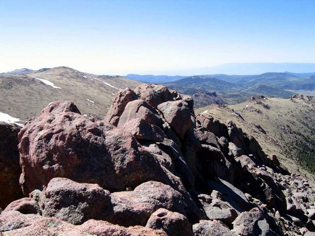
Summit Boulders of Sentinel Point