
|
|
Route |
|---|---|
|
|
40.37670°N / 105.7486°W |
|
|
bushwhack |
|
|
A long day |
|
|
class 3 |
|
|
Approach
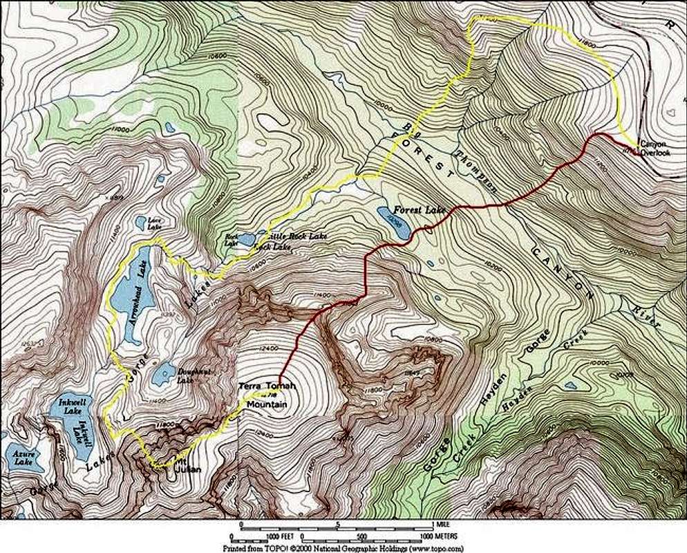
I don’t recommend this route for anyone that lacks extensive experience navigating through trees and shapeless terrain.
Here are three objectives:
1-drop 2000-ft into Forest Canyon.
2-Cross the Big Thomson River and make your way to Forest Lake at 10,298.
3-Locate East Ridge Route on Terra Tomah Mountain and ascend 2,800-ft to the summit.
Round Trip-5.6 miles and 4,674-ft (include Mount Julian add 1.6 mile & 478 ft)
From Forest Canyon Overlook, immediately locate the east ridge of Terra Tomah Mountain. It’s the ridge that reaches the summit plateau on the right. This is also a good place to scout the route from high above and locate some landmarks to simplify the hike through the dense forest of Forest Canyon. The order of the day is a 2,000 ft descent into the Canyon followed by a 3,000 ft ascent of Terra Tomah on the other side.
(per Jon Bradford with embellishments from Kane)
From the parking lot descend west then south down into the abyss of Forest Canyon. This steep bushwhack is not that difficult on the descent. On the exit it can be a sleeping dragon. When you finally reach the canyon floor one mile in, cross the famous Big Thompson River and begin the tedious trudge up through the dense trees to Forest Lake.
Route Description
From this placid location the route continues up the remaining timbered slopes to timberline on the increasingly defined northeast ridge of Terra Tomah Mountain. Expect class 3 scrambling on a brief portion of this ridge. The scenery along this drawbridge to the summit plateau is fantastic.
Once on the massive upper slopes of Terra Tomah Mountain, continue another half mile and 520-ft of vertical to the summit. This plateau is so expansive, it may be difficult to locate the actual summit. When you spot Mount Julian’s higher summit of to the west, keep hiking towards it and you will find Terra Toma’s summit on a stack of boulders out in the middle of nowhere.
From Terrah Tomah’s summit, continue on alpine tundra west towards the more defined summit of Mount Julian. The route from here is a scenic hike along a ridge that allows many chances to peer down into the secretive confines of the Gorge Lakes just to the north. Once on Julian’s summit enjoy the stellar view and solitude. There is a summit register placed September 9, 2004. The descent reverses the route or picks up the Gorge Lakes Route for a descent directly into the upper Gorge Lakes drainage. In either case the route out requires a 2,000 ft. ascent of the walls of Forest Canyon back up to your car.
Gorge Lakes
(per Jon Bradford with embellishments from Kane)
First, do not attempt the following descent of Mount Julian’s northwest face if there is any evidence of snow or ice. It will not go if there is snow or ice
The Gorge Lakes Route on Mount Julian is one of the most difficult stretches of terrain I have ever encountered. It is a bushwhack of unnerving intensity. I only descended it so I will describe it as such. I assume no one will want to actually follow this route so my description might wax heavy on emotional outpouring and lack in technical detail.
Begin on the summit of Mount Julian. From the summit cairn walk north 25 feet and stare down into the abyss of the Gorge Lakes drainage. From here you can see all the Gorge Lakes except Rock and Forest. Immediately start descending down a ledge-ridden broad gully that runs right up to the summit. The trickiest move is up top. Looking down the gully is quite manageable with the biggest concern being unseen cliffs. Fortunately near the bottom this gully reaches easy broken slopes between two adjacent cliff bands. If wet this gully would be awful. In dry conditions it is fun. Kane discovered this nifty descent so I refer to it as Cain Coulior.
From the bottom of the gully, it is a pleasant stroll to a glacial bench overlooking Inkwell Lake. From here to the north end of Arrowhead Lake the route is an absolute joy. This is a wonderful, pristine glacial basin. There was no sign of people here. None. The lakes are magical, the scenery spectacular, and it is in one of Colorado’s most visited mountain locations, RMNP. Yet this basin is as pristine as Colorado's mountains may allow... And the reason for this is the basin below Arrowhead Lake is ghastly. That is not to say that it isn't beautiful in a primeval, terrible sort of way. It starts out with the descent of one of the more obnoxious headwalls choked in steep timber and riddled with little cliff bands. To get out of this you can climb into the gorge-like little creek bed that offers slick rocks choked with willows. As one nears the ledges and flats of the headwall one realizes that these aren't meadows but willow-choked bogs. Retreat back to the trees and find boulder and deadfall littered slopes that contain many hidden mini-cliffs. At the lower basin it is possible to escape this cacophony of misery on a tipsy boulder field. On Kane and I's descent the final insult came when, trying to bypass a lower headwall we were descending a gully that was blocked by a large chalkstone. Climbing over it would have been dangerous. We could squeeze under it with a little contortion... and that is what we did. This route has it all... From the vicinity of the Rock Lakes conditions improve dramatically (which is a good thing otherwise one might start searching for the emergency cyanide tablets).
The walk along the faint fishing trails below Little Rock Lake is a nice salve to the hurts garnished upstream. Soon however it is time to again bushwhack through dense trees and deadfall to reach the low point of the Big Thompson River. From here there is no way to go but up so begin the 2,000 ft climb to the car. By now you should be numb to heartbreaking bushwhack but this ascent is painful even so.
Essential Gear
compass/GPS/Topo map
desainme - Oct 24, 2004 3:11 pm - Hasn't voted
Route CommentOn Kane's and my descent, or how about On our descent,
Interesting write up anyway.