
|
|
Route |
|---|---|
|
|
39.43100°N / 106.1051°W |
|
|
Ridge Scramble |
|
|
Half a day |
|
|
Class 3 |
|
|
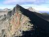
Northeast Ridge Overview
This has got to be one of the best kept secrets in the Ten Mile/Mosquito range. The Northeast Ridge route is a true ridge route as it follows the narrow exposed ridge crest for nearly 1000 ft to the summit. Unlike other "ridge" routes in the range, this one is not only a true ridge, it is also made up of solid rock that is perfect for scrambling.
I'd highly recommend this route for anyone looking to make the step into a more hands on approach to climbing Colorado's High Peaks. Route finding is straight forward and the actual climbing on this route is just enough to make it interesting while keeping the commitment level manageble.
 |  |
Approach
This climb starts from the Spruce Creek TH. See the main page for directions to this point.
From the winter (2wd) parking area, follow the 4x4 road for a few hundred yards where a spur road (Crystal Creek Road) starts to climb steeply to the right. Follow the Crystal Creek Road for about 1.4 miles until you reach treeline at about 11,400 ft. There are several other trails and roads that intersect in this area but the main 4x4 road continues straight ahead as it climbs the valley towards Lower Crystal Lake.
You will start to see the surrounding peaks, including Mount Helen and Peak 10 as you contiue up the valley. Continue to follow the main road as you will finally reach Lower Crystal Lake. Father Dyer Peak is immediately noticable to the West and it's rugged NE Ridge comes into full view. At this point a lesser road branches to the right while the main road makes a turn to the SW as it continues to climb. When the road finally makes a sharp switchback to the left, you will leave it at this point and make for the grass slopes at the lower end of the Northeast Ridge.
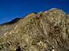
The Northern side of the ridge is very steep and doesn't provide suitable access. Instead, follow the grass slopes around and up on the Southern side of the Ridge until you can easily gain the ridge.
Now for the fun part!!
 |
Route Description
At about 2.8 miles and 12, 700 ft you will gain the ridge, the routefinding is over and the fun is about to begin. The route stays on the ridge crest the entire way to the summit. The ridge is very narrow and exposed in spots but the difficulty never exceeds Class 3 and the rock is excellent for this range of mountains.
Continue up the crest of the ridge until you reach the summit ridge at about 13,580 ft. From here you can see the true summit to the SW. From here it is an easy, but exposed ridge to the top.
 |  |
Essential Gear
Standard summer gear. Sturdy shoes or boots with good traction.
Winter will most likely require either snowshoes or skis as well as an axe.