
|
|
Route |
|---|---|
|
|
43.66990°N / 114.6798°W |
|
|
Bushwhack/Scramble |
|
|
Half a day |
|
|
Class II |
|
|
Approach
To access the Northeast Ridge Route from Ketchum, Idaho, drive north on Highway 75 for 16 miles until reaching the turnoff on the south side of the highway for Baker Creek.
Take this turn and follow this outstanding dirt road for 9.5 long miles to the depth of the Smoky Mountains. Park at the trailhead for Baker Lake.
Route Description
Route Stats
From the trailhead, hike less than one-quarter mile up the Baker Lake trail until reaching the point where it turns noticeably northwestward. At this point, leave the trail and cross to the south side of Baker Creek, which may be difficult early in the season.
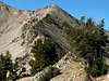
Bushwhack through the steep, forested slopes to the saddle that sits just above 8,600'. Turn west and follow the gradual rising northeast ridge of Baker Peak for a little more than a mile to the false summit just to the north of the peak. The ridgeline is made of mostly broken rock but no climbing is required.
From the false summit, follow the obvious ridgeline to the summit area to the south.
 |
Essential Gear
No essential gear required for this relatively easy route up Baker Peak.
Miscellaneous Info
If you have information about this route that doesn't pertain to any of the other sections, please add it here.