
|
|
Route |
|---|---|
|
|
33.97020°N / 115.0728°W |
|
|
Hiking |
|
|
Spring, Fall, Winter |
|
|
Most of a day |
|
|
Class 2 |
|
|
Overview
If like me, you’re looking to hike Granite Peak and don’t want to deal with the long 4WD-only roads to the southern approaches, this route provides an alternative. While a 4WD would still be required to drive the roads here, the 4WD portion is much shorter – short enough to where it could be walked or mountain biked and only a passenger car would be required for the drive. I used a mountain bike, and it worked out nicely. For lack of a better name, I’ll call this route the northeast ridges.
Getting There
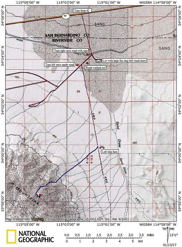
From the junction of highways 62 and 177, drive approximately 11.2 miles east on the 62, and look for an unsigned well-groomed dirt route heading south (this junction is located at: 34.09557°N, 115.03927°W). Continue south on this dirt road for just under 2 miles. The road is in excellent shape and can be driven by most passenger cars - presumably groomed for servicing the aqueduct. Along the way, you should see a sign mentioning something about the road being private, but open for public use. After just under 2 miles, you’ll come to a 4-way junction – continue straight. You’ll be crossing over the aqueduct, which is underground here.
If you have 4WD high-clearance: Shortly after the 4-way junction (less than 1/4 mile) angle right onto a secondary dirt road and note your odometer. You'll know you're on the correct road here by two things - there is a south-facing sign at the turnoff (same as the sign on the way in - something about a private road that's open for public use), and second, you'll cross a wide wash almost immediately. Continue on this road, crossing a 2nd and 3rd wash. At the 3rd wash, the road is heavily damaged, and high clearance/4WD will be needed. After 2/3rds of a mile from the main dirt road, turn left (south) at a junction. Continue on this road, sometimes sandy, approximately 4.2 miles and park.
If you do not have 4WD high-clearance: After the 4-way junction, continue on the main road about ¼ mile to a lot on the left with a large fire ring. Park here. The lot sits about 5 feet below the road and a passenger car might have problems getting into it, but there is ample parking without obstacles just beyond the lot. Walk or mountain bike the above 4WD directions. This adds approximately 5 mile each way with just a few hundred feet of elevation gain. I was able to bike ~85% of this, walking the washes and sandier portions of road, and taking less than an hour each way. Spare tubes/tools would be advised for bikers.
See this map to visualize the driving approach.
Route Description
On your way in, try to identify the largest canyon coming down from Granite that opens up towards the northeast. The northeast ridges route starts in the next major canyon to the left. From the road, hike southwest across easy desert terrain 2.5 miles to the mouth of this canyon, crossing the occasional wash along the way.
Enter the canyon and continue ~1/4 mile, exiting up and to your right up a steep yet easy class 2 slope to gain the ridge. This should put you at an obvious large and bare flat spot on the ridge. From here, the goal is to get into the prominent wash west of this flat spot. Continue southwest up the ridge towards Granite a short ways, leaving the crest of the ridge to your right before you start working through piles of rock. Traverse several hundred feet until you reach an easy class 2 chute leading to the sandy wash below, and follow it down, dropping 100-150 feet. Do not attempt to drop into the wash before you see the obvious route to get down to it, otherwise you will cliff out (this is fairly evident from above).
Follow the wash west just a few hundred feet, and exit right up an obvious narrow chute. It would be best if you can identify this chute before you drop into the wash – there are two main chutes here – the one you’re looking for is further to the west, is less steep, and is choked with a few yuccas about 2/3rds of the way up. Hike up this chute until you gain the ridge. Once you gain the ridge, it’s an easy walk the rest of the way. Continue southwest towards the main crest, then follow the crest to Granite’s summit.
See the route overlay and this map to help visualize the route.
Stats (from 4WD parking): 9 miles roundtrip, 3400’ gain/loss
If you walk or bike the 4WD road, add 10 miles and 200’ gain/loss roundtrip
Alternatively - it may be possible to continue more directly to Granite from the "flat spot" mentioned above. I started up this way in low visibility, and scrambled through 2 rocky sections on the ridge, the second being easy class 3. I was able to see a 3rd section that looked to be more challenging, but I couldn't see what was beyond, so I turned back and took the easier route. Once the clouds cleared, from what I could see, that 3rd section may have been the last obstacle on the more direct route. I marked this possible route on the overlay. Certainly there are many other route possibilities.
Essential Gear
Water (none available on the route)