
-
 8810 Hits
-
 86.77% Score
-
 23 Votes
|
|
Route |
|---|---|
|
|
51.86716°N / 116.92955°W |
|
|
Mountaineering |
|
|
Summer |
|
|
A few days |
|
|
III |
|
|
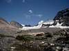
Overview/Approach
Mount Forbes is the highest peak in Banff National Park (11,850') and the northwest face variation, first claimed as an FA in 1971, is becoming a classic venture deep into the Canadian Rockies. The face climbing is at a 40-50 degree angle on either snow (early season) or ice (late season) and crosses the bergschrund about a fourth of the way up the face. Most, including myself, recommend climbing the face in early season more to take advantage of the snow bridges across the heavily crevassed middle section of the Forbes north glacier approach than for the ease of climbing the north face itself.


The effort it takes to surmount Mount Forbes is most infamous for its one to two day approach from the Icefields Parkway at the Saskatchewan River Crossing which sits at approximately 4500’. Mount Forbes’ summit sits at approximately 11,850’. As the crow flies, it is only 11 miles from the Saskatchewan River crossing to the summit of Mount Forbes. As a man walks however, it is a serious hump and bushwhack through incredibly wild and scenic backcountry. There is an alternative approach via relatively new logging roads to the south of the mountain, but this approach would cause one to miss out on the adventure and wilderness of climbing Mount Forbes not to mention these roads are not 100% reliable. Much of the rough “here again, gone again trail” from the Icefields Parkway no doubt is more commonly used by grizzly bears (versus man) who populate this pristine glacier valley covered with berry bushes. One passes through so many ripe berry bushes in August that you no doubt smell like one large berry at the end of the day. Once you wade through mosquito infested swamps, cross the icy cold glacier river, bushwhack up through the grizzly prone slopes, advance past the headwall, route find your way through a myriad of snow bridged crevasses on Forbes' north glacier, the north face will seem quite the pleasure to climb.
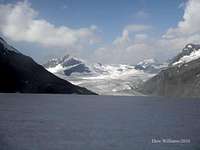
Drive west of Lake Louise approximately 76km on the Icefields Parkway and park on the left at the Glacier Lake trailhead (approximately 150km south of Jasper). Hike in approximately 9km on the up and down well maintained trail to Glacier Lake crossing the Saskatchewan River via a pristine bridge. Unfortunately you gain little elevation by ascending from the river and then descending to the lake. There is a formal campground established at the south end of the lake. Continue along a decent single track trail on the west side of Glacier Lake. You will have beautiful reflections of Division Mountain in the lake along with a hanging wall of ice off of the Lyell Icefield. On return, don’t forget to sit down at the south end of Glacier Lake, if in the evening, and enjoy the Loons. As you reach the other end of the lake (4kms+/-) the trail is no longer maintained (2010). The braided glacier melt river that feeds the lake creates a rough marsh like environment that would be difficult to maintain a trail for any period of time. At times you are walking through the marsh, where mosquitoes are abundant. At other times, you are better off fighting your way through downed trees up on the west bank. Either way, the trail finding and passage can be somewhat tedious to say the least. There are numerous grizzly bears who consider this their home range when berries are ripe. We saw tons of scat and fresh prints belonging to several different grizzlies as well as cub prints in August, 2010.
Once you get to where the drainage from the Mons Glacier intersects the drainage from the Lyell Icefield, you need to cross the river. In August, 2010, it was short of waste deep. If you cross even with the Mons Glacier drainage on the east side, you will find the most braided and shallow sections to cross. Once at the other end (where we found evidence of grizzly cubs), bushwhack up the bushy slopes to the right of the Mons Glacier drainage. Stay into the bush until a faint animal trail leads you onto a ridge. Follow this ridge south until you must descend to catch a shale ridden left shoulder high above the west side of the Mons Glacier drainage. Continue above tree line to alpine meadows.
Cross the meadows to an obvious break in the right side of the massive headwall below the Mons Glacier. This headwall is comprised of some of the more interesting rock formations you will find in the Canadian Rockies. Proceed up the break right to left following cairns that lead you through a few interesting fifth class steps, one of which is a perfect slide formed by waterfalls of years past. Continue to the top of the headwall and turn left following ledges above the large and loud glacier river until you can cross same via a huge gravel bed. Ascend pleasant rock steps up the other side keeping a due south heading. Be careful through this section in terms of black glacier ice (Mons Glacier) underneath this moraine ground. With your alpine axe, cross the moraine to the east wherever it gives you the best option. Some might opt for their crampons on this section. Get to the top of the moraine on the east side. Once you gain the east side of the moraine, Mount Forbes’ north face will start to come into view. Follow cairns up the Mount Forbes glacier drainage to the toe of the glacier below the north face of Mount Forbes. Continue up interesting huge slab thrusts to the toe of the glacier where you will have running water. I advise setting up a bivy below a significant wall to the south at the small glacier lake outlet that protects the bivy from the cold coming off of the glacier, but also has a small wall to the north toning down much of the noise caused by the outlet where there is of course easy access to running water.
Route Description
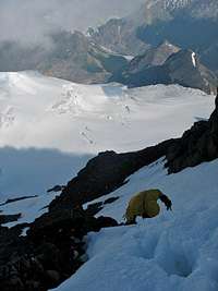
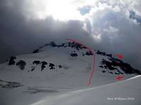
This is an 8000'+ accumulated ascent trip.In 2010, the best glacier access was on the right side of the toe. Climb up rocky ledges on the right until you can traverse left for easy access to the glacier. Traverse the ice up and left to access the center line avoiding the larger crevasses on either side. Wind your way up the north glacier. There are a few snow bridges, but one significant one will appear about half way to the base of the North face. If this snow bridge is gone, you might be faced with climbing in and out of this wide crevasse that appears to run the width of the glacier, to gain further access. Once near the base of the north face in line with rock gargoyles on your left, start up the steeper 40-50 degree face in a southwesterly direction taking on the relatively narrow bergschrund about a quarter of the way up. From the bergschrund, head straight up, circumventing any rock to the right until you meet up with the west ridge. Stay left as much as the rock bands allow thus taking advantage of the steep snow and ice. Eventually you will hit the west ridge proper which typically would have enough snow, verglas and cornices covering loose shale to allow you to keep your crampons on for the scramble to the summit. There is one rappel along the ridge covering one short section of snow and ice. There was no summit register or cairn as of 2010. Beware of the summit cornice.
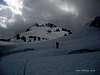
Climbing Sequence
 |
 |
 |
 |
 |
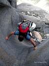
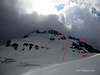
Climbing Sequence II
 |
 |
 |
 |
 |
Descent
Descend down the west ridge which will be a lot safer than descending the north face above the bergschrund. You start off on several steep snow slopes that allow you to descend some rapid ground. But in August you can count on running into quite a bit of soft scree as well. Eventually you get cliffed out at a wet gully. Ignore the rap stations to the right and continue along the right edge of the gully where you can down climb a few 5th class loose steps back into the gully on the left. There is a short rap for the second down climbing section if you want to use it (2010). Once down into the gully, descend easy ground to the west ridge col. Descend the glacier back to your packs at the base of the north face and return from there.Essential Gear
We used a 30m half rope. But if you think you might not be comfortable down climbing 5th class ground on the west ridge, then you will want a 60m rope for several rap options. All glacier gear including your crevasse extraction kit. A selection of ice screws and/or pickets depending on when you are climbing the northwest face. We climbed the northwest face in early August and set no pro, essentially soloing the route. This is a north face, so dress accordingly. Water is plentiful along the entire approach and route.External Links
100’s of Banff National Park multi-pitch rock climbs, ice climbs, alpine climbs and scrambles, just scroll down to routesBanff National Park, Parks Canada
Best Eats in Canmore: Rocky Mountain Flatbread Company, all organic fare, not just a pizza place, but a true best of the best mountain local dining experience, great on site owner and customer service with a smile, not easily obtained in Canmore
Best Eats in Banff: The Bison, all organic/free range fare, with a detailed description of their suppliers. Recently expanded (2010), I recommend sticking with the downstairs. Better menu, prices and social ambience. Maybe retire to the bar upstairs for sunset or late night. Bison chili is amazing!
Best Coffee in Canmore: Beamers, the locals favorite, super wholesome lunch stuff, local guys, no attitude on service
Best Climbers Hangout: Summit Café, most likely place to find me or my brethren shooting the bull about beta. Best breakfast place in town, good coffee as well, serve Mennonite meats from Valbella, which is the best place to buy free range products anywhere in the world, right here in Canmore.
Climbing Gear: All way too expensive in the Bow Valley, but if you must, Mountain Magic in Banff is far superior to service and actual knowledge about climbing than the two in Canmore.