
|
|
Route |
|---|---|
|
|
40.25673°N / 105.72988°W |
|
|
Hiking |
|
|
Spring, Summer, Fall, Winter |
|
|
A long day |
|
|
Class 2 |
|
|
Overview
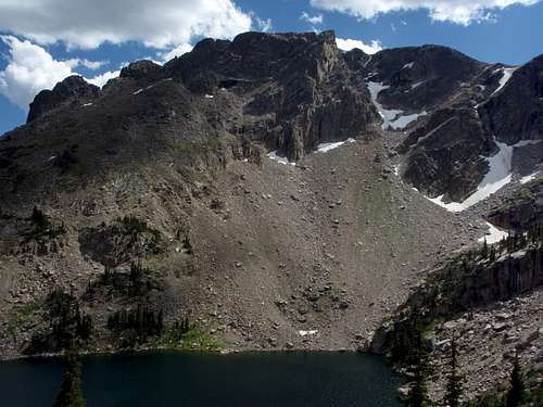 Ptarmigan Mountain from Lake Nokoni.
This is not the shortest route to the summit of Ptarmigan Mountain (approaching from the East Inlet Trailhead is shorter). However, this is probably the easiest approach as it avoids the bushwhacking required of the East Inlet Trailhead approach.
Getting There
Start at the North Inlet Trailhead.Route Description
Stats: Class 2, 19.7 miles (round trip), 4050 feet of elevation gain.From the trailhead, follow the North Inlet Trail for approximately 6.5 miles to the trail junction with the Lake Nanita Trail. You will pass Cascade Falls and Big Pool (a natural pool in North Inlet). Take the Lake Nanita Trail south for approximately 2 miles to Lake Nokoni. You will pass 'North Inlet Falls'. From Lake Nokoni ascend 440 vertical feet to the saddle between Point 11,322 and Point 11,733. Ascend the talus to the summit of Point 11,733. Descend Point 11,733 to the southwest then follow talus and tundra the remaining 0.7 miles to the summit. To shorten the summit day you may wish to camp in one of the many backcountry campsites found along the North Inlet and Lake Nanita Trails. A permit is required. |
Trail Profile and Map
The trail color represents the class of that portion of the trail.Green = Class 1
Blue = Class 2
Trail Profile The vertical unit is feet, and the horizontal unit is miles.  |
Map  Northwest Ridge from North Inlet TH. Northwest Ridge from North Inlet TH. |