
|
|
Route |
|---|---|
|
|
43.50212°S / 170.00647°E |
|
|
Hiking, Scrambling |
|
|
Spring, Summer, Fall, Winter |
|
|
One to two days |
|
|
Class 3 |
|
|
Overview
The Northwest ridge of Mt. Fox is a strenuous tramp, generally requiring 8 hours of travel round trip from Thirsty Creek. If you decide to travel further along the ridge above Mt. Fox towards Craig Peak, and overnight trip is advisable.Routefinding through the forest, especially on the descent, can be difficult as the trail is often patchy and poorly maintained. Fallen trees also add to the routefinding difficulties. Steep, muddy roots and rocks through the forest can make travel diffucult and dangerous. There is no trail on the ridge above Mt. Fox, so be sure to come properly equipped.
Getting There
The trailhead is located three kilometers south of the Fox Glacier township on Highway 6. There is a small pullout here for parking on the west side of the road, with a DOC trailhead signpost across the road.Route Description
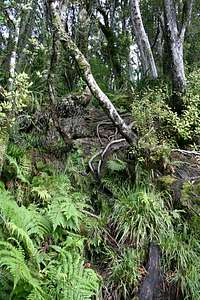 Typical trail conditions
After two to three hours of travel through the forest the trail emerges out into a scruffy bush, giving the first clear views out to the Tasman Sea. There is a small triangulation marker just after the trail exits the forest. From here, follow a series of white poles generally along the crest of the ridge, steadily gaining elevation through a mix of tussock and dense bush. The trail passes a number of small tarns, which supply the only water along the route after the spring snowmelt. This section of the track can be quite muddy. The summit of Mt. Fox is reached around an hour and a half past the point where the trail exits the forest. From here you can look out across the valley to the upper neve of the Fox Glacier, and up at the graceful Mt. Tasman and bulky mass of Mt. Cook. Descent is by the same route – take care to follow the correct path (look for the orange markers) through the forest, as several misleading paths branch off from the main route before gradually fading out.
Route Beyond Mt. Fox, to Craig Peak
 Craig Peak
Head southeast from the summit of Mt. Fox along the ridge, passing a few small tarns within the first kilometer. This is a good area for a campsite – be sure to wake up early for the sunrise before the fog moves in. From here, the route is pretty much your choice, as the broad ridge rises and falls as it continues towards the icy peaks.
 Terrain along ridge
After several hours travel reach a high point on the ridge (Point 1637), from which the remainder of the route up Craig Peak is visible. This was my turn around point – any further route information is appreciated!
Descend to the south to avoid sharp cliffs along the ridge crest, and follow the ridge until you reach the shingle slopes immediately below the peak. An ice axe and crampons may be necessary, as ice often lingers into summer on the upper slopes of this ridge. Take care on the descent, especially through the steep sections of tussock before rejoining the poled trail at Mt. Fox.
Essential Gear
In addition to standard hiking gear:Waterproof gear (wet high tussock makes waterproof pants a good idea, even in fine weather)
Gaiters (muddy!)
Insect repellant
Extra water - no water is available until tarns near the summit
For travel above Mt. Fox:
Trekking poles (good for searching for trenches in the tussock)
Map, compass
GPS is advisable for routefinding
Ice axe and crampons are generally required for ice on Craig Peak