-
 8430 Hits
-
 76.65% Score
-
 7 Votes
|
|
Route |
|---|---|
|
|
47.81300°N / 112.799°W |
|
|
Scrambling |
|
|
Summer |
|
|
Half a day |
|
|
Class 3 |
|
|
Overview
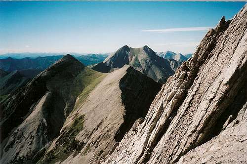
My eyes and my topo map (use the USGS Our Lake quad) tell me there are at least three decent routes up this peak-- the northwest ridge, the east ridge, and the west flank. The route I describe goes up the northwest ridge. Those uncomfortable with scrambling or exposure could go up and back down via the east ridge, but people who like climbs will prefer the scrambling on the northwest ridge to the steep scree climbed while attaining the east ridge. The west flank is a good alternate and can be reached either from this route or from lower points on the west side of Headquarters Creek Pass, though the latter will require a steep scree ascent and maybe some bushwhacking.When you view the primary image on the main page, the northwest ridge is the steep one going straight up from your viewing position to the summit. This perspective makes it look difficult or even unclimbable, but it is much easier than it appears to be. In fact, those others of you who enjoy Class 4 and Class 5 climbing, even tough Class 3, may feel a little disappointed at the lack of any significant climbing challenges on this ridge. The route I describe commits you to about 7 miles round-trip and 3600' of elevation gain. It took me about 3.5 hours in all (with a descent of the east ridge), but most people will take 5-7 hours.
Getting There

About 5 miles north of Choteau on U.S. 89, a paved road indicating skiing and fishing access heads left. Take it. About 17 miles later, take a left turn that shortly crosses the South Fork Teton River and becomes a gravel road. This is the South Fork Teton Road, and you follow it through increasingly pretty scenery for about ten miles to a parking area at its end. Along the way, you will have occasional views of Rocky Mountain to the southwest, and it is also visible through the trees at the parking area. These glimpses will give you some chances to assess conditions on and near the northwest ridge and decide if it suits your tastes. The parking area is about 1 mile past the turnoff for the Mill Falls campground and recreation area. Mill Falls takes only a few minutes to see and is pretty but not heart-stopping. On the right side of the road at the parking area, you will find the trailhead for Headquarters Creek Pass and Our Lake. You will want to head for the pass. These roads are passable for passenger cars.
Route Description
Hike to Headquarters Creek Pass, about 2.8 miles away and 1949' of elevation gain. The first half of the hike is mostly gentle and winds through an unexciting forest that yields few views, but look for wildlife for both your enjoyment and your safety. About halfway along, the trail follows high along the canyon's edge, and you can enjoy the suddenly open and enticing views of the canyon, two beautiful waterfalls, and the mountains. Soon you will make your second of three stream crossings on this trail (easy crossings in July, but some, especially the first, might be troublesome April-June), this one being a little bit below the base of one of the waterfalls.Now the trail reveals its trick-- you pick up most of the elevation gain along the second half, making this trail harder on your legs than dividing the elevation gain by the miles might suggest. As you climb the several switchbacks waiting for you here, start being alert for mountain goats; you are now entering their country, and they seem to have a knack for knocking rocks down in the direction of hikers and climbers. Shortly after the third stream crossing, you enter a lovely subalpine basin full of rock and snow and dominated by the northern face of Rocky Mountain. This is a nice place to catch your breath, snap some photos, and sip some water before the final push to the pass. There are two more sets of switchbacks before you reach the pass. The last little stretch to the pass is gentle and easy.
At the pass, enjoy the views (fire in 1988 burned much of the area west of the pass, exposing more rock and allowing you to witness the regeneration taking place) and study the northwest ridge taking off directly to your left. The key is to stay as close as possible to the west (right) side of the ridge. My pictures and your own eyes will suggest that you could find some challenging climbing on the east side of the ridge, but the rock looks pretty questionable. You could stick to the ridge proper for added fun and challenge, but it will only slow you down without giving much of a different perspective of the mountain. By all means, play around if time and energy permit, but don't waste time and energy for little real payoff.
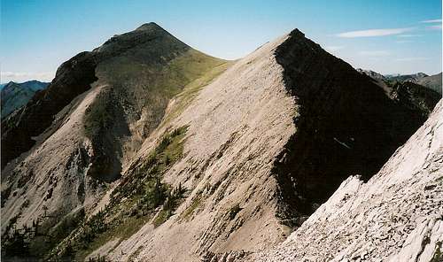
You can't get lost. Most of the route is Class 2 hiking across and up steep scree slopes. You will occasionally face some Class 3 pitches and will have to work over or under some deep "gashes" on the mountainside, but any experienced scrambler should have little difficulty finding a way. The final obstacle is a large rock wall (see photo) that presents all kinds of options ranging from Class 3 to probably low Class 5. Have fun here, seriously. After that rock wall, the summit is a couple minutes away and requires simple Class 2 ridge walking.
If the scrambling is not to your taste, traverse the ridge across steep and loose but easier terrain to reach the obvious saddle on Rocky Mountain's west flank. The west flank will provide a longer but gentler route to the summit.
But back to the summit-- enjoy that view. The summit itself is not the highlight. It's a broad mound of rubble, not some small, precipitous perch. You are only on the edge of the Bob Marshall Wilderness, not deep in its feral heart, but you are atop the wilderness and are already in wilder country than you will find almost anywhere else in this country outside Montana and Wyoming. You are in the realm of the wolf and the Great Bear, and although you probably will see neither one on this excursion, their presence and potential change everything.
Thumbs of Route, in Sequence


Essential Gear
Plenty of water-- it gets hot out here.Sturdy shoes
Trekking poles (helpful but not necessary)
Bug repellent for mosquitoes and a fast pace or body armor for the flies
Pepper spray and knowledge of how to use it-- stay away from here and all of the northern Rockies if you don't know how to act and react in grizzly country properly. If you don't know exactly what I mean, then you need to stay away instead of putting yourself and, consequently, the bears, at risk.
Climbing and Summit Views