
|
|
Route |
|---|---|
|
|
34.26140°N / 117.5972°W |
|
|
Hike |
|
|
Most of a day |
|
|
12.8 mile hike round trip |
|
|
Approach
In Southern California take I-15 or I-5 to I-10. From I-15 take I-10 west toward Los Angeles. From I-5 take I-10 east for 34 miles. Take either the Euclid Exit or the Mountain Ave Exit(Euclid runs into Mountain Ave). Follow either road until they intersect with Mt Baldy Road, make a right and follow this road through Baldy Village. At a leftward bend in the road a sign will point left toward Baldy Ski Area. Follow this road for 3 miles to the Baldy Ski Area. There will be a gate on the left-hand side that leads to a fire road. Park here and follow the road on the left-hand side.
Route Description
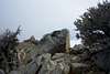
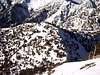
After parking at the fire road gate just before the ski area, start up the fire road. It very slowly winds its way up the hillside. After .9 miles the fire road intersects the trail for the Baldy Bowl(Hut Trail). Continue on the right hand fork, heading east. The road winds through the Baldy Ski Area, past lifts, up to the Baldy Notch(gaining 1700ft over 3.6 miles). From the Baldy Notch take the southbound trail that follows the ridgeline to Thunder Peak, where one of the Baldy Ski Area lifts terminates. From Thunder Peak you pick up the 3Ts trail that descends down 500ft, then quickly rises up 900ft of switchbacks to the ridge just past Telegraph Peak. At the top of the ridge take a hard left and head up the short ridgeline to the peak. The last set of switchbacks can be icy and hard to follow during early and late winter. Retrace your steps to return to your car. During winter months one can hitch a ride down the ski lifts to cut the trip short. Also from the Baldy Notch one can take a cross-country route strait through the ski area, cutting down the distance and making for a more interesting trip. There is approximately 3300ft of elevation gain over the course of this hike. This route is still easier than the Icehouse Canyon route.
 |  |  |
Essential Gear
May through October a sturdy pair of boots are all that is needed. In winter months crampons may be needed on the final hillside, and trekking polls are often needed to ascend the snowy hillside.
Miscellaneous Info
If you have information about this route that doesn't pertain to any of the other sections, please add it here.