
|
|
Route |
|---|---|
|
|
45.31940°N / 116.5319°W |
|
|
Hike/Scramble |
|
|
Most of a day |
|
|
Class 2/3 |
|
|
Approach
Take Highway 95 to Riggins, which is 153 miles north of Boise or 118 miles south of Lewiston, Idaho. Just outside the south edge of Riggins, look for a large brown recreational sign for the Seven Devils and Heavens Gate. This will be Forest Service road 517. Turn west on this road and follow it about 17 miles, almost to Windy Saddle. About 0.5 mile before Windy Saddle take the rough road down to the left which continues about 0.3 mile to the rustic Seven Devils Guard Station. There is a trailhead here and a few places to park in front, but away from the building.
 |  |  |
Route Description
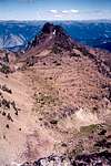
This route provides the easiest way to reach the summit of The Ogre.
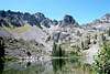
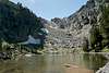
Hike south on Trail 101 for a long two miles to the Lower Cannon Lake Trail. Turn right here and continue for a little more than half a mile to the large stream crossing that is just before Lower Cannon Lake. There is a low, broad ridge separating this stream and the lake. Hike to the top of this ridge and follow it to the west toward the basin of Upper Cannon Lake. There will be some big rock between the two lakes, but pay attention to your path and hiking is generally all that’s required. Work your way towards the north base of the huge point that is north of The Goblin. There will be some good ledges to cross the base on. When they peter out you find yourself at an obvious worn path up through some boulders. The ground is formed of steep soil and the footing hard to maintain. Climb up on the side and take rights once on top for a short walk to Upper Cannon Lake. An option instead of the worn slide through the boulders is to continue straight west toward the tumbling stream and climb the boulders there and follow the creek to the lake.
Walk around the north side of the lake and continue up the inlet stream to the small pond at the north foot of The Ogre. Climb up the steep draw to the west to the basin above that will terminate in the high saddle between The Ogre and She Devil. From the trail near Lower Cannon Lake to this saddle is about two miles of cross country hiking and scrambling.
Just before the saddle is reached leave the upper basin and scramble up the talus slope that forms the northwest aspect of the summit formation. This is easy going, between the steep walls of the north and west ridges. The slope gets steep near the top, but soon opens up to the flat summit ridge. This is formed by a series of ledges and large blocky boulders that run east to the high point. The going is very easy, but there is a place one has to pull themselves up through a vertical opening in the blocks. Then its just an easy walk to the high point.
 |  |  |  |  |
Essential Gear
Good hiking boots are all that is required. An ice axe and crampons are recommended for a spring or early summer attempt when snow will be present.
Miscellaneous Info
If you have information about this route that doesn't pertain to any of the other sections, please add it here.