
-
 2711 Hits
-
 74.01% Score
-
 4 Votes
|
|
Route |
|---|---|
|
|
39.30490°N / 105.5366°W |
|
|
Hiking |
|
|
Spring, Summer, Fall |
|
|
Less than two hours |
|
|
Class 1+ bushwack finished by Class 2+ scramble |
|
|
Overview
 Looking northwest up Lost Park
This is a short, trail-less route through mostly well-spaced woods. Though short in mileage and modest in elevation gain, be forewarned that this route is best not attempted on “sense of direction” alone. Keep your compass / GPS bearing and proceed carefully. Neither ridge on the northwest slope is particularly well defined (to make for easy following) and criss-crossing old logging roads that are not marked on any map I have reviewed contour the slope. By paying close attention to your bearing on the return t rip, you should end up at or close to your vehicle and avoid a return slog along FS 801.
Roundtrip Mileage: Approximately 2 miles
Elevation Gain: 450 feet
Getting There
From US 285- Approximately 2 miles north of Jefferson or 4 miles south of Kenosha Pass, turn east on Lost Park Road (Park County #56).
- Continue east / southeast on Park County 56, which becomes FS 56, for approximately 6 miles to where FS 39 intersects FS 56.
- Continue with directions from the intersection of FS 56 and FS 38, below.
From Park County 77
- Turn north on Park County 39, which becomes FS 39, for 5.4 miles to T-intersection with FS 56.
- Turn right on FS 56.
- Continue with directions from the intersection of FS 56 and FS 38, below.
From the intersection of FS 56 and FS 38
- Travel for 10.3 miles to FS 134* (North Fork Road; see sign to North Fork Trailhead).
- Follow FS 1341.4 miles on FS 134 to a semi-open area with some parking.
- Park on wide part of shoulder/toe of arm up to UN 11060.
*Note on FS 134: In dry conditions, it’s suitable for 4x4, AWD & high-clearance vehicles. In wet conditions, 4x4 or AWD will be necessary. While not particularly rocky, the road is rutted and has a few rocks jutting out of the surface that will make 4x4 and high clearance a nice thing to have. Also, there are many unmarked logging road spurring off of FS 134 that do not appear on the Trails Illustrated map #105. Take care to stay on the main artery.
 Bring your map and compass
Route Description
- Depart your vehicle and head initially due south through the trees, gaining elevation moderately.
- After about ¼ mile, cross FS 801 (which appears to be a derelict logging road).
- Continue southbound as the route steepens, attempting to hug a barely discernable ridge, toward the first high point.
- Skirt the northernmost (first) highpoint to the northeast.
- (Normally, when bushwacking in this area I avoid northern slopes due to the denser timber. However, the wider-space topo lines / gentler terrain on the northeast edge of the series of summit ridge outcrops make this routing preferable to the steeper southwest slopes.)
- Continue past the northernmost outcrop, now trending south-southeast.
- Shortly after passing the middle outcrop, the summit will become apparent through the trees.
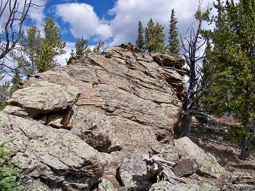
- Scramble (Class 2+) up the summit block (there is a weakness on the western side that eases passage) and enjoy the expansive views to the south.
- After enjoying a snack at the overlook south of the summit, carefully retrace your steps back to FS 134.
- Trail map (Trails Illustrated #105 Tarryall Mts, Kenosha Pass would meet most needs)
- Compass
- Trekking pole(s)
- Sturdy hiking boots with grippy soles and stiff ankle support
- Snowshoes after a heavy snowfall
- Water and snacks
- A camera to save memories of the high country views
- First aid kit
- Other standard backcountry essentials
 |
 |
 |
Left to right: Summit outcrop from the west (note weakness); Summit outcrop from the east; Rock outcrop just below summit.
Click on images to enlarge.
Click on images to enlarge.
Essential Gear
 Northwest Slope of UN 11,060