
-
 5987 Hits
-
 76.66% Score
-
 7 Votes
|
|
Route |
|---|---|
|
|
37.62740°N / 107.6399°W |
|
|
Hiking, Mountaineering, Scrambling |
|
|
Summer |
|
|
One to two days |
|
|
Overview
Turret Peak's Northwest Slopes Route is the easiest way to climb Turret Peak. Turret's first recorded ascent was done by Albert R. Ellingwood & Barton Hoag on August 17, 1920 (1). Their ascent route was the Northwest Slopes Route. The upper, north-facing section of the route holds snow until late June and is recommended to be climbed after snow melt.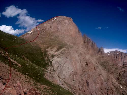 Turret Peak's Northwest Slopes Route
Getting There
Access to Turret Peak's Northwest Slopes is via Needleton, CO. Needleton is most commonly reached by the Durango Silverton Narrow Gauge Railroad. Roundtrip tickets cost $65 as of 2007. Avoiding the train requires an additional 1612 feet of elevation gain and 19 miles of hiking from the Purgatory Trailhead (2).Route Description
From Needleton, hike 260 yards north on the Animas River Trail, cross Pigeon Creek and hike an additional 0.2 miles to a meadow at 8,260 feet. Hike north looking for a fallen tree. Look for a trail heading east of the tree. This is the Ruby Creek Trail. Follow the Ruby Creek Trail to a small ridge at 9,800 feet. The Ruby Creek Trail continues north, but a thin, faint trail continues east. Take the faint trail until it fades. Continue bushwhacking up to a meadow at 11,740 feet in North Pigeon Creek. North Pigeon Creek is the creek between Pigeon Creek and Ruby Creek. This meadow makes a good campsite. From the meadow one can see Pigeon Peak, but not Turret Peak. Hike southeast 0.6 miles to the 12,780 foot saddle south of Pigeon Peak. There are two saddles visible from the meadow; the 12,780 foot saddle is the most northern. From the saddle Turret Peak is visible. Hike 0.3 east to the slopes just south of the Pigeon-Turret saddle. Gain Turret's northwest ridge. Follow the ridge to Turret Peak's upper north face and climb to the summit.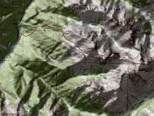 Turret Peak's Northwest Slopes Route Map. Click to enlarge.
Essential Gear
Ice axe and crampons if going prior to snow melt.References
1. Roof of the Rockies: A History of Colorado Mountaineering2. Colorado's Thirteeners: 13,800 to 13,999 Feet, From Hikes to Climbs