
|
|
Route |
|---|---|
|
|
46.31280°N / 9.72430°E |
|
|
Mountaineering |
|
|
Half a day |
|
|
AD / Glacier / Steep Snow |
|
|
Overview
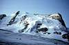
First climbed by A. von Rydzewsky with Chr. Klucker and Emile Rey on Jun 8, 1893.A classic glacier climb that is not often done. The crevasses and bergschrund can be nasty. This climb is recommended for the early season.
There are 2 other options:
to the left (east) of northern spur, the Bonacossa-Amstutz route (more direct) and to the right (west) of northern spur, the Kienzle-Rinderer route (dangerous) Same difficulty as the original one to the left (east) of northern spur, the Bonacossa-Amstutz route (more direct) and to the right (west) of northern spur, the Kienzle-Rinderer route (dangerous) Same difficulty as the original one
 |
Approach
From the Forno Hut , reach the foot of the glacier bay. whose foot rises into the NW face.Route Description
Climb directly up the face from the left between two rock outcrops. Go straight through steep (45 to 50 deg) snow/ice to a crevasse zone. Work through this, keeping to the left. Continue up easier snow to the bergschrund, which can at times be very difficult. Climb left onto the steep snow arete dividing the NNW and NW faces to reach the west ridge. Follow the ridge to the summit.There are two other options (thanks Gabriele!):
Go to the left (east) of northern spur, to the Bonacossa-Amstutz route (more direct).
OR
Stay to the right (west) of northern spur, on the Kienzle-Rinderer route (dangerous)
Same difficulty as the original route.