
|
|
Mountain/Rock |
|---|---|
|
|
36.90800°N / 118.853°W |
|
|
Fresno |
|
|
Hiking, Trad Climbing |
|
|
Spring, Summer, Fall |
|
|
9700 ft / 2957 m |
|
|
Overview
 |
 |
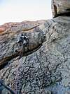 |
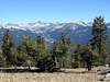
The Obelisk is a magnificent granite monolith in California’s western Sierra Nevada, & one of but a handful of Sierra peaks whose summit is only accessible to technical climbers. It is somewhat of a backcountry climber’s dream formation, being steep on all sides, aesthetic, & perched as it is high above magnificent Kings Canyon, less than 4 miles away & almost 7000’ below. The rock is typically high quality, and many aspects of the formation are immersed in chickenheads of remarkable density. The wonderful views from its summit include Tehipite Dome (the largest dome in the Sierra Nevada), the steep slopes leading down to the middle fork of Kings Canyon (the river itself is not visible), & distant High Sierra peaks, rising high above timberline. The most viable descent includes an exhilarating free rappel (2 50-m ropes req’d).
The first ascent of the formation was by prolific climber Allen Steck & Jim Wilson in 1947 via the south face. Other noted climbers to have visited the Obelisk include John Salathé & Fred Beckey (no surprise there). Current routes on the dome range from 5.5 (easiest way up) to 5.11s such as Far Out (.11c; see Supertopo thread describing the climb here) & the Obelisk Pillar (reportedly .11c R/X).
While not as dramatic as the impressive eastern Sierra, the region surrounding the Obelisk is special in its own way. Great granite domes erupt from the tranquil forests below, the giants of the High Sierra undulating dream-like on the eastern horizon. There is also a good possibility that you won't see anyone on the trail at all- seclusion unlike most parts of the Sierra! The Obelisk caps Tombstone Ridge, rising from Little Tehipite Valley, & forms the westernmost boundary point of Kings Canyon National Park.
Getting There
The Drive:Take highway 168 (most logically from Madera or Fresno) to the hamlet of Shaver Lake. Take a right (going E) on Dinkey Creek Rd. Take this for 11.6 mi. Take a R onto McKinley Grove Rd. Take this past some campgrounds & the sequoia grove for which it is named until you get to the resort establishment of Wishon Village. If you need any last minute supplies, stop at the store here. Continue up the road- at the “T” at 27.6 mi (from the Shaver Lake turnoff), go straight (not R). Driving over the dam, you will pass Wishon Reservoir on your L (the spillway will be to your right). Finally take a R at the road fork indicating Crown Valley trailhead sign (31.5 mi). Follow this road for another 1.1 mi to the trailhead (on your L)- parking is on the R-hand side of the road. This shows the starting point on topozone.com
The Hike:
 |
 |
 |
 |
 |
* Be aware that much of the approach to the Obelisk is over obscure, poorly-marked, & sometimes non-existent trails. Make sure to have a good topographic map & compass with you, & know how to use them!*
The hike to lower Geraldine Lake, where most climbers set up their basecamp, is approximately 8 mi. Elevation gain is a few thousand feet. With camping & climbing gear, expect this to take between half & most of a day.This being said, it is also a fairly mellow approach, there are ample opportunities for water, & the colors in the fall (there are multiple aspen groves) are beautiful!
• Crossing the street from the parking lot below, start at the Crown Valley TH (~6,720’).
• Cross a stream after following the trail for a few minutes, then take a R when the trail forks (.75 mi), following the arrow indicating “Statum Meadow.”
• Cross the stream, traversing up hillside, the stream now to L below.
• Reach the John Muir Wilderness boundary, cross stream again.
• Continue on, going up hillside & eventually reaching Statham Meadow.
• Continue past subsidiary trail that branches off to L, apparently closed (covered w/ trees, branches).
• When reach main part of meadow (fenced off- private property), take trail fork to the L indicating Crown Valley.
• Zig-zag up hillside until at top. Statham Meadow (with buildings) are now visible down below to R.
• Follow the faint trail through forest, going R at the fork indicating Spanish Lake.
• Start downhill, eventually reaching Spanish Meadow.
• Go L (towards Spanish Lake, not Little Spanish Lake), temporarily hugging the edge of the meadow.
• Go L at split in the trail, towards Crown Valley (branch to R goes to Spanish Lake)
• Continue past Spanish Lake, which will be above to the R.
• Upon reaching the next intersection, take the R branch towards Geraldine Lakes.
• Follow the trail, skirting the base of granite slabs to your R. Follow the trail R & head up the gully, granite slabs to your R, finally reaching ‘Spanish Pass.’
• Drop down to Geraldine Lakes below; take a faint trail from the pass to a prominent pine down & to the R; follow trail, which cuts back to the L at the pine, working around/through rocks & vegetation until you hit the lake below.
• Camp here- multiple plush campsites available near the southern shore.
• Climbing day: From here, follow trail around the lake to prominent a pine with a sign on it.
• Go R here, following faint trail uphill to the obvious gap above. Go L, following faint trail (or not) through forest, grass, brush, & across various talus piles towards the Obelisk.
• Head for the L side of the hill to the L (NE) of Obelisk. Go up the mellow hillside to ridge.
• Go R, following the ridge to top of the hill.
• Go to base of Obelisk, dropping off stuff at the base of the prominent subformation, to retrieve upon completion (the standard rap’ line will deposit you back here). A pine here indicates the National Park boundary.
The Descent
The standard descent from the Obelisk requires 2 50-m ropes & goes like this:• Scramble down to the obvious first rappel station NE from the summit- slings wrapped around a huge boulder, & reinforced with a bolt.
• A relatively short rappel from here brings one to a substantial ledge. Slings are tied around some monstrous chickenheads here & also reinforced with a bolt.
• Here comes the fun part! This rappel is approximately 160 ft long. The first 50 – 60 ft are steep but standard operating procedure. At a certain point, you will get to an obvious roof, & see the remainder of your rope swaying in the breeze, not touching anything until it reaches the notch between the subpeak & the Obelisk, approximately 100’ below. This free rappel is mad fun, especially in the dark when you can’t see the ground below!
• Downclimb exposed 3rd class to terra firma, or 1 more rappel takes you down in questionable conditions.
Ropes have gotten stuck & become entangled in the chickenheads between rappel stations at various times over the years. Be careful while pulling yours so they don’t meet a similar fate (esp. while pulling them during the first rappel when you still have another one to go!). A suggestion (once the notch has been attained) is to scramble up towards the summit of the subpeak a ways before pulling, thus pulling the rope(s) outward, & not just straight down, into the waiting jaws of the chickenheads.
Mountain Conditions, When to Climb
The best times to climb the Obelisk are in the spring and fall. The summer would likely be too hot for comfort.• NOAA weather forecast
Red Tape, Other Considerations
 Permit restrictions
While bear cans were not required as of this writing, they are recommended. While not “red tape” per se, be aware that the area is popular with deer hunters in the early fall- stay visible & don’t become venison!
Camping

Additional Resources
• The High Sierra: Peaks, Passes, & Trails, by RJ Secor (ISBN 0-89886-625-1)• Southern Sierra Rock Climbing- Sequoia Kings Canyon, by Sally Moser, Greg Vernon, & David Hickey (ISBN 0-934641-51-X), out of print
• USGS quads: Rough Spur (approach), Tehipite Dome (Obelisk itself)
SIERRA NATIONAL FOREST- Pine Ridge Ranger Station
P.O. Box 559
Prather, CA 93651
559- 855-5360
559-487-5155