
|
|
Route |
|---|---|
|
|
48.87194°N / 113.7854°W |
|
|
Mountaineering |
|
|
Summer |
|
|
A few days |
|
|
II |
|
|
Overview
Located deep in the Belly River, the Old Sun Glacier Route on Mount Merritt offers a rewarding and challenging route to the top of the lowest of Glacier National Park's six ten thousand foot peaks.
Getting There
The trail leaves either from Chief Mountain Customs or from Many Glacier.We originally planned to leave from Many Glacier, but after bear closures forced us to change plans, decided to leave from Chief Mountain Customs.
This route shaved a half a mile in distance and over 2600' in elevation gain one way!!
The Chief Mountain route is obviously recomended.
This trailhead can be reached in a reasonable ammount of time (3 to 5 hours) either from Kalispell or Great Falls (both have international airports) The trail which starts at Chief Mountain Customs on the Canadian/U.S. Border will lead you approx. 6 miles to the Gable Creek Crossing.
 Gable Creek Ranger Station
 Dawn Mist Falls
Route Description
The route starts by leaving the trail at the stream draining the Old Sun Glacier into the Belly River. You will first come across a spur camp used by trail crews maintaining trails in the Belly River Valley. After a hundred yards or so the human trails die out and a maze of elk trails will start to become apparent. Follow these for a quarter mile or so trending towards the east/northeast until a dry overflow streambed is found. Enlarge for more route detail.
 Old Sun dry streambed
Follow this to the base of the South Face of Mount Merritt, crossing a few streams en route. From there an apparent right slanting diagonal weakness will be found through the lower red cliffs to a broad scree ledge that traverses almost the entire south face. This is easy to find from a small meltwater pond almost directly below the highest point of the south face. From the meltwater pond more or less head straight north up the slope and you will be funneled into the gully. Head up this gully which leads north/northeast to the large scree ledge that goes across the entire south face of the mountain.
 Base of the diagonal scree gully
 Traverse across Mount Merritt's South Face
 Obvious Old Sun Glacier Waterfall
Traverse this ledge until below the ridge that splits the south face from the large north bowl that contains a prominent waterfall that drains Old Sun Glacier.
Work up to the right of the waterfall on class 3 cliffs until almost to the rim level of the waterfall.
 lip of the waterfall
 traverse to the Old Sun Glacier
 Gearing up below the Old Sun Glacier
Now it is time for some actual glacier climbing in Glacier National Park!
We climbed the route in late August/early September and found the Glacier in almost perfect condition. Ther 2008 season had left the glaciers in the park in pretty good shape. Almost no ice was encountered and could completely be bypassed with a little effort. Also, interestingly enough, we were suprised to find fresh grizzly bear tracks on the glacer as well. I guess it helps to have built in crampons!
The first part of the glacier is one of the stepest parts of the glacier climbing on the route, although it is only about 40 degrees, it still requires correct use of ice axes and crampons. Head up the glacier almost directly above where the waterfall that drains the glacier takes it's 700' plunge to the rocks below.
 first steep part of the glacier
Once to the top of this section, which is actually only a few hundred feet below where the normal route reaches the large saddle between Mount Merritt and Natoas Peak, begin a rising traverse to the west aiming for the easiest path through the bergshrund below the false summit.
 Most of the route to the summit
 fifty degree section
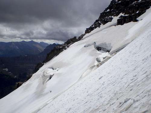 Climber's left
Follow this section directly up for 300-400 feet until you can traverse around a few small rock outcropings. From there the route to the summit will be obvious. Leave the snow a few hundred feet below the summit.
 Leaving the Old Sun Glacier
 Traverse the rocks in the middle of the picture to the left (southwest)
Then scramble the last few hundred feet to the top!
 200 feet to go!
Essential Gear
The route is really pretty simple in terms of technical skill needed to complete the route. A basic glacier travel kit (rope, prussiks, and a few screws or pickets)should be fine. We never felt like we needed to protect any rock sections, although people not familliar with Glacier's exposed traverses might want a belay through the traverse to the Glacier. yes, ma'am it gets MORE exposed after this!