
|
|
Mountain/Rock |
|---|---|
|
|
32.89825°N / 105.87301°W |
|
|
Otero |
|
|
Hiking |
|
|
Spring |
|
|
7659 ft / 2334 m |
|
|
Overview
Ortega Peak is one of the few true peaks in the Sacramento Mountains, as most are really just rounded knolls and high points on ridges which are covered by trees. Nearby Hershberger Peak is similar, but less accessible and has trees on the summit to obscure views. Ortega Peak is 7659', and offers some great views of the distant Sierra Blanca, White Sands, the Organ and San Andreas Mountains, and the Tularosa Basin. I can not imagine many folks making a long drive to hike this, so it is probably a locals only hike, or something to do while visiting White Sands. Thats said, the peak is actually a worthy hike and an interesting study in local geology and geography, and there are some neat pit stops to make while out hiking it.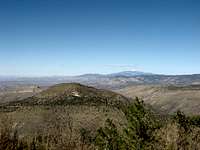 Ortega from Hershberger, and that is Blanca behind it.
Ortega in Relation to the Sacramento Mountains, Geolgy and Features
First, I need to point out that the area in which Ortega Peak sits, is part of the greater Sacramento Mountain uplift, which is in turn part of the Rio Grande Rift Valley. It is important to separate the Sacramento Mountains from the Sierra Blanca Mountains to the north. The Sierra Blanca Range is volcanic in origin, and this extrusive igneous material sits over top of the sedimentary rock of the area. A relatively low region lays between the higher parts of the Sacramento Mountain uplift, and Sierra Blanca Mountains. Interestingly, this area is slightly drier than the surrounding higher terrain, and it is where the better part of the Mescalero Apache Reservation exists. However, the Apache also have control over significant parts of the well watered highlands. If you could remove the Sierra Blanca Range, the Sacramento Uplift would be a large piece of mainly limestone rising above the Tularosa Basin, with the highest parts being just east of the Sunspot area. The terrain would dip slightly to the east, where most of the regions drainages and therefore water go, as well as the north and south. The western edge, would be marked by a pronounced escarpment, with some dramatic cliffs rising above the basin between the area just south of Alamogordo and the escarpment section just west of the village of Timberon, NM. South of the Timberon area, the escarpment disappears and low rolling terrain exists as it blends with the Guadalupe Mountains. North of Alamogordo, the western edge is composed of rolling drainages that feed small creeks to the west. This allows for some agriculture in the basin, but it does not have the dramatic scenery found south of Alamogordo. This geographic scenery can be observed from the Organ Mountains, and also the US 70 area west of Hollomon Air Force Base.While referred to as mountains, the Sacramento area is more of a high plateau, and it only superficially resembles a true mountain range. Geologically, the Sacramento Mountains are part of the Rio Grande Rift Valley Fault, and together with the San Andreas Range to the west, spread apart forming the Tularosa Basin. This is the same way the other ranges and basins formed in the Basin and Range Province which occupies a large part of the interior western USA. I write that the Sacramento is more of a high plateau, than a range, and only superficially resemble a mountain range, because once in their higher portions, you lose peaks, and find yourself in a rolling terrain of slightly higher ridges over top of lower drainage valleys, often with little more than a few hundred feet of elevation difference. Unlike the more dramatic ranges to the west; the Organ Mountains, the San Andreas Mountains, and those in Arizona, there are no impressive peaks, no sharp drop offs (aside from the western escarpment) and nothing that would suggest to the casual visitor that you were in a mountain range, aside from perhaps the dense forest vegetation in an otherwise very arid desert region. In my opinion, the Sacramento Range is very reminiscent of the Colorado plateau. Aside from the other small ranges, volcanoes, and high plateaus that characterize that region, there are a few similarities with the Sacramento. Coming from Arizona and being familiar with the Mogollon Rim area of that state, the Sacramento Mountains have a strong feeling of familiarity to them.
The Sacramento Mountains and Colorado Plateau both have a sudden drop off on one side and dip away from that to the other direction. In the Case of the Colorado Plateau, the Mogollon Rim is the steep drop, and the dip is to the north and Little Colorado River. In the case of the Sacramento Mountains, the sudden drop off is on the west, and the gentle dip is to the east and the Pecos River. Superficial similarities aside, there are far more differences than similarities, and if a visitor considers the relative size of the Sacramento Mountains when compared to the Colorado Plateau, we can see that the area is more of a mountain than a true plateau, though lines do blur. However, it is part of the fault block, Horst and Graben formation stemming from the Rio Grande Rift, the uplift is not as large as a true plateau, and when one looks at the other mountain to the north in the area, we see that the Sacramentos are really a compliment to the them. The Sandias and Manzanos, as well as the section of the Sangre De Cristos north of the Blanca Massif, all have east dipping slopes with steep western sides.
 Beeman Ridge, above some of the development that has spread on to the lower slopes of Ortega Peak. Notice the exposed strata below the ridge, contrasted with the west tilting strata found on the west side of Ortega's slopes.
Ortega Peak sits on the eastern edge of Alamogordo, NM, and the western edge of the Sacramento Mountain uplift. As written earlier, most of the western edge is either steep limestone cliffs, as it is to the south of Alamogordo, or gently rolling hills, as it is to the north of Alamogordo on up to it's merge with the Sierra Blanca Range. This section of the escarpment, or western edge near Alamogordo, has one of the few areas of peaks, with a canyon separating these foothills from the main body of the Sacramento uplift to the east. This canyon likely formed as a fault opened up as the valley below continued to spread apart. The northern and lowest point in this canyon is near Highway 82, and is separated from Alamogordo proper, by a high ridge, sometimes called Beeman Ridge as well as Horse Ridge. This ridge has a steep south west face, and sits over the New Mexico Museum of Space History. Beeman/ Horse Ridge contrasts sharply with the Ortega and Hershberger peaks, as while they appear to be a continuous feature, they really are not geologically. A divide exists between the high point of Beeman Ridge and Ortega Peak, with a canyon drain running due west of that, and there probably is a fault separating the two directions of strata orientation. Much like the west dipping San Andrea Range on the west side of the Tularosa Basin, Ortega and Hershberger peak sit atop a small west dipping area of rock. All of the sedimentary rock strata are parallel and tilt toward the city of Alamogordo and basin below. This contrasts most other areas of the Sacramento Mountains, which tilt east.
 Notice the west dipping sedimentary rock strata against the general profile of Ortega Peak.
Overall, the geology of Ortega is somewhat unique. The majority of the Sacramento Mountains are limestone and in some areas, marble. A few locations, such as Ortega and nearby Hershberger Peak appear to be extrusive igneous volcanic material; possibly Rhyolite or Dacite. Lower down, some of the rock looks to be of the same material found in the Organ Mountains near Las Cruces; Quartz Monzonite. Either way, Ortega Peak is not limestone, and there are areas which are also not limestone or calcareous rock. Again, something largely unique to the main body of the Sacramento Mountains.
 What is believed to be a Gold Mine. It is definitely a mining test pit, and it would not exist in pure limestone rock.
This somewhat unique geology has done more than create a peak with some rare rock for the location, it has also create some features not expected in an area of mostly sedimentary rock. A mine, possibly for gold, exists just off of the "A" trail, at about 1000 feet up. Literally just off the trail a large crack or fissure exists. Up to perhaps 50 feet deep, the fissure is perpendicular to the trail and the sedimentary rock layers. It almost shows how the canyon to the east opened up eons ago. As the fissure would provide an excellent channel for water to run into and begin the erosive process. You can see the fissure in satellite images, and I even wonder if it is partly the result of former igneous intrusions into the strata. The large canyon and probable fault on the east may have allowed for igneous rock to reach towards the surface. However, more interesting is the intrusive igneous material lower down, and the similar appearance to rock found in the Organ Mountains to the southwest.
This may sound a little far fetched, but just north of the Sierra Blanca are the Carrizo and Capitan Mountains, which are noted for their formations of Rhyolite and Quartz Monzonite. The most dramatic parts of the Organ Mountains are the Quartz Monzonite organ features, and the adjacent rounded Rhyolite peaks just south of the dramatic organ peaks. South of the Rhyolite peaks, the Organ Mountain Range is Limestone, as are both the Franklin Mountains in Texas, and the San Andreas Mountains north of the Organ Mountains.
 Some exposed volcanic rock at the summit of Ortega Peak.
Getting There
In Alamogordo, NM, take 10th St to it's eastern end in a neighborhood east of Scenic Drive. At the fire station, drive north and look for the wash that crosses under the road. There is currently a small plastic sign placed by the Forest Service for trail #119. Park here.Primary access from Alamogordo uses the A trail, # 119. You will know you are on the correct trail because you will hike past the large "A" painted on the rock on the eastern side of the town. The hike gains about 3100' over 4 miles, 8 miles round trip. Take trail 119, which also is used by ATVs and bikes, to near the summit. About 1,000' after a large water tank close to the summit, look for a small social trail taking off to the east, and on the south slope of the peak. If you can't find it, just gain a low saddle on the south side of the peak and obtain the summit from there. You may find the trail on the way down, but you can also just hike through the forest, as it is pretty open. Watch for cactus and pointy vegetation.
Red Tape and Season
The Lincoln National Forest may close in spring due to fire danger. Contact them at: 575-682-2551, if it is dry and you are concerned with a forest closure. Otherwise, access is free and easy.See also:
Fire Danger Updates
Fire Danger is posted on the FS homepage, see the Sacramento District.
The best season is probably spring, but fall is a close second. Summer will be hot at the bottom with storm chances, and winter is cold. Not Montana or Michigan cold, but not balmy like Phoenix, AZ.
Camping
You could camp nearby in a Forest Service Campground near Cloudcroft, NM, or at White Sands (backcountry only), but most likely you will be coming from nearby and not need to camp. If you are coming from a great distance, consider the Forest Service number to inquire about camping up high, or just back country camp and forget about it, unless there is a closure for fire danger. Just be warned, the Sacramento Mountains are heavily used by weekend ATV users. There are a ton of cheap to expensive motel and hotel rooms in Alamogordo, NM.Knowing is Enjoying
Ortega is sort of a boring hike. The trail, it sucks. There is no way around it. The peak is quite low, and if you came to summit higher mountains or more interesting summits, you likely went to Sierra Blanca, or the Organ Mountains, or maybe Guadalupe Peak (especially if you're from Texas as we all know the western United States stops at the Texas/ New Mexico state line, and it's all California after that). Knowing a little about the geology of the area can make the hike interesting, as it is surprising to note just what exists here.A power hiker could do a car to car summit in 4 hours or less, but why do that if you are only here one time? The mine is an interesting stop, and the fissure is a geologic feature worthy of exploration in it's own right.
See Also
Additional Images:imike's images