
-
 718 Hits
-
 79.78% Score
-
 11 Votes
|
|
Route |
|---|---|
|
|
44.66156°N / 14.37029°E |
|
|
Download GPX » View Route on Map |
|
|
Hiking, Via Ferrata |
|
|
Spring, Fall |
|
|
Half a day |
|
|
Hiking: T3, Ferrata: B |
|
|
Overview
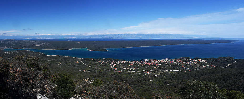
The most usual tour on Osorščica mountain is the traverse of its whole massif by the main ridge. But that one is quite popular, tourists are helped by a road and on the tour you miss a few quite nice places. Here is another proposal. You will traverse a big part of the SW face, visit two or three archaeologically important, nice caves, then climb on the main ridge by an easy ferrata and from the most beautiful promontory descend back.
Getting There
You start the tour above the tourist resort of Nerezine, Lošinj island. There on the main road two trails are starting (actually they are starting already down in the town). It doesn't matter on which of them you start the round tour, but enough parking places are only on the northern one, near the Pešćine hamlet (on the Google Map it says "Parking za na Televrin"): 44.66310448441349, 14.386426222975459
General Information
Overall difficulty
It's a medium demanding hike. The most challenging (T3 on the Swiss Hiking Scale) is the short, really easy ferrata (ferrata B grade). You may find some challenges also in following trail blazes on a wild, karstic terrain.
| See full screen |
GearGood sturdy shoes are needed and hiking poles are very recommended. For orientation have the online map on your phone, but be sure to have also an off-line version. The online version of my map is here: https://umap.openstreetmap.fr/en/map/kvarner_559091#13/44.6651/14.3825 Altitude gain / EffortAltogether you make only 11.6 km of distance, but on that rugged, demanding terrain that's not a relevant information. Also the altitude gain is not a big one. From 78 m above sea level you ascend on only 557 m. Still, the route goes up and down, so you will do 800 m of altitude difference at minimum. Altogether don't underestimate the time needed for a tour. 6 hours is safe, but hurrying you can do it also in 4 hours. And you will need quite some time for exploring caves and carefully orienting. TimesRoughly count on the following times:
For the whole round tour that's approximately 5 h 40 min. |
Best season and day time
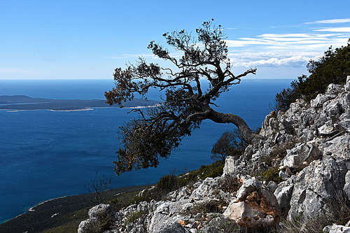
You can do the tour in any season, but winter on Kvarner islands can be cold and winds chilly. High summer is also not the best time, because those slopes of Osorščica can be very hot and there's absolutely no water. In any case choose a clear day, because majestic panoramas from the summit ridge are one of the tour highlights.
Even if due to hot sun on those slopes being early in a day is an advantage, you will have the best light to enjoy scenes only in the afternoon. Both caves are west oriented, so choosing the second half of a day is a good idea.
Route Description
From the parking place where the normal ascent route to Sv. Mikul church starts (you will return by it) you walk first down on the main road (D100) and by the road southwards some 1 km. Where a bridge overcomes a dry valley (after that the road turns towards the SE) - just before it (on the left are the last houses of Nerezine), you will notice a tiny path to the right (W), down in the valley. Soon there's also the first red mark of the trail, coming from Nerezine. So, you could perhaps also go to the houses and from there follow the marked path below the road.
Then the marks lead you by a good, broad path through a corridor of dry stone walls - towards the W and then SW. You gain altitude and cross a side mountain ridge. From the flat valley on the other side you regain the ascent, the path traverses rough gravel slopes. So you reach the main ridge of Osoršćica - the trails branching is called Počivalice, 234 m. There you turn to the right (towards Sv. Nikola).
The ascent goes further towards the W and soon we reach another trails branching, 271 m. To the right goes the path to Sv. Nikola, but we continue straight, following the marked path to the caves (inscription: "jame"). At first it's broad, newly marked, and it descends slightly. Till the broad, forested valley we lose some altitude (the lowest part is some 250 m), then the path starts ascending again. The section over gravel slopes is steep and we overcome it in short turns. Anyway the path is winding a lot, so carefully follow the marks! In those dense bushes you would get nowhere if losing it. The ascent is considerable and we reach the branching 385 m. To the right goes ferrata, continuing (towards the W and later NW) is the path towards the caves - descending again.
On this branching we must decide. If we shall return here and climb the main ridge by the ferrata, you can leave some equipment here. In 2 hours you'll be back. The other option is to carry everything with you and from the second cave (Vela jama) continue further northwards , gain the main ridge and the highest summit of Osoršćica (Televrina), and then start returning by the main ridge.


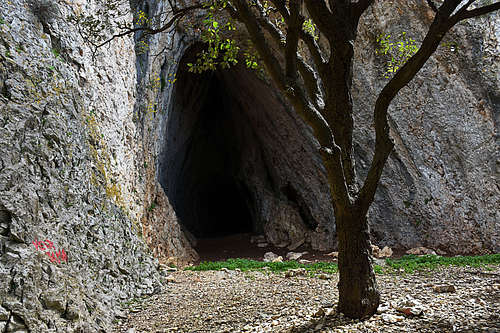
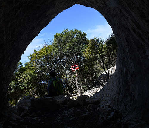
The trail continuing is still well marked, but the path gets weaker - on some places it almost disappers. We first descend below distinct crags, then continue traversing the slopes. When reaching high, compact crags again, you are already near the Organac cave. That one is fine, but not so famous as Vela jama. After exploring it, just continue. Vela jama cave is on even a lower altitude. In the distance you already see the crags where there's the arranged Osoršćica climbing area. You traverse more slopes, keeping low enough, cerefully following marks. In another 30 min you are at the beautiful Big Cave. You will not find any archaeological artefacts, because the 4 meters thick cultural layers in the cave are already well explored. The floor is covered with goat shit, instead.
|
|

If you decide to return by the approach path, you will need another 1 h to reach the branching 385 m. From there continue up (N-NE). In the beginning the slopes are steep, rocky, requiring some careful walking up or even very easy climbing (T3). When you gain some 30 m and get above the cliffs, you have above you only gravel slopes. The path goes up in turns, you all the time see the communication tower above. Reaching some 30 m below the main ridge, the path climby over steep cliffs and is secured by cables. The difficulty of this ferrata section would be around grade B. You exit just on the final parking place of Osoršćica.

From the tower (by its S and E side) it's worth going down to the third cave. As a natural feature it's far less attractive, but if you believe an ancient legend it has a big historical value. In that small cave in the beginning of the 11th century St. Gaudentius, the Bishop of Osor was living one year, before leaving the island for Italy. Not a comfortable dwelling, though! You descend to the cave in good 5 minutes from the tower, and soon you are back up on the main ridge again.
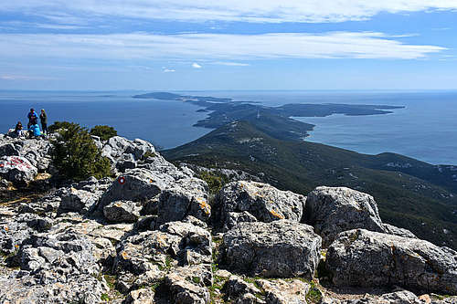
The next goal is the small church of Sv. Mikul (St. Nicholas), 557 m. It stands on the nearby ridge elevation, which offers one of the most beautiful panoramas on the Adriatic - on the SE part of Lošinj island.
|
From St. Mikul church you best go down to Nerezine by the normal route (not further down by the ridge towards the SE!). So you descend back a few minutes by the path you came to the church and only there deter to the right - towards the NE and later continue to the E). The good path is well beaten and marked and you will quickly descend to the parking place above Nezerine.