A "calanchivo" side (or bad side) which therefore contrasts with the opposite one, located immediately West of the Municipality of Saint Nicolas (more precisely nearby the Village of Fossaz Dessus; 1242 meters; small Church of San Domenico) and on the border with the Municipality of Avise (Village of Charbonnière; 1287 meters; Church of Saints Lorenzo and Barbara). And, again for greater precision, positioned (Calanques and pyramids) in the forest above the junction between the
Torrent of Méod and that of
Verrogne, called
Torrent de la Crete; then all on the Southwestern slopes of
Becca France (2312 meters, very famous for the landslide of 6 July 1564, exactly at hours six, with over 600 deaths in the ancient Village of
Thoraz or
Thora). A large balcony, which extends from East to West (towards Mont Blanc) above the four Municipalities of Sarre, Saint Pierre, Saint Nicolas and Avise overlooking the flow of the Dora Baltea. Above this, Up to 10,000 years ago the great Balteo Glacier flowed which, originating from the glaciers of the White Group, reached the gates of the nearby city of Ivrea, now in the Canavese area in the Piedmont region. As its left hydrographic and orographic lateral moraine (North), known as "La Serra", clearly demonstrates; while a residue teems with a series of small lakes (such as Lake Sirio) testifying to what remains after the melting of the ices. While from the lateral valleys and perpendicular to the Dora they sent other glacial flows which performed the function of tributaries; retreating the same, the land was modeled with large moraine-type terraces
(see the morainic hill nicknamed "Gargantua" near Gressan Municipality and below the terraces of the Conca di Pila). The work of river waters and snow and rainfall has further modified the appearance of the territory, especially in conjunction with the hardness of the rock. More resistant rocky banks have diverted the course of the streams, while the more frail earth-morainic deposit has been "worked" over time, also with the help of wind erosion.
LEGENDS or TRUTH ?
Moreover (incredibly) is also an ancient literature with stories, sayings and tales on the CALANCHI (bad lands) and, above all, on the PYRAMIDS of EROSION.
But we who are Scientists feel compelled to unmask these impostures on them (males) and on them (females). That they are not the work, legendary at times widespread, of Fate (Fairies), Magicians and also of the Devil and not even of artists intent on sculpting human or alien features, but of continuous erosion. Which, contrary to what may appear at first glance, is not that it raises the pyramids but lowers, digging, the underlying territory. That's why they seem to grow in height, while instead the ground at their feet is lowered. Unless it is really the work of a group of Devils stonemasons, such as to shape the "hat" of the same. To then have fun rushing it into the ravine, leaving them naked. The same pyramids, out of modesty and shame, often, even deciding to disappear ...
Map of the upper area above Saint Nicholas & Saint Pierre Municipalities, by maria grazia s 2006
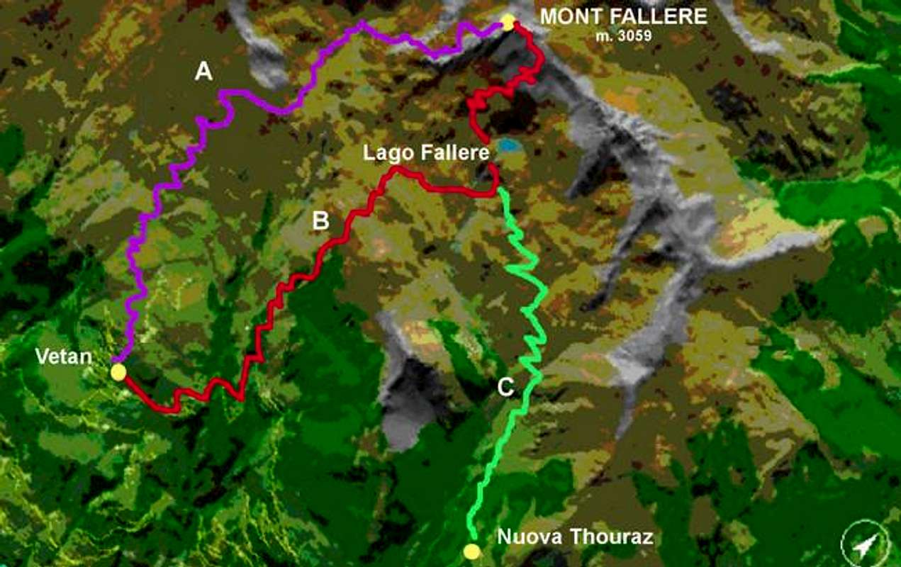
Anche la Valle d'Aosta possiede le sue piramidi di erosione glaciale, tra le quali voglio illustrarvi quelle concernenti tre specifihe località: 1)- Le piramidi di erosione nel vallone soprastante il Comune di Saint Pierre; 2)- Le piramidi nella parte più elevata della Gorgia del Dard, che l'Abate Joseph Maria Henry battezzò nel 1800 come il "Muro del Diavolo"; 3)- Le piramidi o meglio il ripido muraglione incombente sulla Strada Regionale nel tratto che unisce i Comuni di Nus (ad Nonum Praetoriae) e Quart (ad Quartum Praetoriae), entrambi subito alle porte orientali della Città di Aosta (l'antica Augusta Praetoria Salassorum del 25 avanti Cristo), tra le due località di La Planta (o Plantaz) (540 metri) ed il piccolo Villaggio con torre di Chétoz (621 metri); 4)- inoltre, ritornando alla zona soprastante il Comune di Saint Nicolas ed al confine con quello adiacente di Saint Pierre, sussistono altri calanchi con alla base una mezza dozzina di piccole piramidi di erosione. Queste ultime risultano collocate tra l'ampia Conca di Vetan (ad Ovest) ed il valloncello che dal Villaggio di Verrogne (1595 m; Chiesa di San Teodulo) risale verso Nord-nordovest fino ai piedi del Mont Fallère (3090 m); montagna, quest'ultima, che costituisce la cima maggiormente elevata di questo piccolo sottogruppo posto a cavallo tra la Valle Centrale della Dora Baltea (a Meridione) e la Valle del Gran San Bernardo (a Settentrione). 5)- Questa ultima zona può essere distinta in due parti differenziate che riguardano: a)- il settore di destra (guardando) ovvero Orientale che concerne il Torrent de la Crete e quindi compreso tra i Villaggi di Rossan (ad Ovest) ed orléans (+; 1142 metri) sull'opposto versante; b)- l'area sottostante le frazioni di Rossan, Rumiod de la Chapelle, Rumiod de Lé, Rumiod Dessous e Chantel (1203 m). Ed é proprio a quest'ultimo che si rivolge specificamente questo lavoro.
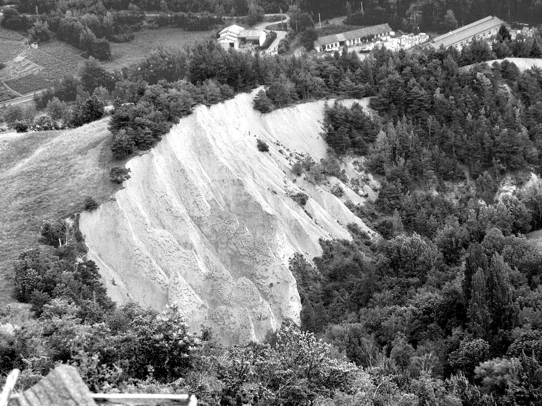
Un versante calanchivo che fa quindi da contraltare con quello opposto, situato subito ad Occidente del Comune di Saint Nicholas (Villaggio di Fossaz Dessus; 1242 m; piccola Chiesa di San Domenico) ed ai confini con il Comune di Avise (Villaggio di Charbonnière; 1287 m; Chiesetta dei Santi Lorenzo e Barbara). E, per maggiore precisione, posizionati (Calanques e piramidi) nella foresta al di sopra della congiunzione tra il Torrente di Méod e quello di Verrogne, detto Torrent de la Crete; quindi il tutto alle pendici Sudoccidentali della Becca France (2312 metri, famosa per la frana del 6 Luglio 1564, per l'esattezza alle ore sei in punta, con oltre 600 morti nell'antico Villaggio di Thoraz o Thora). Un ampia balconata, questa, distendentesi da Oriente ad Occidente (verso il Monte Bianco) al di sopra dei Comuni di Sarre, Saint Pierre, Saint Nicolas ed Avise affacciandosi sopra lo scorrer della Dora Baltea. Sulla quale fino a 10.000 anni orsono scorreva il grande Ghiacciaio Balteo che, originatosi dai ghiacciai del Gruppo del Bianco, raggiungeva le porte della vicina Città di Ivrea, ormai nell'area del Canavese in Regione Piemonte. Come palesemente dimostra la sua morena laterale idrografica ed orografica di sinistra (Nord), conosciuta come "la Serra"; mentre, a residuo, pullulano una serie di piccoli laghi (come il Lago Sirio) a testimonianza di ciò che rimane dopo lo scioglimento dei ghiacci. Mentre dalle vallate laterali e perpendicolarmente alla Dora sendevano altre colate glaciali che svolgevano la funzione di affluenti; ritiratosi i medesimi, il terreno veniva modellato con grandi terrazzamenti di tipo morenico (vedi la collina morenica soprannominata "di Gargantua" presso il Comune di Gressan e sottostante ai terrazzamenti della Conca di Pila). Il lavorio delle acque fluviali e delle precipitazioni nevose e pluviali hanno ulteriormente modificato l'aspetto del territorio, soprattutto in concomitanza della durezza della roccia. Banconate rocciose più resistenti hanno deviato il corso dei torrenti, mentre il più fragile deposito terroso-morenico é stato "lavorato" nel tempo, anche con l'aiuto dell'erosione eolica. La fragilità di alcune tipologie di terreno, insieme alla forza di gravità con relativa spinta e quindi scollamento e relativo scivolamento verso il fondo valle, hanno completato l'opera, portando lentamente alla luce calanchi e piramidi di erosione.
LEGGENDE oppure VERITA' ?
Inoltre (incredibilmente) esiste antica letteratura: storie, detti e racconti sui CALANCHI (in inglese "terre cattive") e, soprattutto, sulle PIRAMIDI di EROSIONE.
Ma noi che siam Scienziati ci sentiam in dover di smascherare ste imposture sui medesimi e sulle stesse. Non opera, leggendariamente a volte diffusa, di Fate, di Maghi ed anche del Diavolo e neppure d'artisti intenti a scolpire sembianze umane o aliene, bensì di continua erosione. La quale, contrariamente a quanto possa apparire a prima vista, non é che innalzi le piramidi ma abbassa, scavando, il territorio sottostante. Ecco perché par che le medesime crescan in altezza, mentre invece é il terren ai lor pié che s'abbassa. A men che non sia davvero opera d'una frotta di Diavoli scalpellini, tali da modellar anche il "cappello" delle medesime. Per poi divertirsi a precipitarlo nella burra, lasciando le stesse ignude. Le stesse, per pudicizia e vergogna, spesso, decidendo anche di scomparir ... Approach to Rumiod Dessous (Lower)
4) - There are also badlands (calanques) with the minuscule and underlying erosion pyramids, placed at the base of the same and above the confluence of the Torrent de Méod with the Torrent de la Crete,, in the narrow valley above the small Villages of Torretta
(1002m), Babelon, Bosses, Charrère
(812m), sited on Eastern side, and nearby Rossan
(1322m) and Rumiod
(1270m) Hamlets and Bressan very small Village
(1082m) in the opposite side or Southwestern.
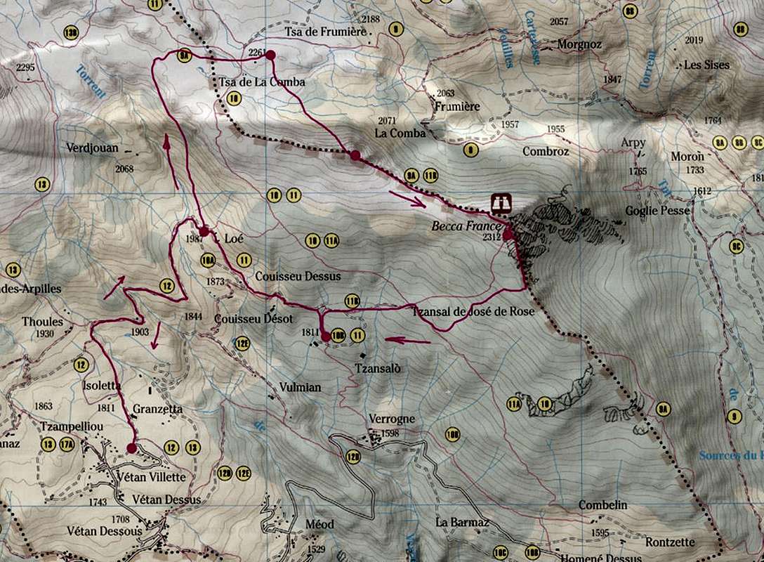
APPROACH:Through the Regional Road to continue with motorized vehicles from the City of Aosta to the Municipality of Saint-Nicolas: from the A1 motorway exit at Aosta Ovest Station (in the Municipality of Aymavilles) follow the signs for Courmayeur until reaching the Municipality of Saint-Pierre (680/760 meters on average). Then take the crossroads for Saint-Nicolas (in Chevrayron or better in those of Cognein and Pommier at the Cemetery) and go up a beautiful road which, passing the Hamlets of Vereytaz, Montovert, Evyan, Lyveroulaz, Gratillon and Ferrère in about 8 kilometers reach the Municipality of Saint Nicolas (ancient Church nearby the characteristic wooded rocky hill of
"Bois de la Tour" with PicNic Area and Monument to partisans; once in Saint-Nicolas continue for about 1 km following the signs, passing through the center of
Fossaz Dessus, leaving to the West the deviation towards Charbonnière 's Hamlet (1263/1287 meters with Parking) positioned just beyond the Torrent de Gaboé, as well as already in the underlying Municipality of Avise, with a great bridge on the Dora Baltea main River. From Fossaz (1200/42 meters; Parish Church at the "Bois de la Tour"); the asphalt road changes direction heading East-northeast, successively reaching the Villages of Chaillod
(1218 meters; Church of San Rocco), Ravoise
(1321m),
Persod (1351 meters; Church of Sant'Antonio); from this point, leaving the continuation for the Villages of Gerbore
(1633 meterrs; small Church of San Giacomo), Vetan Dessous and Dessus on the left (
1670/97, 1737//80 meters, in Northwest) as well as on the right (Northeast) the one for Petit Sarriod, Méod Dèsot and Damon
(1498 meters; Church of San Bernardo);, bypassing two Torrents de Méod and de la Crete arrives at the
Village of Verrogne (1595 meters; Church of San Teodulo), just positioned vertically above the badlands area.
BASIC ITINERARY
Even the route described here develops around the area of the badlands of the Hamlets of Rumiod and Rossan. An afternoon visit is suggested or, better, recommended, when the badlands are well lit frontally by the sun and, probably, without snow: while for the period a long term the two seasons of spring and autumn are indicated, when the vegetation is not too dense and such as to prevent adequate
"exploration" . In any case, this is the best route to be able to view the badlands and the small erosion pyramids, which extend over the rocky gorge between the upper altitude of
about 1333 meters and the lower one of
1002/948 meters around, the latter corresponding at the junction of the two streams mentioned above and coming respectively from the Vulmian Pasture
(1644m) and the Loé Alp
(1986m), passing through Verrogne. The upper point of this area, marked by considerable erosion, can be reached through a small municipal road which, starting from the East from Rossan 's Hamlet, heads Northeast and, as soon as it passes the Torrent de Méod, reaches the altitude of
1368 meters immediately at beyond the same little stream it and above the affected area. To summarize, to "use" this route, from the junction
908 meters, after the built-up area of Montovert
(802 meters; Church of Santa Margherita), you have to leave the Regional Road to Saint Nicolas instead heading towards the Northeast and reaching the
Village of Champretavy (946 meters; clear directions); from this last, through three long and wide hairpin bends, arrive in succession to the hamlets of Chantel Dessous
(about 1300 meters), and, leaving the deviation for Chantel de Lé, and Chantel de la Chapelle on the left. In a very short time you are in
Rumiod (San Bartolomeo Santa Barbara Churches) and just above into the
Rossan Village (1322m). In this final part of the route, before the Regional Road turns decidedly to the West towards Petit Grand Sarriod and Vetan 's Basin, the view on this geomorphology is clear, evident and appreciable. And also somewhat exploitable for photographic purposes, while the visit on foot with the path is not at all simple as the terrain is rather difficult. Instead, you can easily observe both the gullies and the attached earthy pyramids positioned just below the Village of Rumiod Dessous
(1203/26m) along the valley carved by the waters of the Torrent de Montovert that reaches the homonymous village
(802 meters; + Church of Santa Margherita) almost on the valley floor, as well as on the border with the Municipality of Villeneuve. A series of earthy flows separated from each other by very sharp ridges which, descending towards the South, slope steeply in this section where the valley sinuously widens. All this, as for the erosion pyramids near Fossaz / Saint Nicholas, which starts from verdant bumps of meadows immediately upstream and West of the very small village. Always in this case, also in this considerations, the same considerations apply, already externalized to Fossaz, on the danger of the territory to visit, also because there are no protections whatsoever. In fact, as can be clearly seen in the photographs, the meadows end abruptly on the precipice forming a long balcony between the row of trees that suddenly stops on the edge of the same. An interruption of the forest of
about fifty meters that reveals, from the point of greatest difference in height, all the existing exposure on these dizzying slopes that fall downstream for
over 60 meters, starting to "forge" the shapes of the first pyramids down below. Then, turning more to the southwest in the sector between Champretavy
(946/57m), to the East, and the small village of Evian
(988m) the slopes gradually decrease while the ground is increasingly "attacked" by vegetation and woods who begins to climb the badlands trying to recover the lost position. In the perennial struggle that the force of gravity has accentuated by making the immense ancient glacier "slide" downstream. Now reduced to dust ...
ALTERNATIVE ITINERARY:
Wanting instead to get closer to the entire area in question at regard of calanques and erosion pyramids, it is convenient, reached as in the previous or basic itinerary, the
Hamlet of Champretavy (946 meters):
a)- to continue on the same road and, after a long hairpin bend first towards West-Southwest and then Northeast , reach the crossroads
1068 meters; on the right of which a very small municipal road starts which, going North-northeast, reaches the little
Village of Bressan (1082/7 meters), positioned just above the
948 meters junction of the two streams of Méod and de la Crete as well as facing the badlands.
Or and also by the
VARIATION: b)- always starting from Champretavy but at altitude of
957 meters take path
n ° 12 C on the right (North) which in a short time joins with
n ° 12 A coming from the adjoining little
Village of Bachod Dessus (about 870 meters) to then both join with the path
n ° 12 B (from the deviation
1110 meters of the small municipal road again from Champretavy) and with this last numbering in Bressan neighboring a pool of water.
4)- Inoltre esistono dei calanchi con le sottostanti minuscole piramidi di erosione, poste alla base dei medesimi nonché soprastanti la confluenza del Torrent de Méod con il Torrent de la Crete, nello stretto vallone soprastante i Villaggetti di Torretta (1002 m), Babelon, Bosses, Charrère (812 m), situati sul lato Orientale, nonché nelle vicinanze di quelli delle Frazioni di Rossan, Rumiod e del piccolissimo Villaggio di Bressan (1082 m) sull'opposto versante o Sudoccidentale.
AVVICINAMENTO:
Utilizzando la Strada Regionale per il proseguimento con mezzi motorizzati dalla Città di Aosta al Comune Saint-Nicolas: dall’uscita dell’Autostrada A1 presso la Stazione di Aosta Ovest (in Comune di Aymavilles) seguire le indicazioni per Courmayeur sino a giungere al Comune Saint-Pierre (680/760 metri mediamente). Quindi imboccare il bivio per il soprastante Comune di Saint-Nicolas (in località Chevrayron oppure e meglio in quelle di Cognein e Pommier presso il Cimitero) e salire lungo una bella strada che, oltrepassando le Frazioni di Vereytaz, Montovert, Evyan, Lyveroulaz, Gratillon e Ferrère) in circa 8 kilometri; giunti a Saint-Nicolas proseguire ancora per circa 1 km seguendo le indicazioni, passando per Fossaz Dessus nonché lasciando, dopo breve tempo, sulla sinistra (Ovest) la deviazione per il Villaggio di Charbonnière (1263/1287 metri con Parking) posizionato appena al di là del Torrent de Gaboé, nonché già in Comune di Avise. Da Fossaz (1200/42 metri; Chiesa Parrocchiale presso il "Bois de la Tour") la strada in asfalto cambia direzione dirigendosi ad Est-nordest raggiungendo in successione i Villaggi di Chaillod (1218 metri; Chiesa di San Rocco), Ravoise (1321 m), Persod (1351 metri; Chiesa di Sant'Antonio); da qui, lasciando ancora sulla sinistra (Nordovest) la continuazione per i Villaggi di Gerbore (1633 metri; Chiesetta di San Giacomo), Vetan Dessous e Dessus nonché sulla destra (1670/97, 1737//80 metri,, a Nordest) quella per Petit Sarriod, Méod Dèsot e Damon(1498; Chiesa di San Bernardo) , si oltrepassano i due Torrents de Méod e de la Crete arrivando al Villaggio di Verrogne (1595 metri; Chiesa di San Teodulo), giusto posizionato in verticale sopra la zona dei calanchi.
ITINERARIO di BASE:
Anche Il percorso qui descritto si sviluppa attorno all’area dei calanchi delle Frazioni di Rumiod e Rossan. Viene suggerita o, meglio, consigliata la visita pomeridiana, allorché i calanchi sono ben illuminati dal sole: mentre per il periodo a lungo termine vengono indicate le due stagioni di primavera e d'autunno, in genere allorché sussiste un piuttosto scarso se non nullo innevamento nonché quando la vegetazione non è troppo fitta e tale da impedire un'adeguata "esplorazione". In ogni caso é questo il percorso migliore per poter visionare i calanchi e le piccole piramidi d'erosione, che si estendono sopra la gola rocciosa tra la quota superiore di 1333 metri circa e quella inferiore di 1002/948 metri circa, quest'ultima corrispondente alla congiunzione dei due torrenti sopracitati e provenienti rispettivamente dall'Alpeggio di Vulmian (1644 m) e dall'Alpe di Loé (1986 m), passando per Verrogne. Il punto superiore di questa zona, contrassegnata da una notevole erosione, può essere raggiunto da una piccola strada comunale che, partendo ad Est da Rossan si dirige verso Nordest ed, appena superato il Torrent de Méod, raggiunge l'altitudine di 1368 metri subito al di là del medesimo torrentucolo nonché al di sopra dell'area calanchiva interessata. Riassumendo, per "utilizzare" questo percorso, bisogna dal bivio 908 metri, dopo l'abitato di Montovert (802 metri; Chiesetta di Santa Margherita), abbandonare la Strada Regionale per Saint Nicolas indirizzandosi invece verso Nordest e raggiungendo il Villaggio di Champretavy (946 metri; indicazioni stradali chiare); da questo ultimo, tramite tre lunghi e larghi tornanti, arrivare in successione alle Frazioni di Chantel Dessous (1300 metri circa), e, abbandonando sulla sinistra la deviazione per Chantel de Lé, e Chantel de la Chapelle. In brevissimo tempo si é a Rumiod (Chiesa di San Bartolomeo e Santa Barbara) e all'appena soprastante Villaggio di Rossan (1322 m). In questa parte finale del percorso, prima che la Strada Regionale si indirizzi decisamente ad Occidente verso il Petit e Grand Sarriod e la Conca di Vetan, la vista su questa geomorfologia risulta chiara, evidente ed apprezzabile. Ed inoltre alquanto sfruttabile a fine fotografico, mentre la visitazione dappresso con percorso a piedi non risulta per nulla semplice risultando il terreno piuttosto poco agevole. Facilmente invece si possono osservare sia i calanchi che le annesse piramidi terrose posizionati appena al di sotto del Villaggio di Rumiod Dessous (1203/26 m) lungo il vallone scavato dalle acque del Torrent de Montovert che raggiunge l'omonimo villaggio (802 metri; + Chiesetta di Santa Margherita) quasi sul fondovalle, nonché al confine con il Comune di Villeneuve. Una serie di colate terrose separate tra di loro da creste molto affilate che, scendendo verso meridione, digradano in ripidezza in questo tratto dove il vallone sinuosamente si allarga. Il tutto, come daltronde per le piramidi di erosione presso Fossaz/Saint Nicholas, che si diparte da verdeggianti dossi prativi subito a monte ed ad Occidente dell'abitato. Per la qualcosa anche in questo caso valgono le medesime considerazioni, già esternate per Fossaz, sulla pericolosità del territorio da visitare, anche perché non esistono protezioni di sorta. Infatti, come si vede chiaramente nelle fotografie, i prati terminano bruscamente sul precipizio formando un lungo balcone compreso tra la fila degli alberi che di improvviso si interrompe sul ciglio del medesimo. Un'interruzione del bosco di una cinquantina di metri che rivela, dal punto di maggior dislivello, tutta l'esposizione esistente su questi pendii vertiginosi che cadono a valle per oltre 60 metri, iniziando a "forgiare" dabbasso le sagome delle prime piramidi. Poi, volgendo maggiormente verso Sudovest nel settore compreso tra Champretavy (946/57 metri), ad Oriente, ed il piccolo Villaggio di Evian (988 m) le pendenze progressivamente diminuiscono mentre il terreno viene sempre di più "aggredito" dalla vegetazione e dal bosco che inizia ad arrampicarsi sui calanchi cercando di recuperare la posizione perduta. Nella lotta perenne che la forza di gravità ha accentuato facendo "scivolare" verso valle l'immenso antico ghiacciaio. Ormai ridotto in polvere ...
ITINERARIO ALTERNATIVO:
Volendo invece avvicinarsi maggiormente all'intera area calanchiva in questione, conviene, raggiunta come nel percorso precedente od itinerario di base, la Frazioncina di Champretavy (946 metri): a)- continuare sulla medesima strada e, dopo un lungo tornante dapprima verso Ovest-sudovest e poi a Nordest, raggiungere il bivio 1068 metri; sulla destra del quale parte una stradina comunale che, salendo a Nord-nordest, raggiunge il Villaggetto di Bressan (1082/7 metri), posizionato proprio al di sopra della congiunzione 948 metri dei due torrenti di Méod e de la Crete nonché proprio frontalmente ai calanchi.
Oppure ed anche con la VARIANTE: b)- sempre partendo da Champretavy ma in altitudine di 957 metri prendere sulla destra (Nord) il sentiero n° 12 C che in breve tempo va a congiungersi con il n° 12 A proveniente dall'attiguo Villaggetto di Bachod Dessus (870 metri circa) per poi entrambi confluire nel sentiero n° 12 B (dalla deviazione 1110 metri della stradina comunale sempre da Champretavy) e con questa ultima numerazione a Bressan presso una pozza d'acqua.
The almost complete area of CALANQUES and EROSION PYRAMIDS above Saint Pierre & Saint Nicholas Municipalities, by emilius March 2010
 1013 Hits
 79.04% Score
 10 Votes