
-
 18345 Hits
-
 91.05% Score
-
 34 Votes
|
|
Mountain/Rock |
|---|---|
|
|
37.93139°N / 119.04472°W |
|
|
Hiking |
|
|
7032 ft / 2143 m |
|
|
Overview

Panum Crater is a small, dormant, single crater to the north of the Mono Craters Chain in the Mono Basin of the Eastern Sierra Nevada, California, immediately south of Mono Lake and east of Highway 395. It lies within the Mono Basin National Scenic Area and can easily be reached from Highway 120. A marked and maintained trail leads to and around the crater rim and further to the dome in the center. The high point in the center of the crater is about 7,032 feet. It is a great outing for geologists and geology-interested hikers alike.
Geology

Geological History: Panum Crater, which erupted in 1320 AD, is a perfect example of a rhyolitic plug-dome volcano. Panum Crater started as a bubble of extremely hot liquid rock (magma) rising up from a fault deep within the Earth’s crust. Coming into contact with the water table just below the surface of the earth, the hot, molten magma superheated the water creating instant steam. The sudden pressure created by the steam’s expansion caused a violent explosion blowing out rock and debris. Pumice ash shot into the sky, then fell back around the crater. A fountain of cinders, ash, and pumice continued until the large pumice ring still visible around Panum today was formed. Thick lava continued to rise in the center of the crater, forming a dome that hardened and cracked as lava continued to ooze up. Hardened lava (crumbled breccias) was pushed aside by the rising lava until the volcanic forces weakened. As the final dome hardened and cracked, thick lava squeezed through the cracks forming obsidian spires.
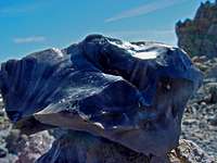
Rocks: Panum’s eruptions produced lava with high concentrations of silica making it very viscous. The lava cooled into several different rock forms. Pumice was formed by explosive eruptions of frothy, molten glass that solidified instantly trapping air bubbles. Pumice is very light and even floats on water. Obsidian, a shiny black rock, is chemically identical to Pumice, but erupted slowly loosing trapped air. It cooled too quickly to form a crystalline structure but formed glassy rock that has extremely sharp edges when broken. Over time, obsidian absorbs water and becomes fine-grained rock.
Hike

From the parking area, a short trail leads to the rim of the crater. The crater is about 2,000 feet across and the prominent rhyolitic dome in the center is visible. You are rewarded with marvelous views to the Easern Sierra Peaks, Mono Lake, and other Mono Craters south of Panum. The trail can be followed around the rim. The rocks that make up the rim are mainly tuff and pumice, which were ejected from the vent at the beginning of the eruption. A short trail leads across the moat to the rhyolite dome in the center of the crater. You can explore the dome at your own pace and marvel at the various rock types and formations. The rim and plug trail is about 2 to 2.5 miles with a total elevation gain of about 200 feet. Collecting rocks and obsidian at Panum Crater or anywhere in the Mono Basin National Scenic Area is prohibited.