
|
|
Route |
|---|---|
|
|
46.48254°N / 12.05356°E |
|
|
Download GPX » View Route on Map |
|
|
Hiking |
|
|
Spring, Summer, Fall |
|
|
Half a day |
|
|
Walk-up |
|
|
Overview
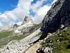
Sentiero (italian for "path") 452 offers a nice hike up to the summit of Nuvolau, enjoying along the way the beauties of the mountain group formed by Nuvolau, Ra Gusèla and Averau. It's not a difficult path, you will be able to reach the Forcella Nuvolau (where the rifugio Averau stands) just by walking along a good path and a wide dirt road. After the Forcella, all you will need to do is turn uphill towards the east/southeast and follow the usual crowds up to the summit. If you feel uneasy when surrounded by so many people, just keep going and enjoy the sights. Croda Da Lago, Cristallo, Tofana di Rozes, Averau and many more will make up for it.Getting There

Passo Giau, the trailhead for this route, is a wide col placed on road SP-638 between the italian villages of Pocol (in fact closer to a neighbourhood of Cortina d'Ampezzo) and Selva di Cadore, about halfway between both. That means about 14 km away from any of them. There's a wide parking area at the pass, but it can get full rather soon during the high season, making it advisable to start the hike early. Apart from private vehicles, there's also a public bus (Dolomiti Bus) that goes across the Pass, linking Cortina d'Ampezzo to the small village of Pescul in the Val Fiorentina.
Route Description
 |
 |
 |
 |
 |
 |
 |
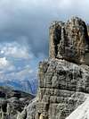
There's an alternative small path (see the .gpx file) you might use to reach the Forcella Nuvolau from sentiero 452. You will be able to see it to your right when the path almost joins the dirt road and you are positioned under the Forcella. Be extremely careful if you decide to follow this tiny path, it's steep, might get tricky if wet and there's a spot where a little bit of scrambling (grade I+ UIAA) could be necessary. If you are not absolutely sure about your ability to cope with this conditions, please follow the main dirt road to the Forcella