
|
|
Mountain/Rock |
|---|---|
|
|
36.55000°N / 118.24°W |
|
|
Hiking, Mountaineering, Trad Climbing, Scrambling |
|
|
Spring, Summer, Fall, Winter |
|
|
13074 ft / 3985 m |
|
|
Overview
*** if you have any images you can add, please do so to help out***
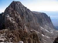
Peak 3985m is located in Inyo National Forest about four miles SE of Mount Whitney. Located on the ridge connecting the Lone Pine Peak and Mount LeConte, Peak 3985m is the most seldom ascended of the five 13ers surrounding the Meyson Lake Basin partly because it is officially "unnamed" and the easiest route to the summit is class 3. Likely first climbed by Norman Clyde, the summit overlooking Meyson Lake to the north and the Tuttle Creek drainage to the south yields excellent views of the surrounding area and nearby peaks.
How to Get There
Peak 3985m is unique in that it is easily approachable from 3 different trailheads.The Cottonwoods Lake trail offers the least elevation gain but longest distance; after gaining New Army pass, follow the trail toward rock creek and establish camp at either Sky-Blue or Iridescent Lake. Then scramble up either of the cols between Irvine-Mallory or Mallory-LeConte positioning oneself for a summit of the west ridge.
Tuttle Creek offers access to four established rock routes on the south face. From the trailhead, follow the trail until it splits from the south fork of the creek and leads up to the stone house. Continue west on the trail until it fades and bushwhack to the base south face of Peak 3985m.
The Meyson Lakes trail offers the easiest access to Peak 3985m; from just below the Whitney Portal, follow the trail up to any of the established campsites (~2 hours); either climb to the Lone Pine Peak plateau to position oneself for climbing the east ridge or to flat area between LeConte and Mallory to do the west ridge.
Routes to the Summit
The easiest routes topping out on 3985m are the west and east ridges. The east ridge approachable from the summit plateau of Lone Pine Peak is class 3; either rappel the ledges along the ridge or drop down early on traverse to the north side of the ridge to bypass these obstacles. The west ridge is more difficult; begin off the ridge to the south and upon gaining climbing a short 20 ft wall stay close to the crest til the summit.
There are at least 4 established rock routes (5.7-5.10a) on the south face; for more information refer to Secor's High Sierra Peaks, Passes, and Trails.
Red Tape
All of the above 3 trails are quota trails meaning permits are required for overnight camping but not for day hiking. Permits may be reserved for $5 in person at either of the Inyo National Forest ranger stations in Bishop or Lone Pine or by calling (760) 876-6200. Since the Cottonwoods Lake trail also leads to the frequently climbed California 14er Mount Langley, it may be more difficult to obtain permits and is advisable to reserve them well in advance. For Tuttle Creek and Meyson Lake trails, walk-in permits (free) are normally readily available on day of entry since these trails are less popular.Camping

In the opinion of this graduate student, Meyson Lake in spring/early summer is one of the most beautiful places to camp in the Sierra. In past experience, there are often kind folk camping here to get away from the Whitney crowds and are more than happy to share a hearty meal with climbers. If doing a big traverse which includes Peak 3985m, usable bivy sites can be found near the summit of Lone Pine Peak but few sheltered sites are located on the ridge between LeConte and Irvine.