
|
|
Route |
|---|---|
|
|
39.56980°N / 106.08482°W |
|
|
Mountaineering |
|
|
Summer |
|
|
Most of a day |
|
|
Hike+Scramble |
|
|
Getting There
Directions to Miners Creek Road/”Peaks Trail” Trailhead:Take Exit 203 on I-70 and turn south onto Route 9. Drive approximately 2.5 miles through the town of Frisco. At the sixth traffic light, turn right onto Peak One Boulevard. After a short distance, you will have to turn right onto a small road (you may see signs for Miners Creek Road/Rainbow Lake Road and can follow them). Cross the bike trail and make an immediate left turn onto Miners Creek road and head south. After a few hundred feet, you will see a parking area/trailhead on the left. I chose to park here because it was not clear to me if I could drive further south on Miner Creek Road, which looked like a bike trail and not a road.
With 4WD, you can drive up Miners Creek Road to 10550 ft.
Route Description
All distances are per my GPSHike south on Miners Creek Rd. The pavement soon ends and you will reach another parking/Trailhead. The tip of Peak 4 is visible from this spot. I chose to continue to follow Miners Creek/Rainbow Lake Road (a trail may provide a small shortcut and bring you back to the road).

After 0.80 miles on the road, you will reach a signed junction for “Peaks Trail” on the left (where the road crosses the creek, you will also see a sign for a spur trail to the nearby Rainbow Lake).
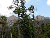
Go on “Peaks Trail and follow it south along Miners Creek. You will be at the bottom of a valley. After a while, the tip of Peaks 4 may come into view when the trees allow it. Peaks 1 & 2 will be much better seen. Ignore the junction with Gold Hill Trail and continue south to reach Miners Creek Trail.
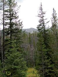
Peak 4
Turn right onto Miners Creek Trail. The trail takes you trough a forest. Peaks 1 & 2 come to view at times.
Peak 1 & 2
You will then reach the end of the Miners Creek 4WD road (Upper Trailhead). Continue on Miners Creek Road. As you go higher, the forest thins out. You will find yourself close to Peaks 3 & 4.

Peak 3 & 4
After you cross the drainage between Peaks 3 & 4, you will note that the trail goes directly up a slope. The trail will eventually take you to a saddle close to a 11984 ft knoll.

Saddle
Before reaching the saddle, you will go above the tree-line. Peak 4 will be directly above you.

Peak 4
You can leave trail and choose your own path up the slopes. I chose to go up to the top of Point 12820 ft.

Point 12820 ft
From there, I followed the broad ridge-top to the summit of Peak 4.
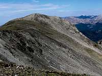
Peak 4