I'm eager to hear any recent information on this trail. Is it accessible still (e.g. no killer fire restrictions)? Are there campgrounds nearby?
I'll be in that area, and was thinking of trying San Antonio from a route that required as little peregrination from i-15 as possible. I hate driving by big cities, and will gladly expend an extra 1000' vertical to avoid traffic.
San Antonio (Baldy) from Wrightwood
8 posts
Page 1 of 1
-

Iron Hiker - Posts: 42
- Joined: Thu Mar 22, 2001 1:00 pm
- Thanked: 3 times in 2 posts
I climbed Baldy for the first time last year via this route. The directions that DougB linked to are pretty accurate. There's only room for 2 or 3 cars at most off the right (west) side of Acorn Dr at its intersection with Finch, and the ground's a little rocky but I didn't have any real trouble parking my car. Just stay on Acorn all the way up to the trail and you shouldn't have any problem with the people who live by it.
For an introduction to Baldy, this was a pretty fantastic hike (a far cry from a Manker Flats intro, I bet....), just be sure you're mentally prepared for all the ups and downs; it's very grueling especially having to go back over Dawson and Pine after already enduring the 1,200' slog up Baldy's north side. The "Other Devil's Backbone" (in my opinion the TRUE D's Bone, as compared to the pics I've seen of the "normal" one on the tourist route up Baldy) on Pine's north ridge is a very interesting scramble and somewhat loose.
Hope you have fun, this is a much less frequented route and gives Baldy some more respect!
-

MoapaPk - Posts: 7780
- Joined: Fri May 13, 2005 7:42 pm
- Thanked: 787 times in 519 posts
Thanks. I was considering staying at the Guffy or Blue Ridge campgrounds ~8000' ... any idea how realistic that might be, if I arrive on a weekday ~3PM? I really just need a legal place to stop a vehicle and set up a tent.


-

Luciano136 - Posts: 3778
- Joined: Thu Jan 19, 2006 11:46 pm
- Thanked: 11 times in 10 posts
Guffy will work (just have to make sure the gate is open). If you are already there, you might as well consider just hiking down the fire road to the base of Pine. It will save you the drive back to Wrightwood in the morning.
-

mtnyoung - Posts: 10
- Joined: Fri Sep 07, 2007 1:11 am
- Thanked: 0 time in 0 post
My wife and my two daughters stayed in Guffy June 13th and 14th (weeknights). We had the place completely to ourselves. We were there because we are hiking the PCT in continuous pieces from Mexico to Canada over a period of years. We got in over 50 more miles. My girls are 8 and 14 years old.
Guffy is a wonderful campground. We live in and frequent the Sierra Nevada, and still thought this was one of the nicest, most "viewful" campgrounds we'd ever stayed in.
While there we also wanted to summit Baldy because it is the LA County highpoint (our other "family fun," long-range activity is trying to summit all the California County highpoints). But we didn't want to drive all the way around to do Baldy's normal route.
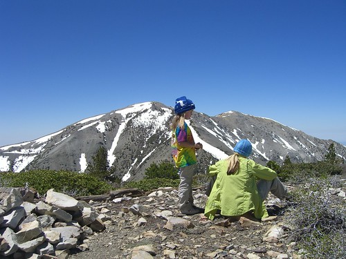
We did Baldy from the north, from Blue Ridge Road, over Pine Mountain and Dawson Peak. (The other advantage of this route (besides us already being within 3 miles of its start) is that we summitted two others of the tallest peaks in the range.) This is 10 miles round trip. There is an established trail, which is obvious, although it is rough enough at one point (for a quarter mile) that I would rate it "Class 2 plus," although, obviously there really isn't such a rating. The drive from the town of Wrightwood would take about 1/2 hour, to the start of the trail. The Forest Service Visitor Center just beyond town has a handout map that briefly describes the hike. It is shown on the topo map I had.
This photo is taken during the first qurter mile of the hike:

From Dawson Peak, looking at Baldy:
Guffy is a wonderful campground. We live in and frequent the Sierra Nevada, and still thought this was one of the nicest, most "viewful" campgrounds we'd ever stayed in.
While there we also wanted to summit Baldy because it is the LA County highpoint (our other "family fun," long-range activity is trying to summit all the California County highpoints). But we didn't want to drive all the way around to do Baldy's normal route.
We did Baldy from the north, from Blue Ridge Road, over Pine Mountain and Dawson Peak. (The other advantage of this route (besides us already being within 3 miles of its start) is that we summitted two others of the tallest peaks in the range.) This is 10 miles round trip. There is an established trail, which is obvious, although it is rough enough at one point (for a quarter mile) that I would rate it "Class 2 plus," although, obviously there really isn't such a rating. The drive from the town of Wrightwood would take about 1/2 hour, to the start of the trail. The Forest Service Visitor Center just beyond town has a handout map that briefly describes the hike. It is shown on the topo map I had.
This photo is taken during the first qurter mile of the hike:
From Dawson Peak, looking at Baldy:
8 posts
Page 1 of 1
-
- Related topics
- Replies
- Views
- Last post
-
- Mount Baldy/San Antonio
by jpgringo » Sun Jan 19, 2020 8:13 pm - 3 Replies
- 3412 Views
- Last post by Josh Lewis

Sun Mar 08, 2020 5:42 pm
- Mount Baldy/San Antonio
-
- Baldy to Wrightwood???
by tkoooooooooo » Mon Jul 12, 2010 9:23 pm - 6 Replies
- 4117 Views
- Last post by Bildonator
Thu Jul 15, 2010 7:41 pm
- Baldy to Wrightwood???
-
- san antonio creek
by norco17 » Thu May 24, 2012 6:48 pm - 3 Replies
- 1326 Views
- Last post by norco17
Sat May 26, 2012 3:45 pm
- san antonio creek
-
- Baldy or San Jacinto
by martinltorres » Thu Jan 31, 2013 11:20 pm - 3 Replies
- 2166 Views
- Last post by Carbo
Mon Feb 04, 2013 10:17 pm
- Baldy or San Jacinto
-
- Mt. Baldy and San Gorgonio Conditions
1, 2by climb4life » Sun Nov 03, 2013 2:33 pm - 23 Replies
- 11714 Views
- Last post by DukeJH
Mon Apr 14, 2014 7:43 pm
- Mt. Baldy and San Gorgonio Conditions
Who is online
Users browsing this forum: No registered users and 0 guests