Hello all. My wife and I are planning a trip to have a go at Gannett peak. We are pretty new climbers but not new to the back country. Our experience mountaineering thus far includes a ten day class and summit of Rainier with RMI in 2012, a failed winter attempt at longs via cables route this past Jan. A successful winter ascent on Mt Washington, a failed attempt of Longs Kiener route last summer due to some crazy storms.
We are advid Trad climbers, backpackers, and outdoors peeps.
Any thoughts/advice??
Planning a trip to Gannett. Any help greatly appreciated
13 posts
Page 1 of 1
-

Bark Eater - Posts: 484
- Joined: Sat Aug 18, 2007 10:04 pm
- Thanked: 109 times in 89 posts
Re: Planning a trip to Gannett. Any help greatly appreciated
Go soon. It appears the snow bridge over the schrund won't be there much longer.
Consider approaching from the east. Bonney Pass is a bitch!
Take your time on the approach and save yourselves for the summit day.
Please let us know how you make out!
Consider approaching from the east. Bonney Pass is a bitch!
Take your time on the approach and save yourselves for the summit day.
Please let us know how you make out!
-

WyomingSummits - Posts: 655
- Joined: Mon Sep 10, 2012 7:03 am
- Thanked: 114 times in 87 posts
Re: Planning a trip to Gannett. Any help greatly appreciated
You can do it from the NW from Green Lakes and approaching up Tourist creek. Then you have options that don't depend on a snow bridge.
-

SgtUSMC - Posts: 8
- Joined: Wed Dec 18, 2013 2:43 pm
- Thanked: 0 time in 0 post
Re: Planning a trip to Gannett. Any help greatly appreciated
Thanks for the replies. Couple more questions......... We were planning to go up the glacier trail side for a short summit day but got to thinking maybe go in Bonney pass side and spend extra day and make base camp over the pass on the glacier?? Is that an option??
We are planning Aug 13-19. 2 or so days in, rest day, summit day, weather day, couple days out so we have some extra time if making base camp past Bonney pass is an option.
We are planning Aug 13-19. 2 or so days in, rest day, summit day, weather day, couple days out so we have some extra time if making base camp past Bonney pass is an option.
-

Matt Lemke - Posts: 734
- Joined: Fri Jan 01, 2010 8:34 am
- Thanked: 163 times in 102 posts
Re: Planning a trip to Gannett. Any help greatly appreciated
I second the option of going on via the green river lakes and up tourist creek. Bet beautiful up there and less people
-
Bark Eater - Posts: 484
- Joined: Sat Aug 18, 2007 10:04 pm
- Thanked: 109 times in 89 posts
Re: Planning a trip to Gannett. Any help greatly appreciated
I wouldn't want to try Bonney Pass from the Titcomb side with a full pack. It's a climb, not a hike. Very steep. There was a lot of very loose scree last week...and that was with still half snow covered.
-
SgtUSMC - Posts: 8
- Joined: Wed Dec 18, 2013 2:43 pm
- Thanked: 0 time in 0 post
Re: Planning a trip to Gannett. Any help greatly appreciated
What's the options for getting past the shrund if bridge is melted out?? Rock climb on climbers left?? How bout coulier on south side of the pinnacle??
-
Bark Eater - Posts: 484
- Joined: Sat Aug 18, 2007 10:04 pm
- Thanked: 109 times in 89 posts
Re: Planning a trip to Gannett. Any help greatly appreciated
Sarge, I'm now relying upon what I've read. Yes, the rock on the left is low 5th class. The couloir route is also an alternative but is a lot more crevassed than the rest of the glacier. Hopefully someone with direct experience can comment. Check out the route page for "Southeast Couloir".
-
WyomingSummits - Posts: 655
- Joined: Mon Sep 10, 2012 7:03 am
- Thanked: 114 times in 87 posts
Re: Planning a trip to Gannett. Any help greatly appreciated
SgtUSMC wrote:What's the options for getting past the shrund if bridge is melted out?? Rock climb on climbers left?? How bout coulier on south side of the pinnacle??
The rock is 5.2-5.5. Very easily passed if you're comfy on rock. The rock can be a little loose.
-

pyerger - Posts: 131
- Joined: Thu Nov 01, 2007 2:05 am
- Thanked: 12 times in 12 posts
Re: Planning a trip to Gannett. Any help greatly appreciated
SgtUSMC wrote:Thanks for the replies. Couple more questions......... We were planning to go up the glacier trail side for a short summit day but got to thinking maybe go in Bonney pass side and spend extra day and make base camp over the pass on the glacier?? Is that an option??
We are planning Aug 13-19. 2 or so days in, rest day, summit day, weather day, couple days out so we have some extra time if making base camp past Bonney pass is an option.
If you have the time, camp in Titcomb basin,and go over bonney on summit day. Titcomb is an awesome place to camp and just hang out for a while I would not want to full pack up Bonney pass, it's tough enough without a pack. If you have an extra day, I highly recommend climbing MT. Helen as well! WY 2nd or 3rd highest peak? Great scramble, on solid rock 3rd class. I love the Green river lakes route up Gannett ( no people, very remote), but I think it is more difficult to climb that way. Although shorter, there is Lots of car size boulder hopping, that will wear you down.
-

triyoda - Posts: 132
- Joined: Mon Sep 04, 2006 3:17 am
- Thanked: 6 times in 6 posts
Re: Planning a trip to Gannett. Any help greatly appreciated
SgtUSMC wrote:What's the options for getting past the shrund if bridge is melted out?? Rock climb on climbers left?? How bout coulier on south side of the pinnacle??
I might have an opportunity to go to Gannet in late August, although it would be a solo trip.
Is there a pretty short window for easy passage across the 'schrund (mid July?). I'd be comfortable on steep snow or even ice up to AI2, but generally not soloing rock rock above 4th class.
The book I have describes describes a northeast ridge and a north face route on 45-50 degree snow/ice, but there isn't a lot of description, like how hard is to get on the route (crossing crevasses). I would figure that by late August there is not going to be much danger of falling in a crevasse, but that doesn't mean there is a viable passage.
I have wind river Mountains (Kelsey), is there a better guide book?
-
markv - Posts: 189
- Joined: Sun May 30, 2004 5:16 am
- Thanked: 3 times in 3 posts
Re: Planning a trip to Gannett. Any help greatly appreciated
My 3 Gannett trips were all in late June and early July, so i'm of no help with the questions about bypassing the 'schrund.
However, after different trips coming in from both Titcomb and Glacier...Glacier got the job done because of the shorter summit day (important because of weather, not because of effort), but Titcomb is what i think back to as the really epic, beautiful route. It's the one i'd want to go back and do again. Personally, i think it's feasible to camp on Night 2 (or night 1 if you're going fast) in Titcomb, then take minimal bivy stuff over Bonney Pass on Day 3. You may do great and make it all the way back to Titcomb without needing to bivy, but you at least have the options of summitting and bivying at the base of the Gooseneck Glacier for Night 3, or at Bonney Pass, or if weather is bad even bivvying first and trying again for the summit the next day.
I know it's a carry over Bonney, but it's not all that long.
But in the end, the surer way to summit is Glacier Trail. (I don't know Tourist Creek.)
-

HeyItsBen - Posts: 364
- Joined: Sat Jan 24, 2004 3:22 am
- Thanked: 9 times in 9 posts
Re: Planning a trip to Gannett. Any help greatly appreciated
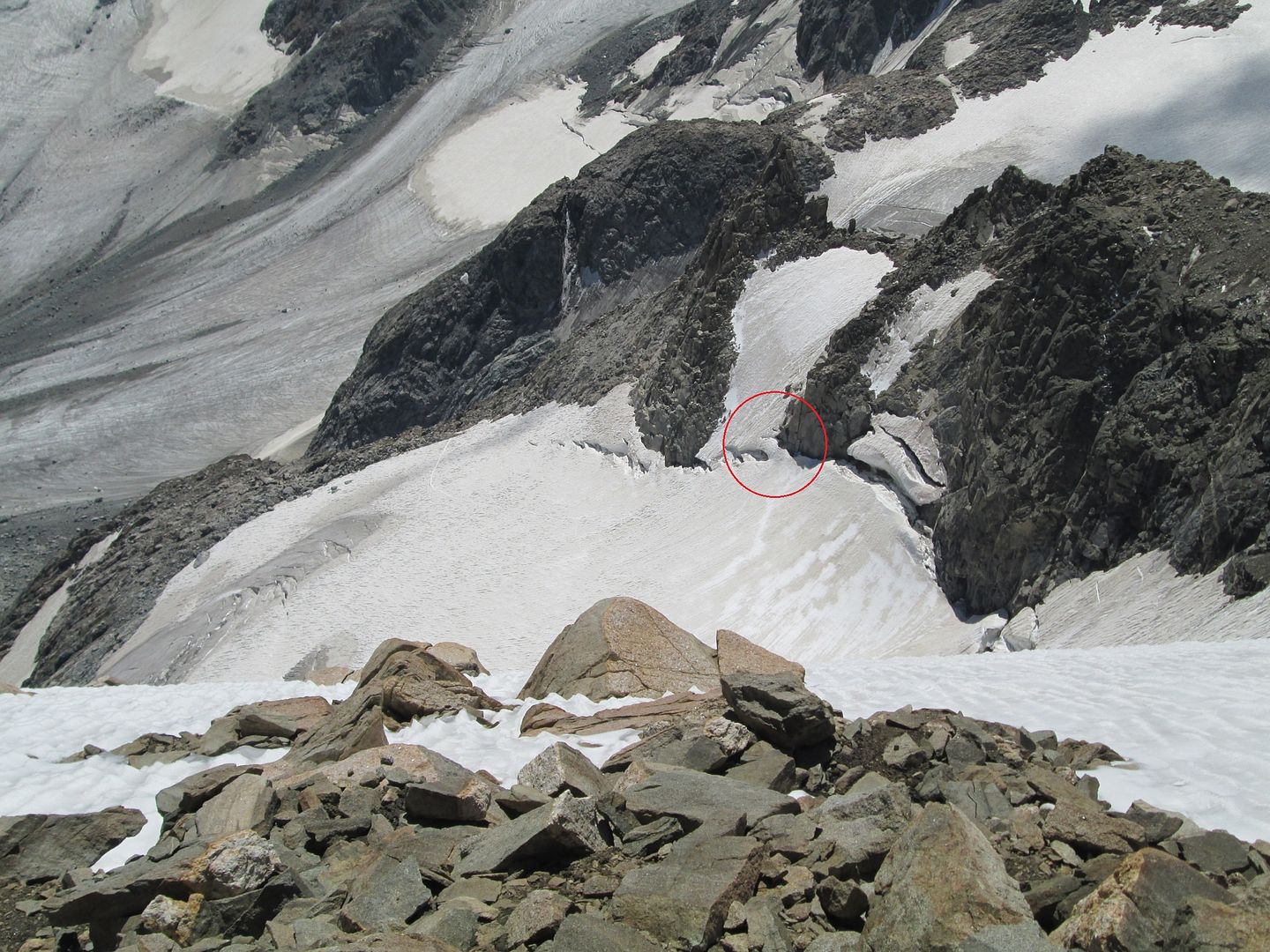
Climbed Gannett on Aug 10th. The 'schrund was easily passibly on the right side, I circled the bridge in a photo taken from near the summit. Pretty steep for about 15 feet, but the bridge was nice and thick, I can't imagine it being a problem anytime soon. Rap slings to get back down looked fresh, I suspect placed by a party that summited the previous day. What an awesome area...
13 posts
Page 1 of 1
-
- Related topics
- Replies
- Views
- Last post
-
- Gannett Granite Tetons trip - late june 2010
by arm » Fri Apr 16, 2010 11:39 pm - 8 Replies
- 4406 Views
- Last post by Doublecabin

Fri May 14, 2010 12:19 am
- Gannett Granite Tetons trip - late june 2010
-
- Gannett Peak Wind Rivers trip August 24-2
by Murock » Wed Aug 19, 2015 10:24 pm - 6 Replies
- 4541 Views
- Last post by Bark Eater
Fri Aug 21, 2015 6:13 pm
- Gannett Peak Wind Rivers trip August 24-2
-
- Gannett Peak in May?
by RangerJoe224 » Thu Mar 31, 2011 9:23 pm - 3 Replies
- 2942 Views
- Last post by splattski
Sat Apr 02, 2011 1:18 pm
- Gannett Peak in May?
-
- Gannett 2011
by Monopole » Thu Jul 07, 2011 1:28 pm - 11 Replies
- 3682 Views
- Last post by Clark_Griswold
Wed Aug 17, 2011 6:06 pm
- Gannett 2011
Who is online
Users browsing this forum: No registered users and 0 guests