
|
|
Mountain/Rock |
|---|---|
|
|
43.77804°N / 3.81020°E |
|
|
Hérault |
|
|
Hiking, Mountaineering, Trad Climbing, Sport Climbing, Mixed, Scrambling |
|
|
Spring, Summer, Fall, Winter |
|
|
2159 ft / 658 m |
|
|
Overview

Summit

Peak from the castle

Limestone chaos

Montferrand Castle

L'Hortus

Pic Saint-Loup

L'Hortus
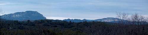
Pic de Saint-Loup is the emblematic mountain of the French city of Montpellier. Seen from everywhere in the skyline, it is the very first noticeable feature of the Montpellier's backcountry, the foothills of the Massif Central, southernmost of the Cévennes. Visible from most of the seaside as well as the Hérault department, it reminds somehow the way Sainte Victoire announces the Provence over Aix.
Despite its very modest height, 658m, its stretched shape from east to west, between Cazevieille and Saint-Mathieu-de-Tréviers presents jagged limestone features all over its lenght, and even impressive vertical cliffs, sometimes more than 300mh, on the north face. Due to the fact the rest of the relief doesn't exceed 150m of height, the mountain is very prominent. The harsh low vegetation that covers most of it, without the too dry and rocky upper part confere it an even more alpine look. Holm oaks, Kermes oaks, Aleppo pines, arbutus, juniper, thyme, bay leaves, juniper, rosemary, rock rose are found. The whole site is protected and hosts numerous raptors.
The summit of Pic Saint Loup hosts an ermitage, and old chapel, a cross, and a dodgy broken watchtower. But the most interesting historical feature that the mountain hosts is located below on a secondary top of the east ridge, around 400m of height. The ruins of the Montferrand castle stand there since 1108 ! Visiting it is quite dangerous: beware of gaps in the cellar.
It is connected on the north by another cliff-shaped mountain, l'Hortus (512m), describing a wide curve. A wide pass, Fambétou, served by a road , separates them, and makes a good trailhead. The views from l'Hortus towards Pic Saint-Loup are particularly gorgeous and allow admiring the mountain in all its splendour.
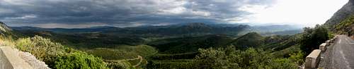
From the top of Pic Saint-Loup itself, the views extend until the Cévennes and the Grands Causses. All the coast, the city of Montpellier are visible as well on the south. Wind is usually very strong and for this reason the area is famous for gliding.
Pic-Saint-Loup finally refers very often, not to say even more when looking at the web, to the region of wine producers in the neighbourhood of the mountain.
But the etymology of the peak does not come from wine neither the opposite. Three vaillant knights, Guiral Clair and Thieri Loup were in love with the beautiful Bertrade; the one that would marry her was to be designated as the bravest after the saint war. All three came back with high feats, but unfortunately the beautiful Bertrade had died meantime. Desesperated, they all retired to a mountain. Guiral went to mont Saint-Guiral (near Aigoual), Clair to mont Saint-Clair (near Sète), and Loup to Pic Saint-Loup. Each year, on March 19th they lightened a fire on top to celebrate her. Saint-Loup is the one of the three that lived the longest.
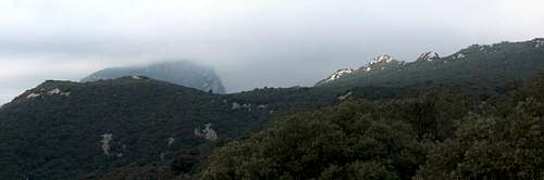 East Ridge under the clouds
Routes

South slope

L'Hortus from top

Castle from the top

South view

Cliffs of L'Hortus

Easy hike...
1/ South trail (normal route)
From both Cazevielle or Saint-Mathieu-de-Tréviers, linked each other by a red-marked large trail (GR60), we reach under the summit another secondary trail that climbs to the top, in many laces.
2/ Eastern ridge
This hike is more detailled here (french), and is for confirmed walkers with a good physical condition. The path starts at the road pass of Fambétou, under L'Hostus, and follows a red-marked trail that reaches the east side of the peak.
The east ridge is followed until the top, which we pass. The descent is made via a marked path that suddenly plunges on the right. The main path of the approach earlier is met later.
3/ Northern diagonal
This hike is more detailled here (french). It is particularly exposed, with scrambles needed (II UIAA), and despite the very modest height of the peak, this is for confirmed mountaineers. It must be done by dry weather and good visibility.
It consists in reaching the north face of the peak, the steepest as we see it in the horizon, from the central pass of Fambétou (under L'Hostus) and the forest. The trail follows a corrie that is named "Cirque des Escargots" and its diagonal. There is a recent red marking which should avoid getting lost.
4/ The ridge of L'Hortus
The small brother of Pic Saint-Loup also has a trail worth mention running along its ridge. The first part from the road pass is red-marked, but the rest is made offtrails. As we meet bright green marks on the right, slightly before we overlook the hamlet of "Labau", we climb down the east steep slope until a land-rover track that runs under the cliff and parallel to it. This track reaches back the road pass. The views to Pic Saint Loup are stunning all along the hike.
5/ Tour of the Pic Saint Loup (mountain-biking)
Description on MBPost...
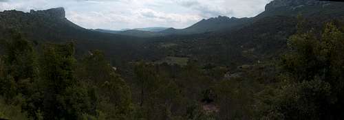 View from pass Fambétou
Getting there


Montpellier is reached either from Marseille or Toulouse on the A9. Take the exit 29 (Vendargues) when from Marseille, and 30 (centre) or 31 (west) when from Toulouse.
Use the D21 to Castelneau-le-Lez that circumvents the centre via the east, then the D86 till Clapiers, then the D17 heading North that we keep until Saint-Mathieu-de-Tréviers, the usual trailhead. For other starting points, please refer to the little map below.
The drive doesn't take more than 25 minutes from Montpellier.
View Larger Map
 On the road
Red Tape

South view

Small trail
There is no particular red tape, and the Pic Saint-Loup does not belong to any protected area of any sort.
However, even if wildcamping is in theory not forbidden, given how dry are the climate and the vegetation here, fires are strongly not recommended.
Even if you start one for sausages without causing a forest fire, firemen are likely to pop out from nowhere, and you may have to pay a fine...
 In the skyline...
Accomodations

Houses from the top

Wineyards

Southern atmosphere

Southern atmosphere
- Wildcamping and bivouacking are in theory not forbidden. However, the mountain is small, and in this region almost all piece of land belongs to some domain. Wildcamp only in the upper part of the hill (and read the red tape).
- One official campsite in Saint-Martin-de-Londres. (the closest. Others are nearer Montpellier).
- A crowd of accomodations (but often of high touristic standard - not basic mountaineering standard) in the area. For example : Mas de Pierrefeu
Map

Pic Saint-Loup from L'Hortus track

Lapiaz chaos...
Numeric maps
Due to the copyright policy of the IGN, it is not possible to scan and include map samples without permission. The only way to consult them online is via the database Géoportail, easily browsable via the site ClicGPX (we need to unzoom, move to the Montpellier region and rezoom again)
Paper maps
The TOP 25 series of IGN, high quality maps at the 1/25000 scale, is mandatory for hiking offtrail on Pic Saint-Loup. The map that covers the area is 2742ET (Ganges/Pic Saint-Loup/Saint-Martin-De-Londres). See the France index for a more accurate look and the neighbouring regions.
External links
www.loupic.com, associative portal about the region (french). Some topos in it.
randonnee.cevenole.free.fr, a very good local ressource of easy and harder hikes, mostly in the Cévènes, but covering also Pic Saint-Loup and its region.