
-
 7368 Hits
-
 88.61% Score
-
 27 Votes
|
|
Mountain/Rock |
|---|---|
|
|
42.37858°N / 8.90736°E |
|
|
Corse, Corsica |
|
|
Mountaineering, Trad Climbing, Scrambling |
|
|
Summer |
|
|
7372 ft / 2247 m |
|
|
Overview
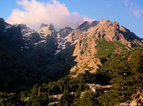
Pic von Cube 2247 m
The Haut-Asco area, located in the Northern sector of Corsica, is covered with luxuriant pine forests and it's plenty of little lakes; this peculiarity gives to the landscape an alpine look, with peaks over 2.000 m. that suddenly fall away into the sea. The impressive Asco Valley, surrounded by stunning peaks and cut through by the thundering Asco river, which flows with crystal clear waters through the cliffs and gorges, giving its name to the valley, penetrates within the heart of this wild region. The Haut–Asco is one of the finest mountain region of Corsica and here is located the highest summit of the island, Monte Cinto m. 2706.

Pic von Cube, formerly named Punta Rossa, is another superb peak, the last important one before Punta Minuta, from which it’s separated from Col Perdu or Bocca Tumaginesca in Corsican dialect. It’s a mytic mountain and its name pays homage to Felix von Cube, one of the greatest pioneer of the Corsican mountains. There are different climbing routes on this fascinating peak.

The approach walk is beautiful but rather long, in reason of the lack of shelters situated nearby the peak.
Getting There

Corsica can be easily approached:
- by ferry-boat from the French ports of Marseille, Nice and Toulon or from the Italian ports of Livorno, Genova and Savona (main Corsican ports are Ajaccio, Bastia and Calvi). The shortest trip by ferry is from Livorno port on Italy Western coast to Bastia port on Corsica Eastern coast.
- by plane; main Corsica airports are Bastia, Ajaccio, Calvi and Figari.
Road approach
The most convenient destinations to visit the haut Asco is Bastia. The closest town to the Asco Valley is Ponte Leccia.
- from Bastia (Corsica East coast) take the road to Corte and Ponte Leccia
Road approach to Haut-Asco
From Ponte Leccia follow the road N197 to Calvi and after 2 km leave the main road and turn to left, taking the road D147. Drive to South-West on the narrow and impressive road, penetrating within the Asco valley. After about 18 kms you will reach the small settlement of Asco m 600, the unique village in the valley; the road penetrates within the beautiful Forest of Asco and after some hairpins reach the ancient ski-station of Haut-Asco m 1422 on the Stagnu “plateau”. Parking.
Approach walk
From the Haut-Asco station head to SW, walking along the ancient ski-track to reach the GR20 red and white marks, rising inside the "pino laricio" forest. On the large "plateau" the path joins the GR20 coming from Stranciacone Col. The good path follows the valley, then head to left, reaching the small Lac Perdu.


To climb the SE side routes follow again the GR20 rising along the rocky and snowy slope, heading towards right to reach a rocky notch just below the SE ridge. To climb the NE ridge leave the main path near Lac Perdu and climb the scree on the right to the starting point of the route.
Pic von Cube routes overview
Pic von Cube South East Ridge Bavarian Route report (UIAA scale)
Summit altitude: m 2247
Difficulty: Alpine D, V UIAA
Route length: 150 m
Difference in level: 1000 m from Haute-Asco Stagnu
Exposure: South-East
First ascent: W. Fursicht - T. Hartl 1968, June, 6th
Starting point: Haut-Ascu Stagnu m 1258, upper Asco Valley
A beautiful airy ridge on excellent rock well visible from Col Perdu. A wild environment.


Approach - From Haut-Asco head to SW, walking along the ancient ski-track to reach the GR20, rising inside the "pino laricio" forest. On the large "plateau" the good path joins the GR20 coming from Stranciacone Col, follows the valley and then heads to left, reaching the small Lac Perdu. From here follow again the GR20 rising towards Col Perdu along the rocky and snowy slopes; before getting to the Col Perdu, leave the main path, head towards right and scramble up to reach a rocky notch just below the SE ridge. Starting point near a huge Boulder.
L1 - Slanting left climb the crack located on the left of a long corner (this latter is the first pitch of the Swiss route) and reach a good stance, IV- UIAA, 25 m.
L2 - Climb up the steep wall over the stance, at first heading a bit towards right, then directly. Go round a ridge, climb a smooth slab and reach a stance at the base of a dihedral, V, 50 m.


L3 - Up a sequence of dihedrals and little walls along an edge to a stance under the ending wall, IV, 45 m.
L4 - From the stance climb towards left to take a long and wonderful groove exiting to a shoulder. An easy and short ridge leads to the summit cairn, V-, 40 m.


Descent: along the Normal Route on North West Ridge
From the top downclimb (II UIAA) towards the saddle located between the main summit and a secondary one. Reach the saddle, then traverse right and keep the right side of the ridge (facing out), reaching another notch. Pass on the left of the ridge, skirt it and after another short downclimb (II UIAA) reach a saddle. Turn to right and walking down a scree reach the approach path (GR 20) just near the little Lake Perdu.
Other routes
-SE Face Via Nerli AD-
-SE Ridge - Swiss Route D, 150 m - F. Widmer and R. Wittmann 1966
-NE Pillar D+, 200 m. - T. Mayer and J. Krumpschmid 1970
-NW Ridge or Normal Route PD- - Otto Schlaginweit and Otto Vollnhals 1902, October 18th
Descent: from the summit downclimb easily (max II grade UIAA) to reach the saddle separating the two summits of the mountain. From here walk up to the NW in the direction of a crest and skirt it, then climb up on the summit of the crest, follow it with an easy downclimb (max II UIAA) ridge. At the end of the crest oblique to the NE (right) and walk down on a slope leading to the Lake Perdu, from which follow the same itinerary of the approach.
Red tape
No fees no permits needed. The Haut-Asco area is located inside the Parc Naturel Régional de Corse P.N.R.C. (Natural Regional Park of Corsica), which has been acknowledged as “Great National Site” since the year 1985. Its 33,000 hectares' extension includes 143 communes and fills beyond 1/3 of the island’s territory. Be aware that wild camping is strictly prohibited in Corsica.
Nature and climate

Nature is wild and peculiar; in Corsica we can find more than 5% of authoctonous kinds of flower and plants, in addition to authoctonous fauna. On the contrary, several kinds of animal current inside Mediterranean countries are away from Corsica, like squirrels and vipers. Climate in Haut-Asco is alpine, with cold and very snowy winters. Summer usually is pleasant, though sometimes it can be hot when climbing on South faces.
When to Climb
Best season goes from middle June to middle October
Accomodation

- Hotel Restaurant Gite "Le Chalet" - Haut Asco - Refuge Stagnu - Haut Asco
- A couple of hotels in Asco
Campsites
At Haut-Asco basic camping is possible, otherwise there are different equipped camp-sites along the Asco Valley; the closest is Monte Cinto Camping, located within the Haut Asco Forest, between Stagnu and the village of Asco
Meteo
METEO CORSE
LACHAINE METEO ASCO
Guidebooks and maps
-Guidebooks


"Guide d'escalade en Corse - Corse du Nord", Tome I by Jean Paul Quilici and Bernard Vaucher, Ed. de l'Envol, 2000, in French
"Corse, l'ile verticale" by Martial Lacroix e Pierre Sanchou, Ed. Adrénaline, 1999, in French. A selection of 72 beautiful multi-pitches in Corsica, in French
"Corse paradis de l’escalade" by Martial Lacroix, DCL Editions, in French
- Maps
IGN OT4250 "Monte Cinto" 1:25.000
Corse du Nord 1:50 000, Ed. Didier Richard, map 20