
|
|
Route |
|---|---|
|
|
46.91806°N / 121.46755°W |
|
|
Winter |
|
|
Half a day |
|
|
Snow climb |
|
|
Overview

The Pickhandle Basin Route is a highly recommended route for anyone trying to attempt Pickhandle Point. The route is a great winter route because it goes over diverse mountain terrain has a reliable trailhead accessibility and starts off at a high elevation. Like most summits in this area the elevation gain here is around 2500 feet, which makes the mountain very doable even in deeper snow situation. Add on the stellar views of Mount Rainier and you a clear winner snowshoe route in the Cascades.

Getting There
VIA THE CRYSTAL MOUNTAIN SKI AREA: From Enumclaw take 410 east for 33 miles until just before reaching the gate of Mt. Rainier National Park. In winter this road will be gated just passed the Crystal Mountain Road. Make a left on Crystal Mountain Blvd (7190) (paved) go roughly 6 miles to the main ski area.Note: In summer you can take the F. S. R. road roughly 1.8 miles from the ski area and take it up to the Bullion Basin Trailhead at 4800 feet. The road is rocky and steep (4WD highly recommended) and a Northwest Forest Pass is required.
Route Description
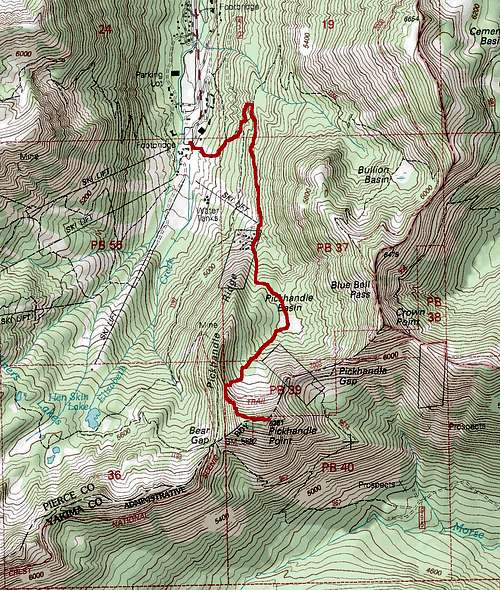
The best way to reach the mountain is by Pickhandle Basin which lies in between Pickhandle Ridge and Crown Point. I personally tried the ridge in two feet of snow and did not make it. In winter you can either go up the ski lift when the ski resort is closed or by the side trails to the left of the ski area. Once at the top of the ski area you want to make a right and take the well groomed snowmobile into what looks a vacation home or rental area. Once at the base you can either continue head up the road to a steeper gully or take a lower road and head over the bridge where once you get to the base of the steep forested hill you head up.
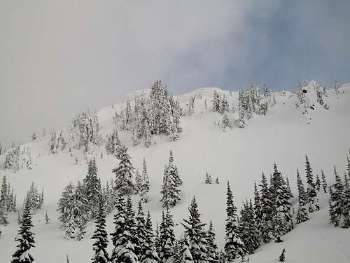
Head up the slope or gully to Pickhandle Basin. Some try the ridge but it is much easier if you head for the basin instead. Pickhandle Basin is the obvious open field which lies between Pickhandle Ridge and Crown Point. From there look for a stream area on your right that is head uphill in the south facing direction. Take this forest gully all the way up to another smaller basin at about 5900 feet. Ideally for the easiest route you will want to head to the right to attain the lower part of the ridge and then take the more gradual rise to the summit. On our successful trip we went up to the left and attained the summit on a much steeper slope.
Essential Gear
The gear recommend for this winter route up Pickhandle Point is an ice axe, traction devices, snowshoes and trekking poles. As with any hike and climb your ten essentials are required as well. An avalanche beacon is recommended for this climb and an backcountry trip in the Crystal Mountain area.External Links
The best page to find local weather and local conditions on Pickhandle Point and neighboring mountains in the region.The best website for trip report on Pickhandle Point and other Cascade Mountains in the region.