
|
|
Area/Range |
|---|---|
|
|
37.38400°N / 118.67257°W |
|
|
Hiking, Trad Climbing, Sport Climbing, Scrambling |
|
|
Spring, Fall |
|
|
7000 ft / 2134 m |
|
|
Overview
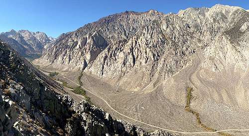
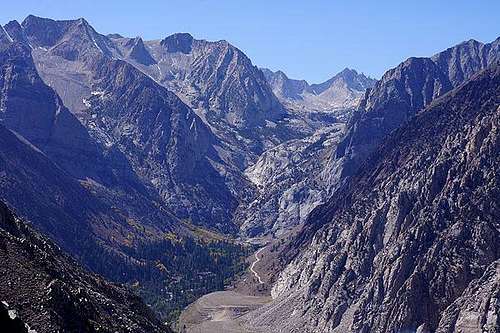
View of Pine Creek Canyon from the NE ridge of Mt. Tom
Pine Creek Canyon is a large valley located on the Sierra Eastside of California, bordered by the spectacular Wheeler Crest to the North and striking Mt. Tom to the South. Easy access from Bishop (20min) and Mammoth Lakes (40min) make it a favorite of locals, but it is overshadowed as a destination by Owens River Gorge just a few miles down the hill. Pine Creek is home to many recreational opportunities, including climbing, hiking, cycling (road), fishing, and horseback riding. It also has a long standing history of mining, although the tungsten mine at the end of the road is currently dormant.
CLIMBING:
Climbing at Pine Creek dates back to the late 1960’s, although it is quite conceivable that earlier first ascents by notables such as Norman Clyde and Smoke Blanchard may have been done. In recent years there has been a surge of new route development by Eastside locals and others, resulting in the establishment of many fine routes ranging from moderate to hard and short to multi-pitch. The climbing is on granite that varies in quality from excellent to fair and slabby to vertical. There is a good mix of sport and trad routes. Two main areas exist (PSOM/Scheelite and Pratt’s Crack), but numerous other cliffs have been developed (Three Hour Buttress, Crack of Noon Buttress/Fashion Slab, etc.).
HIKING/BACKPACKING:
A drive to the end of Pine Creek Canyon leads to a dirt parking lot and trail head at the pack station. Skirt around the right side of the pack station to find access to the Pine Creek/Italy Pass trail. The main trail forks after approx. 5.5 miles, leading West to Granite Park/Italy Pass and South to Pine Creek Pass and French Canyon/Humphreys Basin. The first two miles up to Brownstone Wall are rather steep.
An initial, separate side trail leads South to Gable Lakes.
The Upper Canyon: a juxtaposition of full fall glory and remnant tailing ponds...
Morgan Pass Trail Head
The scenery is magnificent (if one ignores the mine below) and the hikes are challenging.
A good overview map of all three trails can be found here: http://www.fs.usda.gov/Internet/FSE_DOCUMENTS/stelprdb5337632.pdf
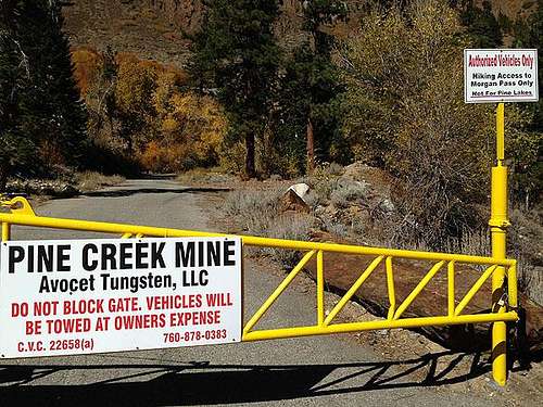
Following the road past the yellow gate leads North up to Morgan Pass (the hard way).
CYCLING (ROAD):
Pine Creek is a great ride due to low traffic, great scenery, and a relatively moderate grade (5-6%, with a few steeper sections and even a short, shallow downhill). The steepest part is coming up to and past a couple of switchbacks approx 2.5 miles up the hill from the town of Rovana. Slow for these curves on the descent! The ride is featured in the Everest Challenge, a two-day sanctioned stage race that also has a public division for those who’d like to ‘just finish!’
HORSEBACK RIDING/PACKING:
Day rides and pack trips can be arranged through the Pine Creek Pack Station at road's end. Contact: 760-387-2797
Getting There
From the junction of Hwy. 395/6 on the Northeast end of Bishop, CA drive just shy of 10 miles West/Northwest on Hwy. 395 to the Rovana exit. Turn West (left) and follow Pine Creek Road for 3 miles to Pine Creek Village/Rovana (no services, SLOW - 35mph!). Continue West out of town, cross the creek and pass a couple of switchbacks. A bit further the canyon unfolds in front of you and the climbing becomes visible to the NW (right). For hiking trailheads continue up the canyon and park in a large dirt area on the SW (left) side just shy of road's end (yellow gate at the mine, around 6.5 miles from Rovana).
Red Tape
There are a number of restrictions for overnight trips, including permits, quotas, group size, campfires, etc. Contact: (760) 873-2483 for permit information. More information can be found here: http://www.fs.usda.gov/recarea/inyo/recreation/recarea/?recid=20370&actid=51
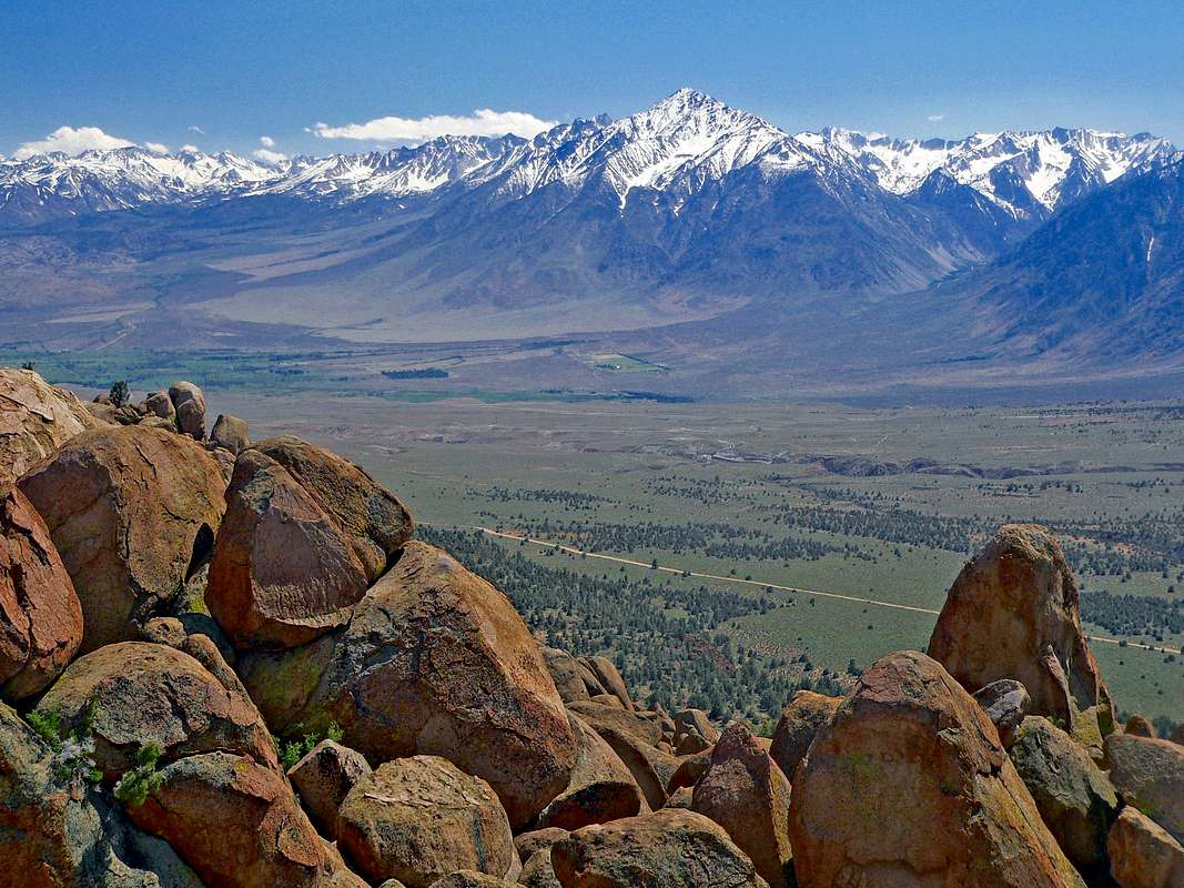
Deer Migration: Pine Creek and the surrounding area is a winter habitat for mule deer. We've all seen deer crossing signs along the road side, but this is different: there are literally thousands of them and depending on the season you can easily see 50 or more deer right next to the road, casually crossing the road, standing in the middle of the road, etc.
More information can be found here: http://eslt.org/Pages/mule-deer-migration.html
Lightning: The Sierra experiences thunderstorms during the summer and Pine Creek is no exception. Due to the fact that most climbing in Pine Creek is East or SE facing, around 7,000' in the valley/canyon, and surrounding peaks and ridges are in the 10,000'+ range, thunderstorms and storms in general have a habit of sneaking up on climbers.
Rovana: this is a tiny town, a few streets, a bunch of houses, with dogs and kids running around. There's no need to roar through here. The speed limit is 35mph and going even less than that will get you to the crag only a few seconds later. Slow down!
Bighorn Sheep: there are a number of bighorn in Pine Creek Canyon and the surrounding area. Tread lightly!
Season
The best time to climb in Pine Creek is Spring and Fall, but it is possible to climb there year around (especially if it's a mild winter or relatively cool summer day). Most of the crags face SE or East.
Camping
There is limited, undeveloped camping on the SE side of the road near Pratt's Crack turn-off.
Resources - Climbing Information
- Bishop Area Rock Climbs, 3rd edition, 2008 by Peter Croft and Marty Lewis, Maximus Press, ISBN: 0-9676116-9-3; a good introduction to Pine Creek, but rather dated
- The SierraEast Side, by Alan Bartlett and Errett Allen, 1988; ISBN 0-934641-11-0; out-of-print, but an excellent resource if you can get your hands on one
- Climber's Guide to Pine Creek, by Tai DeVore, et al., work in progress/expected publication 2018; Tai and his co-workers at Eastside Sports can provide much of current Pine Creek information during non-busy times
Resources - Other Information
- The Complete Guide to Climbing (By Bike) in California, 2nd edition, 2014 by John Summerson, Brigham Distributing, ISBN: 978-0-9792571-4-8; excellent resource for those who enjoy the uphill part of road cycling- Mine in theSky by Joseph M. Kurtak, 1998; ISBN-13:978-1888125344; out-of-print, but an excellent resource if you can get your hands on one (library or $100+ on amazon)
- The Story of the Pine Creek Tungsten Mine; Rock Creek message board post, fascinating (if you're into a bit of history)
Resources - Stores
- Eastside Sports, 224 North Main St., Bishop, CA 93514; Phone: 760-873-7520; http://eastsidesports.com; excellent selection of hiking, backpacking, and climbing gear; mostly regular retail prices, some sales- Mammoth Mountaineering Supply/Gear Exchange, 298 North Main St, Bishop, CA 93514; Phone: 760-873-4300; mix of new and used/consignment climbing, backpacking, and back-country skiing gear; not as extensive as the Mammoth Lakes store; reminiscent of the former Wilderness Exchange in Berkeley, CA
- Sage to Summit, 312 North Main St., Bishop, CA 93514; Phone: 760-872-1756; http://www.sagetosummit.com; excellent selection of trail, ultra-running, and fast-packing gear
- Mammoth Mountaineering Supply, 3189 Main St., Mammoth Lakes, CA 93546; 888-395-3951; http://mammothgear.com; excellent selection of hiking, backpacking, climbing, and back-country skiing gear; regular retail prices, some sales