
|
|
Mountain/Rock |
|---|---|
|
|
32.86318°N / 108.24136°W |
|
|
Grant |
|
|
8127 ft / 2477 m |
|
|
Overview


Pinos Altos (Spanish for "tall pines") Mountain, with an elevation of 8,127 feet and prominence of 1,187 feet, is the highest summit in the small Pinos Altos Mountains (not to be confused with the nearby and larger Pinos Altos Range) in southwestern New Mexico. The summit is located one mile due west of the town of Pinos Altos and about 6 miles north of Silver City, just beyond the borders of the Gila National Forest. This is one of two summits in this range that has a road leading to it, the other being Point 7609 one mile to the south.
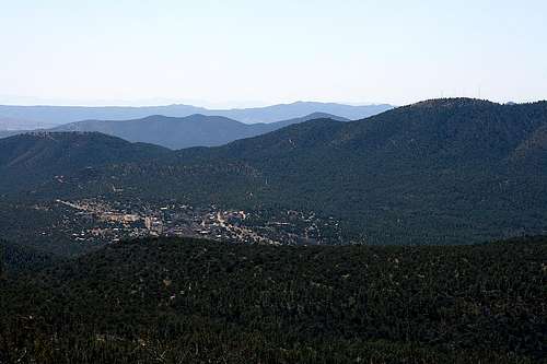
There are several radio towers and maintenance buildings on the summit. To reach the actual summit, there is some simple and minor bushwhacking required as it is located on a small rock outcropping amidst some brush. From the summit, you can look 1,100 vertical feet down to Pinos Altos. No other summit in the area offers this kind of view of this historic mining town that dates back to 1860. There are also great views to be had of much of the Pinos Altos Range including Black Peak, which at 9,029 feet in elevation, is the high point of that range.
Getting There
From U.S. Highway 180 just east of Silver City, take NM Highway 15 north for about 6 miles. About 0.3 miles south of Pinos Altos, turn left (west) onto the dirt road (marked “Radio Tower Road”). You will need to travel about 2.1 miles on this road to reach the summit. After going about 0.8 miles on this road, it will split -- stay to the left. 0.4 miles later, stay to the right where the road splits again. You will come across two intersections to the right that are closely separated. Both of these lead to Pinos Altos Mountain, but the second intersection is probably smoother traveling. Turn right here, then stay to the left at the next intersection and stay to the right at the one after that. There is one final intersection very close to the summit; I stayed to the left but I don’t think it matters.A high clearance 4WD vehicle is a must for this route. Once you turn right at the two closely-separated intersections, the road gets much steeper and very rough with large rocks.
NOTE: Topographic maps do not show some of these 4WD/maintenance roads, such as the two closely-separated intersections mentioned above.