
-
 31216 Hits
-
 80.49% Score
-
 12 Votes
|
|
Route |
|---|---|
|
|
47.32740°N / 12.61462°E |
|
|
Hiking |
|
|
Spring, Summer, Fall, Winter |
|
|
A long day |
|
|
Easy walk / summits a few steep sections |
|
|
Intro
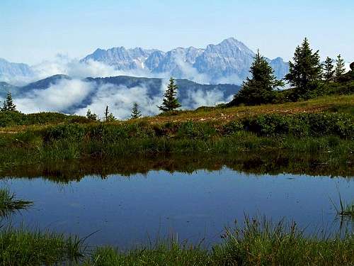
The view on Birnhorn from Kesselscharte
Surrounded by such beautiful mountain areas as Hohe Tauern and Zillertal Alps on the south, Kaisergebirge and Steinberge on the north and north-east, Kitzbuehl Alps are somewhat less attractive for mountaineering. No super-summits, no big walls, just a hilly, rounded mountain landscape. So, it's a primarilly hiking area and in winter a broad tour skiing area. No wonder why Kitzbuehl is a Mekka of world skiing.
The southern border of Kitzbuehl Alps nevertheless consists of two streaks of nice peaks, which first of all offer great vistas on Zillertal Alps and Hohe Tauern. The eastern streak stretches from Pass Thurn to Zell am See and over the big part of it runs the famous Pinzgauer Spaziergang (walk). It is really an easy, but long walk, on which we can for a whole day enjoy marvellous panoramas. Well, it is easy technically, but if we ascend additionally one or two major summits along the trail and if we do the hike by fair means, so returning back with a bike for example, then it turns into a nice one day tour.
 The start |
 The trail |
Geography
From the east towards the west the main geographical features are the following: With cable-car you reach Schmittenhoehe, 1965 m. Next is Kettingtoerl, 1780 m, then a flat Kettingkopf, 1865 m, comes. Next to it is Kesselscharte, 1844 m, and above it Maurerkogel, 2074 m. The next saddle is Roehrertoerl, 1918 m, above it there are the Oberer (2175 m) and Niederer (2163 m) Gernkogel. The next notch is Klammscharte, 1993 m, with Zirmkogel, 2215 m, above it. This is the area of so called Hochsonnberg, which ends on the west with Klinglertoerl, 2059 m. Towards the west the highest summit (not counting Geisstein, of course) rises: Hochkogel, 2249 m. West of it is the sharp Hochsaalbachkogel, 2212 m, and more to the west Medalkogel, 2123 m. It descend down to Medalscharte, 2058 m, after which a similar trio rises: Sonnberg, 2187 m, Baerensteigkopf, 2225 m and Lamperbichlkogel, 2036 m. SE of Baerensteigkopf is its fore-summit Baerensteig, 2210 m. This group ends with the broad Sommertor, 1939 m. West of it the last high summits are rising: Rabenkopf, 2074 m, Manlitzkogel, 2247 m, Zehetner Stange, 2114 m and Mittagskogel, 2092 m. Finally there is the Murnauer Scharte, 1959 m, where our route descends to the valley. Beyond this saddle is aleady the Geisstein group.
General
The Character
From 1965 m to 1699 m, 24 km, not much ups and downs on the trail - it goes surprisingly well horizontally, you keep the height of cca 1950 m - 2000 m, all the time above timberline. Well beaten path and well marked (No. 719) - Pinzgauer Spaziergang is in its course identical with the long-distance hike, called Arnoweg, marked with 02A. Very panoramic, so make sure the weather is good!
Logistic

Mittersill
You reach the Pinzgau valley (Zell am See, Mittersill) from the highway Salzburg-Villach, exit Bischofshofen, driving towards the west. From the west you get there from Innsbruck via Mayrhofen and Gerloss Pass. From the north you get there from Kitzbuehl over Pass Thurn. And from the south you get in Pinzgau by any of the three options of crossing Hohe Tauern. You can see a detailed map (1:50.000) on-line on: http://www.austrianmap.at/.
You best do the hike from the east towards the west. So, you start in Zell am See and ascend Schmittenhoehe with the cable-car. The bottom station is in the Schmittental, a broad valley just west of Zell am See, 2 km away from the town centre and 180 m higher. There you leave your car. The cable-car drives in summer each half an hour from 8:30 till 17:00. The cost is 16€ (2007). After completing the hike on the western end, at Buerglhuette, 1699 m, you need to return to Zell am See and the parking lot. The options are:

We shall return in Zell am See with bikes
> Bike (most recommendable). You can reach Buerglhuette by car and leave bikes there. From the hut down to Stuhlfelden in the main Salzach valley you have 10 km of a mountain road and you lose 900 m of altitude. From Stuhlfelden you bike 25 km to Zell am See, you lose another 150 m, only a few short ascents on the course. And finally from Zell am See 2 km up to the parking lot, you ascend 180 m. For the whole biking part of the tour count some 2 h 30 min.
> You walk down to Stuhlfelden (2 h 30 min), there take either a train or bus to Zell am See.
> You take the hut-taxi to Stuhlfelden, there switch to either a train or bus to Zell am See.
> You have two cars.
Mountain Huts
- Below Schmittenhoehe, on 1700 m there is Pinzgauer Huette, opened from start of June till end of October (and also in winter).
- At the end of Muehltalbach, on 1699 m there is Buerglhuette, opened from start of June till end of September.
- On Klammscharte, on 1993 m, there is a small, permanently opened shelter (hut).
- South of Klinglertoerl, on cca 2000 m there is a small, permanently opened shelter (hut).
- On both sides of the ridge, also on altitudes up to 1800 m, there are many mountain pastures, where you can find private huts.
Timing (bike & hike option)
- 0:00 - 0:30: Cable-car drive 0 h 30 min
- 0:30 - 8:30: Pinzgauer Spaziergang (no summits included)
- 8:30 - 11:00: Biking back
- If you are fast enough, or if you opt to sleep in Buerglhuette, you can add ascents to close-by summits: Hochkogel, Hochsaalbachkogel and Medalkogel (1 hour additionally), Sonnberg, Baerensteigkopf and Lamperbichlkogel (1 hour additionally), Rabenkopf, Manlitzkogel and Mittagskogel (1 hour additionally), and finally you can stretch the tour on the nearby Geisstein, 2363 m, which is the highest and most panoramic summit in the eastern Kitzbuehl Alps (2 hours additionally).
Gear
Good shoes and poles. Bike. If you do a 2-day tour, a sleeping bag is fine, so, you are on your own.
Rating the Tour (by hiking standards)

The trail towards Hochkogel
The grading system for hiking and scrambling routes is here.
1. Effort. Cca 500 m of altitude up, cca 800 m down, plus additional 200 m biking up.
2. Power. 1 - no difficulties (only walk up).
3. Psyche. 1 - no difficulties (crossing Hochkogel - Hochsaalbachkogel - Medalkogel, 2).
4. Orientation. 1 - no difficulties.
Route Description

Hochsaalbachkogel

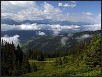
Kitzbuehel Alps green
From Schmittenhoehe you descend by the promenade path to Kettingtoerl, from where you don't really need to descend further to Pinzgauer Huette, but can continue by the Pinzgauer Spaziergang below the Kettingkopf on Kesselscharte. There you will be able to admire some nice ponds in addition to the views on both sides. From this saddle the trail crosses horizontally below Maurerkogel to Roehrertoerl and further similarly below Gernkogel to Klammscharte. By the small wooden hut/shelter you'll probably take a short rest.
The continuation is similar - the trail crosses the slopes below Zirmkogel, actually the whole are of Hochsonnberg towards Klinglertoerl. Below it you should decide. The Pinzgauer Spaziergang crosses horizontally, but if you have some additional energy and time it's worthwile to ascend the saddle of Klinglertoerl and the steep Hochkogel above it. This is the highest point of the tour, 2249 m. Towards the west you continue to the sharp Hochsaalbachkogel. Its ridge is on a few places exposed and protected with steel cables, so this is no more an easy walk. When you pass it, you cross also Medalkogel and reach the Medalscharte (signs, inscriptions). If you don't intend to prolongue over the summits, you need to descend a few meters towards the south (no marks here) until you reach again the comfortable Pinzgauer Spaziergang.
It crosses horizontally the next mountain group, you pass big electricity towers and on the other side continue to the broad Sommertor. Here you similarly need to decide whether to continue over the summits or by the horizontal trail. The latter goes on the altitude of some 2000 m, encircled Manlitzkogel and its southern fore-summit Pihappenkogel and then continues long way towards the NW until it reaches Murnauer Scharte. There you keep left, first do some more crossing, and then descend steeply over the grassy and partly rocky terrain to Buerglhuette.
You'll certainly be glad to see your bikes waiting, so you can immediately continue. You have quite some more biking to Zell am See.