-
 16971 Hits
-
 76.65% Score
-
 7 Votes
|
|
Route |
|---|---|
|
|
43.49860°N / 122.19299°W |
|
|
hike/scramble/snow climb |
|
|
Most of a day |
|
|
class two / easy third class. |
|
|
Approach
Approaching north or south along I-5 corridor take exit 188 willamette hwy 58 toward central oregon/klamath falls. Drive approximatly 36 miles to the city of oakridge. Proceed through oakridge at the east edge of town you will come to an exit on the right going south for kitson springs/ hills creek resevior. Then go approximatly 0.5 tenths of a mile to a fork. Take right fork road 21/summit lake. Follow this road for twenty nine miles. Along the way you will pass Hillscreek resevior and a series of campgrounds all along the middle fork of the willamette river. When you reach indigo springs campground you then take the left turn on to road 2149. Then drive this road for approximatly five miles to road 2160 this is a major fork you will make a right. Drive 0.5 to trailhead on left side of road.Route Description


The pioneer gulch trail begins in an old growth fir forest and travels due east and is quite steep all the way to the junction at 1.5 miles. The junction has a sign posted corrigan lake pointing left are roughly north and rockpile lake right or south bound (*note the lakes trail runs north to south on the west side of the wilderness. ) Then from the junction or sooner depending on snow conditions you will leave the trail. From the trail junction take a compass bearing 40 degrees northeast. it is possible from the junction to put the bearing right on the south summit which is your initial objective. with a G.P.S record your waypoint here. The route is a bushwack for about three quarters of a mile through an undulating forest of mixed fir and hemlock to find the southwest ridge.
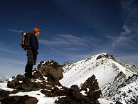
The ridge is not visible until your on it. On your map it is the prominent ridge that runs southwest from the false summit. The route starts to climb steeply and at about 7,400. the trees start thinning out . Once on the ridge, to the climbers left or west should be the corrigan lake ridge/west ridge forming the opposite wall of a deep bowl at the head of pioneer gulch. Higher up this bowl forms the southwest face of diamond peak. To the right the ridge tapers into much shallower bowl and its opposite wall is a spur of the south ridge. The route in summertime becomes a boulder hopping scramble with a few gendarmes along the way to the false summit at 8,421 ft
In snow conditions the trail can be a bushwack from the trailhead. put your compass on a true east bearing. The way is steep for the first mile and a half until you reach a forested plateau or bench. At this point the false summit should be at 35 to 40 degrees of true north. the ridge you access will be to climbers left. Wait to ascend when it becomes a bit more visible or prominant. It then is upward and undulating through along the lower ridge. The route is even steeper with snow as it leaves the forest ascending the upper ridge. Then From here to the false summit it will be snow fields with intermittent gendarmes and boulder islands. (Be careful here for motes along the boulders easy to break a leg).
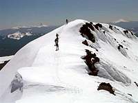
The route from the false summit follows a narrow ridge with gendarmes north to the summit pyramid. In summer It's best to stay right of the gendarmes though I believe you could negotiate them differently if conditions warrant it. In spring snow conditions the cornices can be quite large. it is best to stay on top or to the wind ward side. then climb on up the summit pyramid. On the descent the main concern is once below the false summit stay with the ridge you ascended all the way back to the forest. The natural fall line is to the south and it can be easy to get off track. Once at tree line your back to map compass/G.P.S. Or tracking down your surveyors tape and removing it as you go.
Essential Gear

The traverse from the false to the true summit is a 3rd class scramble. Early season conditions usually require snow shoes or skis. up higher on the mountain ice axe and crampons can become nessessary . The use of wands for navigation can come in handy As well as rope on the traverse when conditions are poor.
Diamond peak is an excellent climb to teach the basics to begginers and is used as such by the outdoor club that I am associated with called the Obsidians
Miscellaneous Info