
-
 3312 Hits
-
 79.6% Score
-
 11 Votes
|
|
Mountain/Rock |
|---|---|
|
|
46.75014°N / 10.37023°E |
|
|
Download GPX » View Route on Map |
|
|
Hiking |
|
|
Summer, Fall |
|
|
9521 ft / 2902 m |
|
|
Overview
 Weißkugel seen from Lajet da Lischana, Piz 2902 to the very left Weißkugel seen from Lajet da Lischana, Piz 2902 to the very left |
S-charl is an old miners settlement in the midst of the Sesvenna Group a.k.a. Engadin Dolomites. Thanks to the narrow road which leads there from Scuol it is the best trailhead for many routes in the group. However, since much of the surrounding area is covered by the Swiss National Park and thus can only be explored on the assigned hiking trails most visitors turn either north or west into unrestricted terrain. In particular, Val Sesvenna in the east of the hamlet, which separates the Madlein and Sesvenna Subgroups is of interest as it heads towards Piz Sesvenna the highest mountain of the group.
Near Alp Sesvenna a path turns off northwards heading towards the gap between Piz d'Immez and Piz Cotschen. The route is very popular even though the ground is very brittle and the route rather serious in consequence. It uses the rib between two dried out creek beds which heads for the gap in a direct very steep line. The popularity of the route is due to the many glacier lakes which await you beyond the gap: Lajet da Lischana, Lais d'Immez and Lais da Rims. A more or less trailless path leads to Piz Lischana and even more pathless ascents lead to Piz d'Immez and Piz Cotschen. Among all those summits there is a long stretched unnamed back of 2902m elevation - a wonderful lookout across the mountain groups of the area.
 Piz Cortschen and Piz de l'Aua above Lajet da Lischana Piz Cortschen and Piz de l'Aua above Lajet da Lischana | ||
 Muttler Muttler |  Weißkugel Weißkugel |  Bernina Group Bernina Group |
 Hintereisspitzen Hintereisspitzen |  Weißseespitze Weißseespitze |  Piz d'Immez Piz d'Immez |
Piz 2902, as I want to call it, rises directly above the Lais d'Immez, which separate it from the mountain of the same name. It is an easy summit if you want to go beyond the lakes but shy away from the pathless ascents of the slightly (100m) higher mountains around. From Lajet da Lischana yon need to steeply climb some 50m until you reach the top of the whaleback. A few ups and downs lead you to the marked summit at the eastern end. Drops to Lais d'Immez and the valleys in the east and north amount to some 150m.
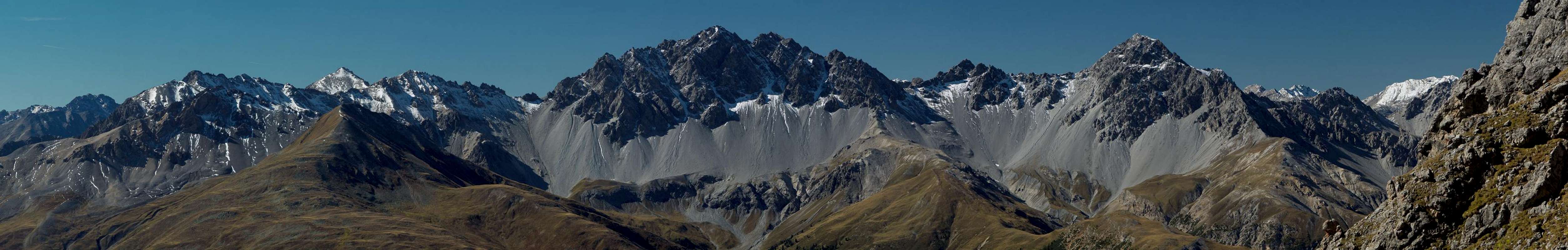
Nearby views include the mountains of the Sesvenna Group while the mid-range views go out to the Ötztal Alps, the Samnaun Group, the Livigno Alps as well as the Ortler and Bernina Groups. And in the distance you are able to see as far as the Pale di San Martino in the southern Dolomites (130km).
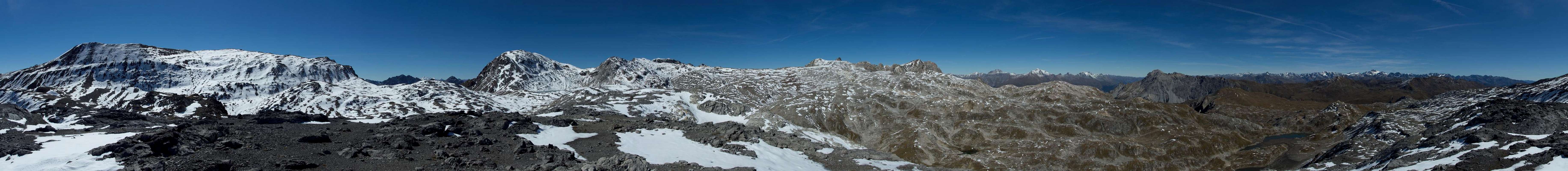
360° Summit Panorama
  |
Getting There
 |
S-Charl
Take B27 through Inn Valley from the Austrian / Italian / Swiss border near Martina or from Switzerland across Flüelapass. East of Scuol a road turns off south, passing the town and crossing the Inn River. It follows the Clemgia River to the summer village of S-Charl. There are big parking lots around the village, which, however, have to be paid (5 CHF).
Sur En
Also take B27 until you reach Ramosch. Drive to the hamlet Sur En on the Inn River where the hike through Uina Gorge starts.
Schlinig
Take the Reschenpass road SS 40 until you reach the village Burgeis / Burgusio. Drive through the valley and follow the signs for Watles and Schlinig. The road passes Marienberg Monastery a winds up the slopes of Watles until it reaches an intersection. Straight on is the road to Schlinig, where you need to park your car outside the village on a toll free parking lot.
Routes
 |
There are three routes to Piz 2902 but honestly only the first one is reasonable for this destination.
Val Sesvenna
From S-charl follow Val Sesvenna until you reach Alp Sesvenna. Pass the farm building and some 300m afterwards turn left (north, sign: Lais da Rims). An extremely steep and brittle ridge leads you to a saddle beside Lajet da Lischana. Pass the lake on its eastern shore and head up towards Piz 2902, which towers above Lai d'Immez. 1200m elevation gain.
Uina Gorge and Lais da Rims
Trailhead is Sur En, a hamlet on the Inn River, below Ramosch. Follow Val Uina until you get to the spectacular Uina Gorge. Hike through until you reach Alp Sursass. Turn right (west, sign: Lais da Rims) and head steeply up to the lakes. Pass them until you get to Lajet da Lischana. Turn east onto the long back of Piz 2902. 1800m elevation gain
Schlinigsattel
From Schlinig in Italy (South Tyrol) hike out the valley until you get to its end and head steeply upward to Schlinigsattel. Pass Sesvenna Hut and head across a fenn towards Alp Sursass. Turn left (west, sign: Lais da Rims) and head steeply up to the lakes. Pass them until you get to Lajet da Lischana. Turn east onto the long back of Piz 2902. 1400m elevation gain.
Red Tape
 Lajet da Lischana
There is no red tape in this section of the Sesvenna Group. However, you get close to the international border between Italy and Switzerland (Uina Gorge Route) so you might want to bring your ID.
The parking lot at S-charl requires a fee of 5 CHF.
Accommodation
Accommodation in the greater area:Italy
Switzerland
Weather Conditions
Maps & Books
Maps
- Digital Maps
- www.swissgeo.ch
- http://www.pcn.minambiente.it/GN/index.php?lan=en
- Vinschgau / Val Venosta
Kompass GPS Map GPS 4052
ISBN: 3-85491-659-0
- www.swissgeo.ch
- Regular Maps
- Vinschgau / Val Venosta
Kompass Map WK 52
1:50.000
ISBN: 3-85491-058-4
- Unterengadin-Nationalpark
Kompass Map WK 98
1:50.000
ISBN: 3-85491-331-1
> - Obervinschgau / Alta Val Venosta
Kompass Map WK 041
1:25.000
ISBN: 3-85491-580-2
- Schweizer Landeskarten, available at German Alpine Club
- SLK 259 S Ofenpass, 1:50000, Art.Nr.: 147259
- SLK 1219 S-charl, 1:25000, Art.Nr.: 141219
- SLK 259 S Ofenpass, 1:50000, Art.Nr.: 147259
- Vinschgau / Val Venosta
Books
- Vinschgau-Ortlergruppe
Kompass Guidebook WF950
Kompass Verlag
ISBN: 3-85491-404-0
- Unterengadin
Rudolf Weiss / Siegrun Weiss
Rother Verlag
ISBN: 3-7633-4043-2
- Vinschgau
Henriette Klier
Rother Verlag
ISBN: 3-7633-4205-2