
|
|
Mountain/Rock |
|---|---|
|
|
37.17125°N / 118.5855°W |
|
|
Inyo |
|
|
Hiking, Scrambling |
|
|
Summer, Fall |
|
|
11938 ft / 3639 m |
|
|
Overview
Point 11938 is located just within the John Muir Wilderness Area boundary, and rises 2160 feet directly west above South Lake. While lower than many of its neighbors, the summit views are tremendous and encompass a wide range of peaks in the John Muir Wilderness and the High Sierra.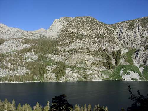
Peak 11938 directly above South Lake
It is easily accessible via a short approach route from South Lake Road, and requires class 2/easy class 3 scrambling to reach the summit. It shares a saddle with the Thompson Ridge, rising only about 250 ft above the highest crossing point. So, technically it isn’t its own peak. However, given that it stands out dramatically above South Lake, and stands out from every vantage point around it, it is a worthwhile destination.
Due to its short approach, there are options for other hikes and climbs nearby, particularly peaks along the nearby Thompson Ridge. The best time to hike in this area is July through early October. The road to South Lake is closed in winter, and snow is abundant most of the year.
Getting There
There are two trailheads for this peak. The shortest and most direct is the Tyee Lakes trailhead off of South Lake Road. Take route 168 from Bishop at West Line Street, and continue for about 14 miles to the turn off to South Lake Road. Get on South Lake Road and drive about 4½ miles up to a parking area on the right side of the road. It is marked as the Tyee Lakes Trailhead. The elevation here is about 9,055’.The Tyee Lakes trail can also be accessed from Lake Sabrina, via a longer route. To get to Lake Sabrina, continue past the South Lake Road turn off and follow for another 4½ miles to the lake. The trail starts on the north end of the lake at a little over 9,100’.
Route Information
Tyee Lakes Trailhead off South Lake RoadFrom the Tyee Lakes Trailhead off South Lake Road follow the trail as it switchbacks steeply up through the forest. After about 1½ miles you pass the first lake on the left. You pass a second lake on your left, and then a third lake on your right.
There are two options here.
The first is to cut up to the north ridge. Leave the lake and head left (south). Find the most suitable path up the peak, and climb about 400’ to the summit ridge. This requires class 2/easy class 3 scrambling, which is steep and challenging, but not too difficult because only 400’ has to be attained. Once at the summit ridge, the final stretch to the summit obvious. It requires an easy 250 foot scramble, then an easy walk up the remaining 188' to the summit.
The second option, which works better for the descent, is to continue on the trail to a fourth lake, on your left. You will see a lowpoint on the ridge directly ahead of you (directly west) above another lake. Leave the trail and climb up the ridge, which is class 2 scrambling. Once at the lowpoint on the ridge, head to the left (south). Scramble up a couple hundred feet, and the terrain levels out. It is now an easy half mile walk up to the summit.
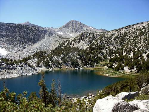
The low point on the ridge. North Thompson Ridge Summit (12,744') in the distance.
The total round trip hiking distance from the Tyee Lakes Trailhead off South Lake Road is about 7 ½ miles if taking the first option up and second option down. If using the 2nd option for ascent and descent it is about 8 miles round trip. One way elevation gain is about 2900’.
Lake Sabrina
From Lake Sabrina take the main trail around the east side of the lake. Near the south end of the lake, the trail splits. The trail heads east towards Lake George Camp and the Tyee Lakes. Take this trail as it steeply climbs to a plateau referred to as Table Mountain. Once near the plateau of the trail, you can see Point 11938 to the south. Head up to the summit of Table Mountain 11,651' and down to the same saddle described above, and follow to the summit.
This route is about 10 miles round trip, with a one way elevation gain of about 3,050’.
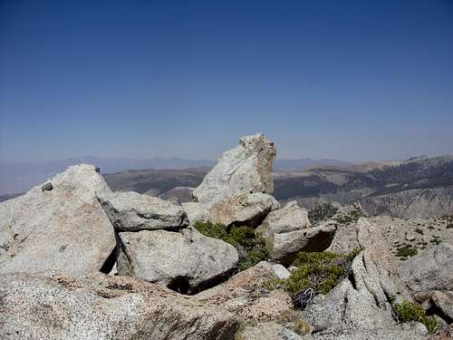
The summit rock
There is a shorter way up from Lake Sabrina, but with less distance on the trail, and more off-trail. Before the trail heads up Table Mountain at George Lake, leave the trail and head directly up the canyon to a saddle between the Thompson Ridge and Point 11938. The saddle is at a little over 11,650'. From here it is an easy walk up to Point 11938. This route is about 8 1/2 to 9 miles depending on the route taken, with a gain of about 2900'. About 40% of it is off trail, compared with only about 20% off trail for the longer (but more scenic) route from Lake Sabrina.