
|
|
Route |
|---|---|
|
|
47.50290°N / 120.8013°W |
|
|
Hike with cl 2/3 scramble |
|
|
Less than two hours |
|
|
Walk up |
|
|
Approach
Most of the approach is listed on the "getting there" portion of the front page.
TRAILS:
Snow Lake Trail - The popular route for many is the Snow Creek Trail, taking off at the Snow Creek TH, just off of the Icicle Creek road. Elevation begins at 1300 feet and after a little drop down to a bridge across the Icicle River, it begins a series of switchbacks that lead upward and onward, never relenting until you come into the middle Enchantment Lake area, a distance of close to ten miles. Camping is possible at Nada or Snow Lakes if you get a late start. The elevation gain is close to 5400 feet or more, depending upon where you camp. A good area to camp at is just below Inspiration Lake's outlet (sprite lakelet) or bekyond Prusik Pass near Shield Lake at the southern end, many campsites in the trees (along with nasty mosquito that are a real pain so take bug juice)
Stats: 11.5 miles to Cannon Mtn's summit and 7300 + feet (some loss going down Prusik Pass towards Shield Lake which will need to regained on return - add 800 feet more) Highly recommended to plan on at least one night of camping if you go this way. An exit route using Toketie Lake is possible but not recommended.
Aasgard Route (via Colchuck Lake) - This is becoming a very popular way as the distance is shorter. From the Stuart Lake TH, take the Colchuck Lake Trail as it splits off and go up the Colchuck Lake trail to Colchuck Lake, a nice place to camp (permit required) . It is 4 1/2 miles to the Lake and another 2 1/2 miles to Perfection Lake. The hike up to Aasgard Pass is a work out and you gain 2200 feet in about a mile. Then follow the cairns as the trail works its way through the moonlike terrain of the Upper enchantments until you find your path down to Perfection Lake (camping spots available here). Dropping down from Perfection Lake (Talisman Lake on some of the older maps), find the trail to Prusik Pass at the north end of Inspiration Lake. The elevation gain from the TH to Colchuck Lake is 2000 feet (TH elevation 3300 feet) and then you gain 2200 feet in less than a mile to the top of Aasgard pass (7800 feet) before you enter the upper Enchantments and travel across this area to access.
Stat's 8 miles to Cannon's summit plus 5300 feet not including the gain and loss incurred in dropping over Prusik towards Shield Lake.
Whether you take the Snow Lake Trail or the Colchuck / Aasgard Pass route, the key is to get to Prusik Pass, a 400 climb up from Inspiration Lk (Rune Lake under older naming of the Starks).
 |  |  |  |
Route Description

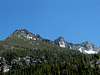
From Prusik Pass, drop down towards Shield Lake rather than go direct from the pass. See this TOPO map for about the right area and then start up and you'll find yourself near the little ponds shown on the the map provided. From the ponds, aim westerly toward a small saddle and then head northerly to the peak. The peak itself is a short scramble with room for one. A magnificient viewpoint. Be sure to go a little bit more to the north and peer down at lone Coney Lake.
PRUSIK PASS ROUTE NOTES:
Various routes to Cannon Mountain exist from near Prusik Pass most of which go through the Druid Plateau. Gain the Druid Plateau at an easy gap in Elf Ridge just to the NE of the summit. From here it 's an easy sand and boulder walk to the summit block. The high point is a large, slightly tilted rock with a small flat spot at the top room enough for one person to sit. The summit of Cannon offers up an excellent and somewhat unique view of Stuart Lake and Mount Stuart.
The north side of Prusik pass has a good use trail when the snow is gone but may require an ice axe in late spring due to remaining snow. I'd carry an ice axe and crampons in early season. I've tried to go direct from the pass but found it takes longer than making the drop down towards Shield Lake and angling cross country from there. The Druid Plateau is one of the best features to enjoy in the Enchantment region but much better in good weather.
Essential Gear
Normally, no special gear is needed, particularly during the summer and fall. Avoid during thunderstorms. Winter climbs would of course require winter gear which would include snowshoes, ice axe, crampons and warm clothing.
Miscellaneous Info
If you have information about this route that doesn't pertain to any of the other sections, please add it here.
goleary - Jun 21, 2016 12:45 am - Hasn't voted
Route description misleadingRoute description says head 'westerly' from the ponds on the map to the saddle point and then north to the summit. This is precisely what we did, heading west from the ponds to the most obvious saddle point, but we found ourselves on a ridge that would've required low 5th class climbing to traverse. After backtracking we headed to what would've been NW from the ponds to gain the Druid plateau and then route was obvious to the summit.