


-
 2737 Hits
-
 79.04% Score
-
 10 Votes
|
|
Route |
|---|---|
|
|
45.60253°N / 7.17324°E |
|
|
Hiking, Mountaineering |
|
|
Summer, Fall |
|
|
A long day |
|
|
EE/F/F+ (Expert Mountaineers / Easy) |
|
|
Note
|
La montagna chiama i suoi figli, ed essi rispondono fedelmente al suo appello… Osvaldo Cardellina, Diario alpinistico, 1964-65 Page texts: @ OsvaldoCardellina "Osva", passed away on May 2, 2022. Page owners: Christian Cardellina e Osvaldo Cardellina. Any updates from September 12, 2022: Antonio Giani, page administrator, friend and climbing companion. Testi della pagina: @ OsvaldoCardellina "Osva", scomparso il 2 maggio 2022. Proprietari pagina: Christian Cardellina e Osvaldo Cardellina. Eventuali aggiornamenti dal 12 settembre 2022: Antonio Giani, amministratore della pagina, amico e compagno di salite. |
Royal Overview 1861
Bioula, "patois" Biula, named this by Birch present in Valsavara, while Roletta comes by "Pinus cembra" then Roley Aroletta.
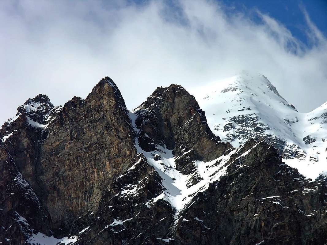
Other two names are shared equally between the valleys with Rhêmes Nôtre Dame for the two Towers of Nôtre Dame and forthe following Clocher de Djuan, sister to Punta Bianca, lying towards the Valsavarenche on Djuan Montagne, so dear to the Notary Lorenzo Chabod. First climbers, faithful to the local place names, however, have preferred to transform the primitive Clocher Lorenzo Chabod in that of Djuan both because it dominates the homonymous alp, both symmetrical assonance and for place names with the two Tours de Nôtre Dame (Northern ans Southern). Remains the Punta Bianca (White), being rocky, this color highlights little, if not a speck residual snowfield on the East Edge of the dominant "Parei Neire" or Black Wall. Or in case of snowfall that usually cloaked its North-northeast Walls, Northwest and Southwest. But it is something quite common knowledge that with the snow all become white Summit not distinguished from each other mountain.
Amongst the five Peaks of these the really famous one is the Bioula much that the Italy's King Vittorio Emanuele II° had built a mule track from the Real Camping of "Pavillon de Chasse" near Orveille reach the Top since 1861, year of the Italy's unification. Today, unfortunately, is in advanced stage of progressive decay especially at the top just before you reach the Cima, where with ear well alert and sniffing the air still feel the pawing and the smell of real mules that carry riding their "King Toio", escorted by Royal Guards. This it marks the beginning of the Mountaineering up to then to the "classical period" of the Twenties Thirties, where they were "ransacked" even minor peaks.
Aged postcard taking one back to a distant time, as well as to the ridge crossings of this type, or simply climb along and up the wild Side of the South East ...
![]()
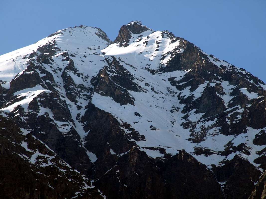
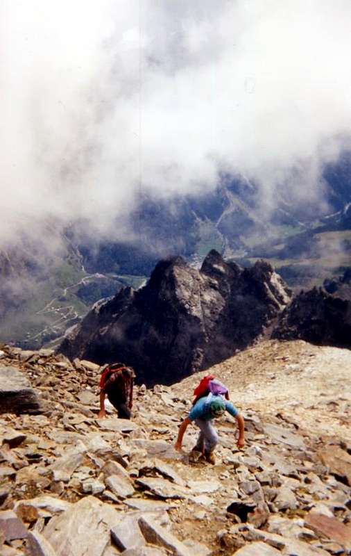
Terminal part of Standard Route just above to the Northwest of Fourquin de Bioula, by Antonio 2006
Di queste Cime l'unica veramente famosa é la Bioula tanto che il Re Vittorio Emanule II° aveva fatto costruire una mulattiera che dal Campeggio reale de "Orveille" raggiunge la Sommità sin dal 1861, anno dell'unificazione d'Italia. Oggi purtroppo risulta in avanzato grado di progressivo disfacimento soprattutto nella parte superiore appena prima di raggiungerne la Cima, ove con orecchio ben attento ed annusando l'aria sentite ancor lo scalpitio e l'odor dei muli reali portanti in groppa il lor "Re Toio", scortato da più Guardie Regali. Ciò segna l'inizio dell'Alpinismo sino a poi raggiungerne il "periodo classico" degli Anni Venti e Trenta, ove venivan "rovistate" anche le Cime cosiddette minori.
Cartolina invecchiata adducente a tempo lontano, così come le traversate in cresta di questo tipo, oppure la semplice salita lungo il selvaggio Versante Sudest ...
![]()
Normal Via from Degioz-Orvieille-Fourquin de Bioula, by livioz 2002
![]()
Just to the right or North by Fourquin de Bioula, by Osw 2016
Other two names are shared equally between the valleys with Rhêmes Nôtre Dame for the two Towers of Nôtre Dame and forthe following Clocher de Djuan, sister to Punta Bianca, lying towards the Valsavarenche on Djuan Montagne, so dear to the Notary Lorenzo Chabod. First climbers, faithful to the local place names, however, have preferred to transform the primitive Clocher Lorenzo Chabod in that of Djuan both because it dominates the homonymous alp, both symmetrical assonance and for place names with the two Tours de Nôtre Dame (Northern ans Southern). Remains the Punta Bianca (White), being rocky, this color highlights little, if not a speck residual snowfield on the East Edge of the dominant "Parei Neire" or Black Wall. Or in case of snowfall that usually cloaked its North-northeast Walls, Northwest and Southwest. But it is something quite common knowledge that with the snow all become white Summit not distinguished from each other mountain.
Amongst the five Peaks of these the really famous one is the Bioula much that the Italy's King Vittorio Emanuele II° had built a mule track from the Real Camping of "Pavillon de Chasse" near Orveille reach the Top since 1861, year of the Italy's unification. Today, unfortunately, is in advanced stage of progressive decay especially at the top just before you reach the Cima, where with ear well alert and sniffing the air still feel the pawing and the smell of real mules that carry riding their "King Toio", escorted by Royal Guards. This it marks the beginning of the Mountaineering up to then to the "classical period" of the Twenties Thirties, where they were "ransacked" even minor peaks.
Aged postcard taking one back to a distant time, as well as to the ridge crossings of this type, or simply climb along and up the wild Side of the South East ...
La Bioula, in "patois" Biula, dal nome della betulla presente sulla Valsavarenche (vedi Forquin de), mentre Roletta deriva dal "pinus cembra" o Aroletta e Roley.
Gli altri due toponimi vengono spartiti equamente tra le due vallate con Nôtre Dame per la Torre e Djuan per il Clocher, gemello alla Punta Bianca, riverso verso la Savara sulla Montagne de Djuan, tanto cara al Notaio Lorenzo Chabod. I primi salitori, fedeli alla toponomastica locale, han però preferito tramutar il primigenio nome di Clocher Lorenzo Chabod in quello di Djuan sia perché domina l'omonima alpe, sia per un'assonanza simmetrica e toponomastica con le due Tours de Nôtre Dame (Settentrionale e Meridionale). Rimane la Punta Bianca che, essendo rocciosa, di questo colore n'evidenzia poco, se non una macchiolina residuo di nevaio sulla Cresta Est dominante la "Parei Neire" o Parete Nera. Od in caso di nevicata in genere ammantante le sue Pareti Nord-nordest, Nordovest e Sudovest. Cosa ben risaputa che con neve tutte le Sommità divengon bianche non distinguendosi l'una dall'altra.Di queste Cime l'unica veramente famosa é la Bioula tanto che il Re Vittorio Emanule II° aveva fatto costruire una mulattiera che dal Campeggio reale de "Orveille" raggiunge la Sommità sin dal 1861, anno dell'unificazione d'Italia. Oggi purtroppo risulta in avanzato grado di progressivo disfacimento soprattutto nella parte superiore appena prima di raggiungerne la Cima, ove con orecchio ben attento ed annusando l'aria sentite ancor lo scalpitio e l'odor dei muli reali portanti in groppa il lor "Re Toio", scortato da più Guardie Regali. Ciò segna l'inizio dell'Alpinismo sino a poi raggiungerne il "periodo classico" degli Anni Venti e Trenta, ove venivan "rovistate" anche le Cime cosiddette minori.
Cartolina invecchiata adducente a tempo lontano, così come le traversate in cresta di questo tipo, oppure la semplice salita lungo il selvaggio Versante Sudest ...
First Ascents
- First on the summit: Unknown.
- In winter: Unknown.
- South-southwest Ridge (to Tours de Nôtre Dame): Michele Baratono and Federico Chabod; September 01th, 1924, in descent from Punta Bioula.
- Southeast Slope (Normal Route): Unknown.
- West Wall: Leonardo Cossard and Remo Chabod; June 1938.
- Northwest Crest and West Face: Pier Francesco Quaini, lone; August 31th, 1914, in ascent from Western Bioula Basin.
- Northern Ridge: Lorenzo Rossi di Montelera with Guide Lindo Lucianaz; August 06th, 1976, in ascent from Rhêmes Creton and through Nequedé Pass.
- East-southeast Ridge: Osvaldo Cardellina, lone; September 24th, 1988, in ascent from Eaux Rousses and through Quotas 2.795, 3.125 meters.
Getting There
BY CAR:
![]()
Degioz Village from Punta Bioula, by Osw 1994
BY PLANE:
![]()
Orvieille just below the Fourquin de Bioula, by andrea.it 2012
- From TORINO, MILANO, etc: Motorway A5. Exit at IVREA or Quincinetto (PIEDMONT) also Pont Saint Martin, Verrès, Chatillon, AOSTA East (Nus) and West (Aymavilles) Municipalities (AOSTA Valley).
- From IVREA Town to Aymavilles, Villeneuve, Introd Municipalities.

- From Aymavilles to Villeneuve and by this to Valsavarenche Valley or directly by Villeneuve.
- From Aymavilles (646m) towards Villeneuve (670m) with Regional Road in South of Baltea and from Villeneuve to Introd (880m) at the beginning of entrance in Valsavarenche Valley and Dégioz Chief town (1.541m). It is not necessary to take Motorway A5: you can drive on SS.26, in the direction of AOSTA - IVREA - TURIN.
BY PLANE:
- Aeroporto "Corrado Gex" Saint Christophe (Aosta).
Approaches & Route Description
Ancient ascent dedicated to mountaineers lovers of old mountains and actually enough unusual itineraries, at least as regards the upper parts over the saddle.
A) - From Degioz-Valsavarenche: by Degioz Chief town (1.541m) reach to the Southwest through the trail n° 8/8B the wide "Orvieille Pavillon Royal de Chasse" (2.168m); from this, flexing with a diagonal route towards the Northwest with the large and evident mule track n° 8A easily reach, after bypassing a large saddle 2.905 meters, just to the West respect of the characteristic and trible Forquin or Fourquin de Bioula entering a small secondary vallon, the Summit of Bioula (EE/F; 4h'00/4h'30 Degioz).
B) - From Eaux Rousse always in Valsavarenche: from the Hamlet of Eaux Rousses (1.686m), a short drive away from Degioz going from little Villages of Bien and Maisonnasse (1.686m, 1.652m), leave the left (East) the trail towards Col Lauson taking instead the opposite side to n° 2/8C dating back to the Northwest through "le Grand Bois" to Alpe Rondzegou (1.974m). Continuing in the same direction you first arrive at the junction immediately above the Carré Alps, Ruyaz and Cleyettaz (2.026m, 1.959m, 1.900m) and immediately after "Pavillon Royal de Chasse" Orvieille whence the previous route (EE/F; 1h'15/1h'30 Eaux Rousse; 4h'30/5h'0 alltogheter until the Summit).
C) - Direct Variant by Creton of Valsavarenche: you can go directly to Orvieille starting from the small village of Creton with the path n° 7/8A reaching first toward Northwest Toulaplana (1.813m) and then in the Southwest the Pastures of Cleyvettaz, Ruyaz and Carré (1.900m, 1.959m, 2.026m; EE/F; a good quarter of an hour earlier).
![]()
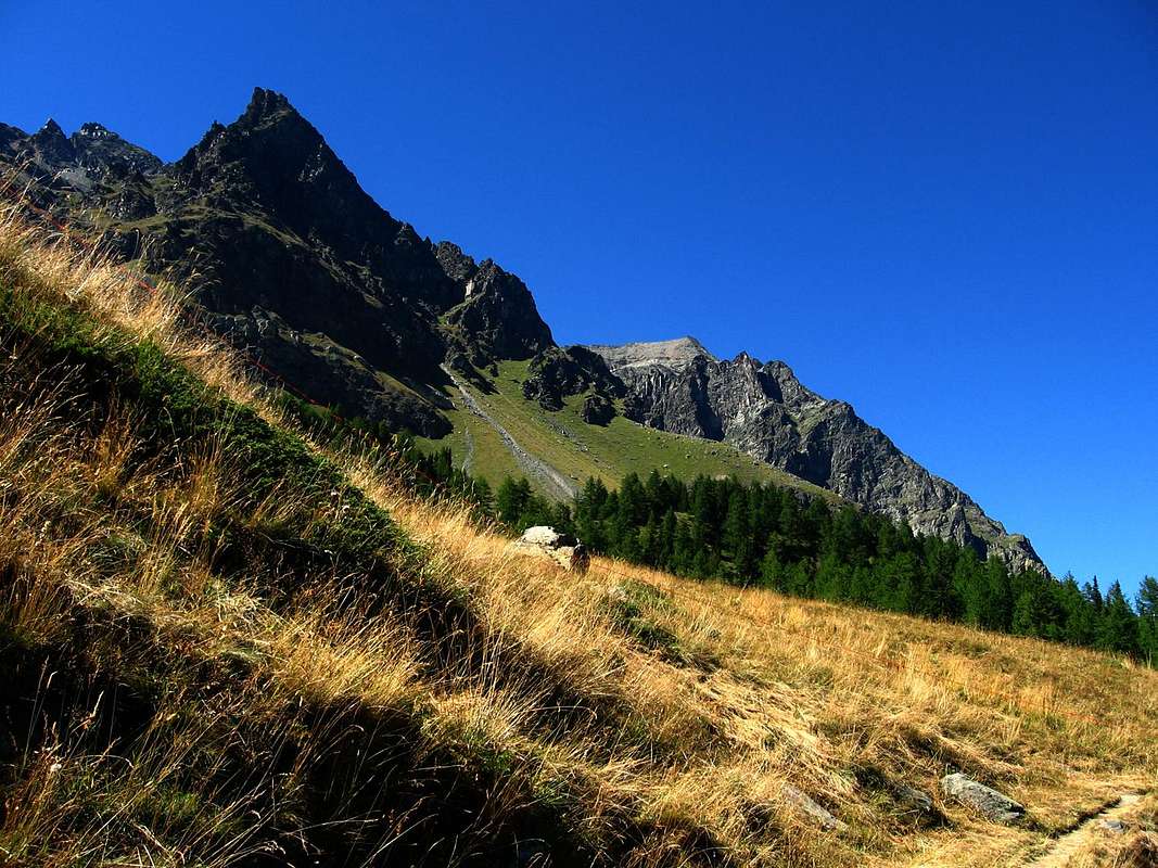
Just above the triple Fourquin de Bioula, by Osw 1994
A) - From Degioz-Valsavarenche: by Degioz Chief town (1.541m) reach to the Southwest through the trail n° 8/8B the wide "Orvieille Pavillon Royal de Chasse" (2.168m); from this, flexing with a diagonal route towards the Northwest with the large and evident mule track n° 8A easily reach, after bypassing a large saddle 2.905 meters, just to the West respect of the characteristic and trible Forquin or Fourquin de Bioula entering a small secondary vallon, the Summit of Bioula (EE/F; 4h'00/4h'30 Degioz).
B) - From Eaux Rousse always in Valsavarenche: from the Hamlet of Eaux Rousses (1.686m), a short drive away from Degioz going from little Villages of Bien and Maisonnasse (1.686m, 1.652m), leave the left (East) the trail towards Col Lauson taking instead the opposite side to n° 2/8C dating back to the Northwest through "le Grand Bois" to Alpe Rondzegou (1.974m). Continuing in the same direction you first arrive at the junction immediately above the Carré Alps, Ruyaz and Cleyettaz (2.026m, 1.959m, 1.900m) and immediately after "Pavillon Royal de Chasse" Orvieille whence the previous route (EE/F; 1h'15/1h'30 Eaux Rousse; 4h'30/5h'0 alltogheter until the Summit).
C) - Direct Variant by Creton of Valsavarenche: you can go directly to Orvieille starting from the small village of Creton with the path n° 7/8A reaching first toward Northwest Toulaplana (1.813m) and then in the Southwest the Pastures of Cleyvettaz, Ruyaz and Carré (1.900m, 1.959m, 2.026m; EE/F; a good quarter of an hour earlier).
Ascensione antica, per alpinisti amanti di vecchie montagne e d'itinerari abbastanza attualmente inusuali per quanto concerne i tratti superiori oltre la sella.
A) - Dalla Valsavarenche: dal Comune di Degioz (1.541 m) raggiungere verso Sudovest tramite il sentiero n° 8/8B il "Pavillon Royal de Chasse" (2.168 m) di Orvieille; da questo svoltando a Nordovest con la mulattiera n° 8A arrivare facilmente, dopo aver oltrepassato una larga sella 2.905 metri, tosto ad Ovest della Cima Occidentale del caratteristico nonché triplice Forquin o Fourquin de Bioula, entrando in un valloncello secondario, all'aerea Vetta della Punta Bioula (EE/F; 4h'00/4h'30 dal Villaggio di Degioz).
B) - Da Eaux Rousse sempre in Valsavarenche: dalla Frazione di Eaux Rousses (1.686 m), raggiungibile in breve tempo da Degioz passando nei pressi dei Villaggetti di Bien e Maisonnasse (1.686 m, 1.652 m), lasciare sulla sinistra (Est) il sentiero che attraversa il Torrent Savara verso il Col Lauson prendendo invece sul versante opposto quello n° 2/8C che risale a Nordovest attraversando "le Grand Bois" fino all'Alpe Rondzegou (1.974 m). Continuando nella stessa direzione dapprima si arriva al bivio subito soprastante le Alpi Carré e Ruyaz e Cleyettaz e subito dopo all'Orvieille donde alla precedente via (EE/F; 1h'15/1h'30 da Eaux Rousse; 4h'30/5h'0 complessivamente insino in Vetta).
C) - Variante diretta dal Creton della Valsavarenche: si può salire direttamente all'Orveille partendo dal Villaggetto di Creton con sentiero n° 7/8A che raggiunge dapprima verso Nordovest Toulaplana (1.813 m) e quindi a Sudovest gli Alpeggi di Cleyvettaz, Ruyaz e Carré (1.900 m, 1.959 m, 2.026 m; EE/F; un buon quarto d'ora in meno).
![]()
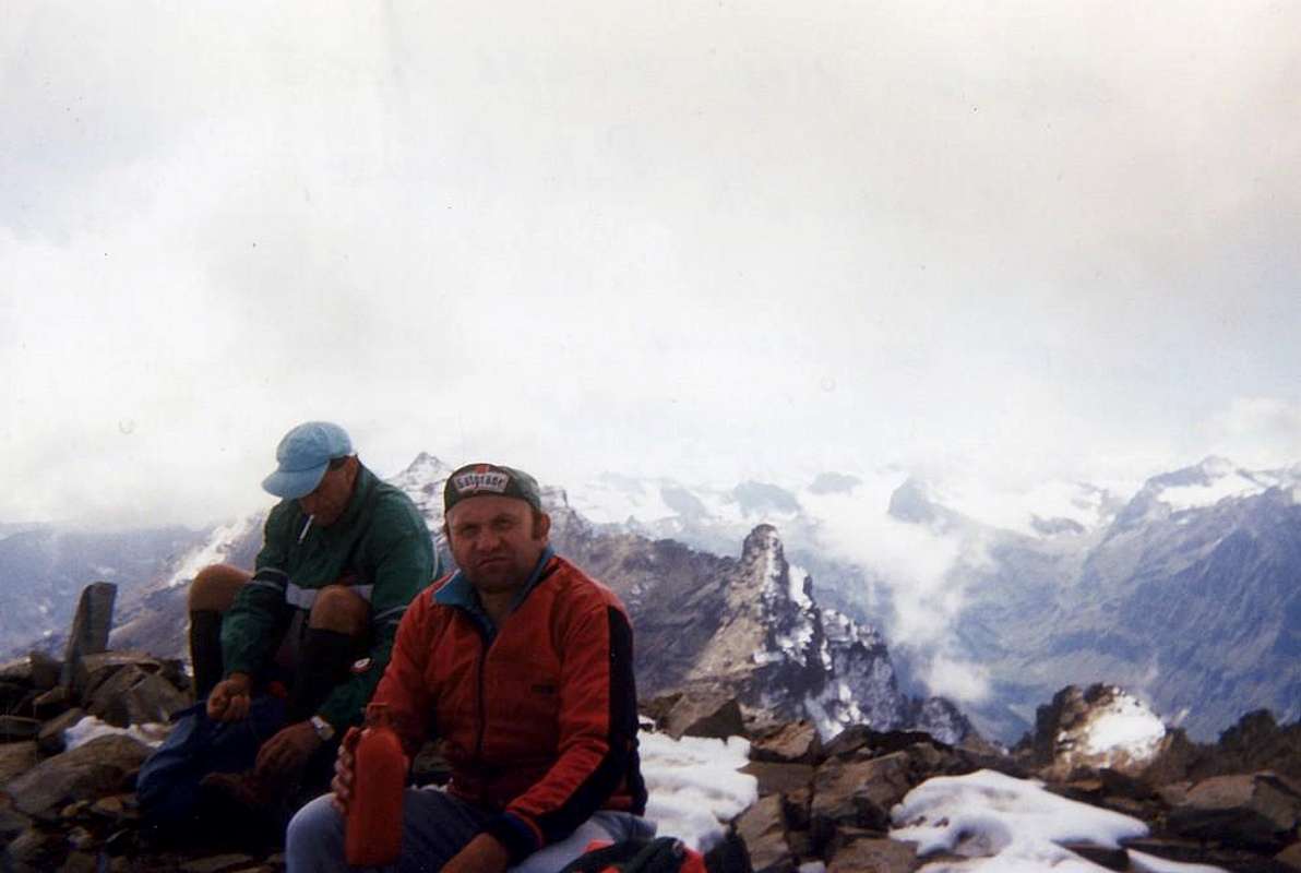
On Summit, by Giuseppe Lamazzi 1994
From F to F+.
Dal F al F+.
A) - Dalla Valsavarenche: dal Comune di Degioz (1.541 m) raggiungere verso Sudovest tramite il sentiero n° 8/8B il "Pavillon Royal de Chasse" (2.168 m) di Orvieille; da questo svoltando a Nordovest con la mulattiera n° 8A arrivare facilmente, dopo aver oltrepassato una larga sella 2.905 metri, tosto ad Ovest della Cima Occidentale del caratteristico nonché triplice Forquin o Fourquin de Bioula, entrando in un valloncello secondario, all'aerea Vetta della Punta Bioula (EE/F; 4h'00/4h'30 dal Villaggio di Degioz).
B) - Da Eaux Rousse sempre in Valsavarenche: dalla Frazione di Eaux Rousses (1.686 m), raggiungibile in breve tempo da Degioz passando nei pressi dei Villaggetti di Bien e Maisonnasse (1.686 m, 1.652 m), lasciare sulla sinistra (Est) il sentiero che attraversa il Torrent Savara verso il Col Lauson prendendo invece sul versante opposto quello n° 2/8C che risale a Nordovest attraversando "le Grand Bois" fino all'Alpe Rondzegou (1.974 m). Continuando nella stessa direzione dapprima si arriva al bivio subito soprastante le Alpi Carré e Ruyaz e Cleyettaz e subito dopo all'Orvieille donde alla precedente via (EE/F; 1h'15/1h'30 da Eaux Rousse; 4h'30/5h'0 complessivamente insino in Vetta).
C) - Variante diretta dal Creton della Valsavarenche: si può salire direttamente all'Orveille partendo dal Villaggetto di Creton con sentiero n° 7/8A che raggiunge dapprima verso Nordovest Toulaplana (1.813 m) e quindi a Sudovest gli Alpeggi di Cleyvettaz, Ruyaz e Carré (1.900 m, 1.959 m, 2.026 m; EE/F; un buon quarto d'ora in meno).
Essential Gear
DifficultiesFrom F to F+.
Dal F al F+.
 |
 |
 |
 |
 |
Equipment
For Hiking or for Mountaineering, in relation to the season.
Da Escursionismo o da Alpinismo, relativamente alla stagione.
For Hiking or for Mountaineering, in relation to the season.
Da Escursionismo o da Alpinismo, relativamente alla stagione.
Mountain Condition
- You can get meteo information at the official site of the Regione Valle d'Aosta:
- Valle d'Aosta Meteo
Webcam
- WEBCAM on Aosta Valley:
- Webcam
Important Information
- REGIONE AUTONOMA VALLE D'AOSTA the official site.
- FONDAZIONE MONTAGNA SICURA Villa Cameron, località Villard de la Palud n° 1 Courmayeur (AO) Tel: 39 0165 897602 - Fax: 39 0165 897647.
- SOCIETA' GUIDE ALPINE DEL GRAN PARADISO Comune di Valsavarenche.
- A.I.NE.VA. (Associazione Interregionale Neve e Valanghe).
Useful Numbers
- Protezione Civile Valdostana località Aeroporto n° 7/A Saint Christophe (Ao) Tel. 0165-238222.
- Bollettino Meteo (weather info) Tel. 0165-44113.
- Unità Operativa di Soccorso Sanitario (Emergency Medical Assistance). Phone: 118.New section