
|
|
Route |
|---|---|
|
|
46.59340°N / 121.841°W |
|
|
Hiking |
|
|
Spring, Summer, Fall |
|
|
Half a day |
|
|
Trail |
|
|
Overview
An interesting trail, #285, that seems to be reverting back to nature in many areas. It did not look like it had received any maintainance to us in several years. However, the trail can be followed fairly easily but attention needs to be given in a few spots, especially with snow present in the early season. The crossing of Davis Creek might not be advisable if the water level is high so waiting until the middle of June might be a wise thing to do.Round trip 8 miles
Elev. gain 2650 feet (est)
TH elevation is close to 3000 feet
Getting There
See Purcell Mtn page for this. Where to park
Route Description
Park at the wide spot just off of the forest service road. Walk up FR 63 about 150 feet to the bermed road that now serves as the trail. The old road drops downhill for about a half mile until it comes to Davis Creek, which at one time was spanned by a bridge that is no longer there. A ford of the creek is necessary and later in the season it should be an easy thing to do but earlier in the season when the water is running high, caution must be taken. You can work your way down alongside the creek on the right side by carefully using the brush belays that are available and then cross at the flat area that leads across to the trail on the other side.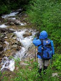
Once across, the trail heads uphill along the old roadbed and curves a bit to the left but the roadbed is getting less and less obvious that it was once a roadbed. In a short while, the old roadbed meets another berm and a trail, signed, switchbacks up to the right and into the forest. It is obvious that the trail is slowly reverting to nature (despite claims by the authors of the 100 hikes book that it is being maintained) but it is still easy to follow in most places. Seven or eight switchbacks are encountered as the trail winds its way amongst second growth forest and at about 3600 ft. elev.it enters old growth forest. After 3 miles the trail enters the first of several flower-blessed sloped meadows and zigzags up the steep slopes although the zigzags may not be obvious with snow present. The trail along the slopes are undermined by numerous tunnels in soft soil from mountain marmots or some kind of burrowing critter. I almost twisted my ankle several times as my foot plunged through some of these tunnels so be aware of this hazard.
At the ridge at 5000 ft. elevation Trail #285 joins the old Trail #284 which can no longer be accessed from Hwy. 12. Follow the wooded ridge to the right another 1/2 mile and 440 ft. up to the old lookout site at 5442 ft. elevation. We hit snow near the junction and just GPS'd our way up the slope to the old lookout site but the trail did show through in a few places.

Check out this great link
A great link describing this trail can be found HERE. Please check it out as it will give you a great idea about the trail and route I described above.Check out the pics as well.