About two months had elapsed since I paused my vagabond ways to resume a normal working life, but it had been more than twice as long since my last proper outdoors excursion. And so, with a single weekend available to me, I set off north for a brief stop in the Great Lakes on a roundabout path to Pennsylvania's Laurel Highlands.
Dry Kelleys Island quarry.
Flooded Kelleys Island quarry.
When I awakened at an Ohio interstate rest area very early Saturday, I was doing so in a rental car, as my usual companion was stubbornly giving me a host of electrical troubles at the time. This trip was actually in doubt for me, but eventually a local rental agency made the mistake of offering me unlimited miles. So now I drove this rental a short distance ahead to a gateway of the Erie Islands at the end of Marblehead Peninsula. At a Lake Erie ferry dock, I arrived more than thirty minutes prior to the morning's first departure, just early enough to squeeze into one of the last remaining spaces for a thirty-minute carriage across the waters. Kelleys Island is roughly three miles in diameter and separated from the mainland by four miles of blue-green Lake Erie shallows. This Great Lake is the shallowest of the five, particularly here among the islands in the western half, where the depths barely precluded a glimpse of the bottom from the ferry platform. Once at the island dock, I disembarked and went clockwise around the shoreline drive to the north shore’s hiking trailhead. Just adjacent to the trailhead was the impressive Glacial Grooves State Memorial. The rock formations here were naturally hidden over time by the elements of erosion, but that organic material has been cleared to display the spectacle. It is a long series of rounded channels slowly carved during the Ice Age. Glaciers and their massive weight pressed upon stray rocks and boulders to gouge these channels as the glaciers crept along. Though smoothly sculpted at first glance, the grooves had a pretty rough texture to them from the recent years of exposure. After a few minutes, I had seen all there was to see, so I walked over to the nearby North Shore Loop Trail.
Fascinating grooves carved in the rock by Ice Age glaciers.
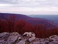
Two remnants of early settlement marked the start of the loop, a large decaying concrete structure and the hardly-recognizable carcass of an antique truck. A little farther, however, the only sights were the small, skinny forest and its saturated floor. After walking a half-mile or so through the damp understory, the trail drew near to the lakeshore and I cut through to it. All along the northern coast of the island stretches an alvar habitat of limestone bedrock and sparse soil. These limestone outcrops meet the water's edge and take the cumulative abuse of the season's waves and freeze-thaw cycles. The rock ledges are uneven and fractured, spanning the spectrum of grays from bleached to darkened. They are not especially tall. At their highest, they lifted me perhaps fifteen feet above the water level, although that was enough to give me better views of nearby Pelee and Middle Bass Islands, and even a distant glimpse of the Canadian shore on the horizon between. Here indeed, I could see entirely across Lake Erie.
Beginning of the alvar shore.
Additional glacial evidence.
Slippery ledges on Lake Erie.
I balanced my way around the ledges and protruding rocks for a little way east along the lake, and then I reversed course and did the same on the more rugged and exposed shore going west. Clumps of moss affixed themselves around the edges of several damp rocks near water level but not the tops. These rocks could still be very slimy and one in particular nearly sent me into the lake. A satisfying lunch on the highest ledge seemed like a better idea than further tempting fate on the slippery surface boulders. The lake stretching north of my picnic site appeared more blue than beside the mainland, a nearly seamless blend into the cloudless sky. Its surface was dotted with distant fishing boats in every direction. They seemed motionless from my view, only an occasional hum of an engine ever indicated otherwise. It was an especially peaceful setting, ideal for reading a while after my meal. I took a souvenir rock from the shore here as I left.
Along the North Shore Alvar Preserve at Kelleys Island State Park on Lake Erie.
Just prior to noon, I finished the short return hike back to my rental car as I aimed for the 12:30 mainland ferry departure. With the minutes I had to spare, I explored the first fraction of a mile along the interior East Quarry Trail. Rock quarrying fills a large part of the island's developed history - there was another large example directly adjacent to the Glacial Grooves site - and this pit had filled with enough water to create a large lake. I also glanced at Inscription Rock, on which is etched a largely-weathered native pictograph that is centuries old. But quickly, it was time to depart the island and return to greater Ohio. There was a lengthy afternoon of driving ahead of me.
Laurel Highlands, Pennsylvania
My Laurel Highlands campsite.
Twenty miles, one evergreen.
Once I crossed back over Sandusky Bay, I traveled a general southeast course from the islands toward the Laurel Highlands, nearly three hundred miles away in Pennsylvania. Inside the Keystone State, low mountainous terrain gradually took over and small towns lurked around nearly every bend. Much of the roads were not conducive to efficient travel. They were often undulating two-lane roads with little to no passing zones. Even the interstate highways were slow to the obedient driver because they randomly posted comical 45 mile-per-hour speed limits. I spent good time floundering in the traffic on the seemingly rural two-lane roads, until one moment when downtown Pittsburgh and the beautiful Three Rivers Confluence appeared beside me from nowhere. The infrastructure capacity here may lag behind the area's population, but it also makes Pittsburgh blend into its natural scenery like no other large city I have visited. Late in the day, I emerged from the southern metropolitan area and reached the west side of Laurel Ridge. The roadway quickly ascended to the highlands, and at a Laurel Highlands Hiking Trail junction I swiftly gathered together my few necessary items for a backcountry night out. Since twilight was descending rapidly, I just hiked the trail a fraction of a mile south near the trail shelter and set up camp inside a room of boulders. The standing rocks created an ideal natural shield against the wind, and the soft floor of accumulated leaves was a comfortable base for bedding. I settled in for the night.
The early stages of sunlight were scattering around Penn’s Woods when I stretched out of my tent. Wind was audible for part of the night around me, but within my natural rock walls, the tent barely wavered. I marched back to the parking area to drop off my sleeping items, and I decided to check out a locally uncommon vista three miles northeast of me. Just after I crossed State Route 653, the trail brushed past a small burial plot of old headstones dating back to the early 1800s, certainly not something I expected to see. But after that, the dormant oak & hickory forest held a monopoly over the landscape. This section of the highlands was among the state’s highest around 2600' elevation, and spring had not quite visited it yet. The trees mostly had naked branches, and their discarded leaves of autumns past had universally turned the ground a pale and bleached light brown. Most of the green was in the form of mosses hugging the damp north-facing or uphill-facing sides of rocks and trunks. If I looked for it though, I could find signs of the imminent season in the form of green shoots that were just beginning to pierce the leaf floor.
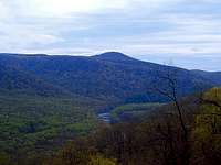
My hike to Middle Fork Overlook was pretty level, just a leisurely walk atop the Laurel Ridge in a developing mist. I was there in a bit more than an hour, and it greeted me with a surprising sight. The forest below the overlook shined some color my way as if it were preparing for autumn. Red maples all across the valley had their spring flowers in bloom, and it added some of that red to what would have otherwise been a sterile late winter canopy. Despite the descending clouds, I could still see fairly well to Chestnut Ridge in the west as I rested and snacked. Before turning around, I explored the boulders going down the hill below the overlook and found a small souvenir rock to keep.
Middle Fork Overlook along the Laurel Highlands Hiking Trail in Pennsylvania.
Rocky area near start of Laurel Highlands Hiking Trail.
Dense lowlands a few miles from the southern terminus.
A light rain evolved from the mist during my return hike. But even without the deciduous leaf canopy in place to shield me, the precipitation never really succeeded to get me wet. It also failed to dissuade other hikers in the area; I passed a couple of decent groups on my way back. Once I was back at the rental car, I had a pretty clear itinerary in my mind to visit the Youghiogheny River Gorge several miles southwest through the highlands. I shook off a sampling of mud and visited the gorge for the first time.
The Youghiogheny River cuts through Laurel Ridge dramatically and energetically. This area of Ohiopyle State Park is famous for whitewater rapids on the river. In addition to that water recreation, it also happens to be the southern terminus of the full seventy-mile Laurel Highlands Hiking Trail. I parked on the north rim of the gorge and quickly began undaunted by the wet skies. From this elevated parking area, my connecting trail to the Laurel Highlands pathway took me directly down the side of the gorge to the first mile of the main trail. Here I was nearly level with the river at about 1200' above sea level. But I began to climb back up the highlands as the trail took me northeast.
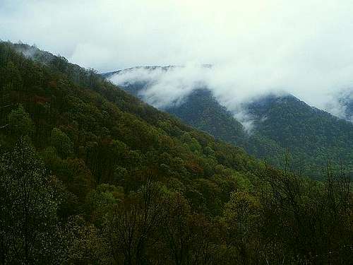
Inside the gorge, it was much rockier than I had found my section of interior highlands to be. It is always fulfilling for me to explore these kinds of areas, so I did not mind the rain and clouds in that regard. But the prevalent conditions prohibited any sort of good views or pictures from the overlooks promised throughout the first several miles of the trail map. The most distant location ahead that interested me - and also seemed feasible to reach today - was around the 7.5 mile mark. So I hatched a plan. I was going to press ahead vigorously through the rain to that point, and then make a more leisurely return hike in presumably better conditions. Like all my plans, this idea made me feel like a genius. I was high on energy and I charged through the first three miles. The first overlooks above the river flats were obscured by fog and accompanied by high winds, so I had little reason to stop now anyway. Once I started across the Rock Spring Run drainage, rain began to intensify, quite sufficient to get my clothes significantly wet. But it was just rain, not anything meaningful enough to dampen my enjoyment of the hike. It happens. As Robert Plant once eloquently sang in metaphor, upon us all, a little rain must fall.
Most of my outbound views were reduced to adjacent rocks like this.
A clean view of Sugarloaf Knob after the rainy weather lifted.
The lower forests of the gorge and its bordering valleys were already in growing season, making these areas much greener than the upper highlands in April. I maintained the same general elevation within them until the sixth mile, when the trail headed directly east out of the gorge. In about a mile and a half, the trail climbed 1200' up the highlands. This stretch is where my vigor and energy flattened out. That is not to say I abandoned my destination; I did in fact reach the overlook after the seventh mile. But as I neared it, I was moving as a sloth would. A trail runner blazed past me around this point, and he silently dropped a bit of humility that I carried with me to the top. The wet boulders on the edge of the highland plateau looked like a very inviting place to sit when I reached them. This was my turnaround point, and yet the weather was still not accommodating my wishes. Views from here were simply eye-level observations of the heavy fog and incoming rain. At some point on the ascent, I had again crossed the threshold between the blooming forest canopies and the dormant ones. I looked forward to getting a picture of that transition, but instead I had to channel all my pleasure from an apple I unexpectedly found in my backpack next to my planned lunch. Sometimes, the small pleasures make the difference. There is nothing like bonus food when hunger abounds.
After hiking through the rain to a foggy turnaround point, skies started to clear on my inbound return.
Midway down the slope between the plateau and the Lick Run drainage, the sights of the valley finally appeared to my great satisfaction. There was a gap in the trees, and the fog had partially cleared, just enough to leave a really neat visual effect from nature. The condensed moisture on the upper ridge looked as if it were instead the billowing smoke of a forest fire. On adjacent slopes low enough to already foster leaves, the green oaks and hickories were gleaming. Better late than never, I was seeing my first truly memorable view of what Pennsylvania has to offer. Another mile later, I could see down to the gushing river and the ribbon it formed through the otherwise unbroken forest.
After another sojourn through the lively valleys and brimming streams of Lick Run and Rock Spring Run, I followed the trail back up the north side of the gorge for the most open view on the trail. Perched high above a scenic bend in the river was an exposed rock overhang. It yielded an unobstructed view of the gorge, the river, and an area of drenched lowland flats bounded by the semi-circular river bend. I took in this sight over an extended break before my descent toward the trailhead and final deliberate ascent back to the off-trail parking area.
Clouds reach down into the Laurel Highlands.
The Youghiogheny River twisting through its namesake gorge.
The sun faded west of me before I exited Pennsylvania, and I settled in for a long shift of night driving. While the car moved and my body gradually stiffened, I remained awake and alert enough to finish my trip back in my own bed, not quite two hours in advance of my Monday morning alarm. It had nearly been a full calendar day since I awoke at my highland campsite, almost entirely comprised of movement in one way or another. My day’s activity entailed 21 miles hiking and 550 miles driving. All the body soreness and stiffness was only temporary; I was satisfied to make the absolute most of my weekend.
Parents refers to a larger category under which an object falls. For example, theAconcagua mountain page has the 'Aconcagua Group' and the 'Seven Summits' asparents and is a parent itself to many routes, photos, and Trip Reports.