
|
|
Route |
|---|---|
|
|
56.54212°N / 4.25325°W |
|
|
Hiking, Mountaineering, Skiing |
|
|
Spring, Summer, Fall, Winter |
|
|
Half a day |
|
|
Easy/Moderate |
|
|
Overview
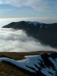
 On the descent down to Coie Odhair
 Meall nan Tarmachan from the summit
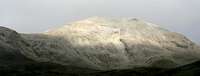 Corranaich from the path through Coire Ohair
Meall Corranaich is located in Glen Lyon, Scotland just to the north east of the beautiful town of Killin. Glen Lyon is a fairly isolated valley stretching for over 40km that contains many fine peaks. The most famous of these peaks is arguably Ben Lawers which sits directly east of Meall Corranaich. Lawers standing at 3983ft is the 10th highest peak in Scotland, which draws the vast number of hikers/climbers to the area. Meall Corranaich and Meall a'Choire Leith are the western hills of the Lawers range and form a fairly continous ridge that runs from south to north.
Meall Corranaich, as with 99.9% of Scottish hill names, derives fro the Gaelic language. There are a few possibilities to the meaning of this peak, these being Hill of the Sickle, Notched Hill or Hill of Lamenting. No certain name sometimes happens due to the fact that Gaelic can have one word for several different things. It could also have occured when the original translation was inaccurately written down by English speaking Ordnance Survey mapmakers in the mid 19th century.
Meall Corranaich stands at a height of 1069m/3507ft and is No.68 on the list of Scottish Munro tables. This peak can be combined with numerous other peaks in the Lawers range, but is most commonly done in conjunction with Meall a'Choie Leith.
For the purposes of this page though, the route described is for a direct ascent/descent of Corranaich from the National Trust for Scotland's visitor centre, which offers a quick day due to the height of the starting point.
Approx time taken: 4 hours
Getting There
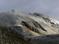
 Corranaich from Beinn Ghlas
From Glasgow take the A82 road to Crianlarich, turn right onto the A85 and continue along this road until turning left onto the A827 signposted Killin. Travel through Killin until taking the left turn signposted Ben Lawers visitor centre.
From Stirling take the A84 and follow until it becomes the A85 at Lochearnhead. Continue along this road until reaching the right hand turn for the A827 Killin.
Route
 Ben Lawers from the sumit.
From the car park at the Ben Lawers Visitor Centre pass through the gate(just left of the visitor centre) and follow the well defined path that heads north east. The path at the start is layed slats of wood(like traintracks) as you cross over marshy ground that leads to the double pass through gates that takes you onto the hillside proper.
The path crosses over the Burn of Edramucky in a brief easterly direction. Then we cross back again and a little further up back over again. From here a further height gain of 75m will give you the option of crossing the burn on your left and heading for the southern ridge of Meall Corranaich. For this route though, we will continue along the main path until reaching the fork at the 660m mark.
The well trodden path that heads right is the route of ascent for Beinn Ghlas and Ben Lawers and is the most used route within the range. We however, are taking the path to the left. The path is a good oneand rises gradually up through Coire Odhair until reaching a group of boulders that is located south east of Meall Corranaich.
From the boulders at the top of Coire Odhair head north west along the path for around 300 yards where the path starts to steepen considerably. The path is quite exposed at points but causes no real problems, although care should be taken in winter conditions. This section doesn't last very long and eventually you'll find yourself sitting on the summit taking in the views of Glen Lyon.
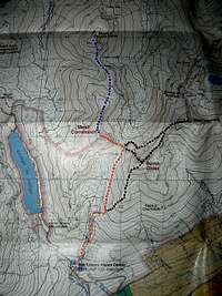
The attached map gives the main route described in red. I have also attached optional additional peaks and/or routes of ascent/descent in blue and black.
Maps & Books
 Contemplation near the summit
Landranger map 51.
OS Explorer map 378.
Harvey Superwalker map-Ben Lawers.
The Munro's book by Cameron McNeish, page 37.
The Southern Highlands by D.J. Bennet, page 175/176.
Southern Highlands (pocket mountains) by Nick Williams, page 12/13.
Essential Gear
Summer conditions: Backpack, walking boots/trainers, hat, gloves, water, food, waterproofs(your in Scotland you can bet it is going to rain at some point), map, compass, first aid kit, penknife, spare socks, walking poles can be good to ease the jarring on the old knees and your camera.Winter conditions: All of the above and ice axe, crampons, helmet and rope.
Ski Mountaineering
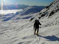
As one of the earliest ranges to draw ski mountaineers, the Lawers range offers wide and varied opportunities for ski mountaineering in the southern highlands. it is probably one of the best in the entire highlands due to the smooth slopes and broad ridges that the peaks offer.
On Meall Corranaich itself the south ridge is ideal for this and the traverse of Beinn Ghlas and Ben Lawers is known as the classic within the area.