
|
|
Route |
|---|---|
|
|
35.65420°N / 83.4369°W |
|
|
Hike |
|
|
Most of a day |
|
|
Walk-up |
|
|
Approach
From Gatlinburg, go south on Cherokee Orchard Road. Start at Rainbow Falls Trailhead off Cherokee Orchard Road.Route Description
Follow Rainbow Falls Trail for 6.0 miles to intersection of Bull Head Trail. Follow Bull Head West past lodge and shelter. Go about 0.2 miles past shelter. When you are at what seems to be the hights point, look south. 10 yards South of trail is rock pile at summit. Rumor is that the tradition is to place a rock on the pile when you summit to one day make Leconte higher than Clingmans Dome.Check out these pics of Rainbow Falls. It is a pretty impressive sight.
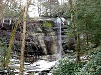 Rainbow Falls
Descend same route, Trillium Gap or Bull Head Trail back to trail head.
This trailhead is at 2560'. With the summit at 6593', this is a bretty big day by Eastern US standards. 4033' of elevation gain is more than many of the Colorado 14ers!
 Trail Topo
General GSMNP Trail Map
Essential Gear
Day pack only is required. Trails can be icy in winter. Definitely take poles. Ranger mentioned some people use the hiker's slip on cleats/crampons.Don't forget your 10 essentials. This is a pretty big day with alot of elevation gain for a dayhike.