|
|
Route |
|---|---|
|
|
27.0952°S / 109.3673°W |
|
|
Hike |
|
|
Most of a day |
|
|
Class 1 |
|
|
Approach
The beginning of the trail can be hard to find, but it is easy to get to since you walk from Hanga Roa. From the west end of the International Airport, walk along the road closest to the coast. Make sure to visit the cave and cave paintings along the ocean at Ana Kai Tangata. Follow the road as it turns east and inland. After reaching the Forest Service sign, look for a road on the right (south). There is a green gate just up the road. The road goes past a watertank and becomes a trail. It can take a bit of searching to find the correct start of the trail, but once you find the trail, it will be easy to follow.Note: The route described takes you to the more interesting west summit, but apparently the east summit is slightly higher.

Route Description
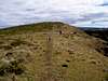
As mentioned, finding the correct start of the trail is the most difficult part of the climb. Once you find the correct trail, it is easy. From the Forest Service sign, find the road/trail that goes through a green gate and that climbs west of the water tank. The trail becomes easy to follow and is of a mostly gentle grade.You will pass through a nice fern and eucalyptus forest (with a nice lunch/rest spot) before reaching the open grasslands. There are some nice views of Hanga Roa from the grasslands. The trail will eventually reach the gravel road at the rim of the crater. Cross the road to the other side.
There is supposed to be a trail to the bottom of the crater lake, but since I didn’t know about it until after our hike, we missed it. Continue on the trail to the south and then southwest and along the up-and-down trail along the crater rim. There are some really nice views of the spectacular crater on one side and the ocean on the other all along the rim. The trail then meets the road again at the Ranger Station.
Make sure to pay your entrance fee here ($10) and follow either section of the loop trail south to the true summit and Birdman Cult ruins. See the history section on the main page for an explanation of what you are seeing. At the summit, there are excellent views of the ruins, the spectacular crater, and Motu Nui Island. You can continue to where the ridge drops off steeply and becomes a knife edge. Continuing along the knife edge and along the crater is no longer permitted, because of some accidents that occurred in the past, and because the route is considered to be unstable. Return via the other (the one you haven’t done already) loop trail to the ranger station and then reverse the ascent route.
The round trip distance is supposed to be 9 kms, or 6 miles, but this depends on where you start from in the town of Hanga Roa. With all there is to see, plan on taking most of a day for the trip.