
-
 13944 Hits
-
 77.25% Score
-
 8 Votes
|
|
Hut/Campground |
|---|---|
|
|
Cataluña |
|
|
Spring, Summer, Fall, Winter |
|
|
7283 ft / 2220 m |
Description
The mountain hut (Refugio) of Ventosa i Calvell is situated in the heart of the Catalan’s Aigüestortes National Park, in the Spanish province of Lleida. It is part of a network of 9 guarded huts, which form a famous alpine tour called “Carros de Fuego”. From its idyllic place at 2.220 meters over sea level, on the edge of a rocky promenade over the ‘Estany Negre’ (The Black Lake), offers a good starting point for some of the 3000ers of the area, and for some other interesting peaks of the park.The hut has beds for 70 people. There are pillows and blankets, but a sleeping sheet is needed. It has WC and shower (not always in use). It offers food and drinks to its guests. It has telephone connection and radio. There is a very good winter area (always open) with place for 8 people ( with blankets) and emergency telephone. The hut has no lockers, neither a place to leave the backpacks. There are rubber shoes at the entrance to be used by guests.
It is open from June till the third week of September. It also opens in February for the skiing season, as well as in Easter and in some other mayor Spanish holidays.
The facility belongs to the Cataluña’s federation of the Mountain Sport (FEEC).
Access
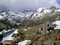 The hut stands over Estany Negre
The ‘Refugio de Ventosa i Calvell’, is reached in two and a half hours over a mountain path that starts at the ‘Embalse de Cavallers’ (1.785 m), 4 km from Caldes de Boí. From the parking next to the dam, the road continues to the right side of the dam, where the walking path starts along the right side of the water (northern bearing). This part of the path can be dangerous in winter when a steep slope of (hard) snow falls towards the icy dam’s shore. There are, at least, two points on this part of the path, with avalanche risk. Passed the dam, the track rises to the grassy plains of Riumalo (1.890 m), where the path continues next to the left bank of the river (walking with the river to the left). A wooden bridge crosses the riverbed and a steep walk among granite rocks and walls starts (Barranc Llastres). Once up, the terrain levels again and there is a clear view over the ‘Estany Negre’ (Black Lake) to the right, some meters down the valley. The walk continues on eastern direction along the north side of the lake for about 15 minutes till the hut is seen over a big granite promenade.
Possible ascends and treks from the hut
Pico de Contraix (2.958 m) 800 m 3,30 hrsPa de Sucre (2.862 m) 650 m 4 hrs
Tumenèja (2.783 m) 570 m 4 hrs
Besiberri Norte (3.015 m) 800 m 4 hrs
Montardo (2.833 m) 613 m 3 hrs
Punta Alta (3.014 m) 794 m 3,30 hrs
There are many climbing walls in the neighbourhood:
Aguilles de Travessani (2.659 m)
Pa de Sucre (2.862 m)
Pics de Comalespada (2.833 & 2.831 m)
There are walking paths to the following huts:
Ref. de Restanca (over the Crestada saddle)
Ref. de Colomèrs (over Pass of Colomèrs or Pass of Caldes)
Ref. de Estany Llong (over the Collet de Contraix)
Contact
The telephone number of the hut is:+34 973 641809 (phone and fax)
+34 973 297090 (hut’s phone)
The guard of the hut is Miguel Sánchez
There is a webpage as well: www.refugiventosa.com