
-
 5688 Hits
-
 71.06% Score
-
 1 Votes
|
|
Route |
|---|---|
|
|
46.68600°N / 13.14670°E |
|
|
Mountaineering, Scrambling |
|
|
Summer, Fall |
|
|
Half a day |
|
|
Walk-up |
|
|
Approach
The approach starts on the saddle between Jochalm and Reisskofel, on the altitude of 1492 m. See the parent page how to get there!
Route Description
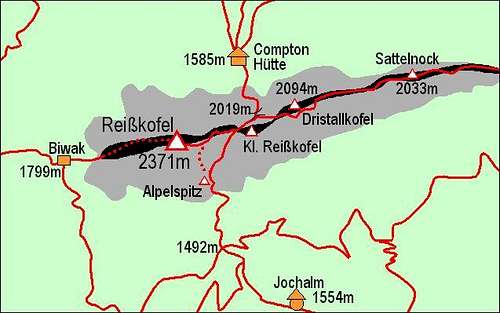
Reisskofel and its routes
In many turns the marked path goes up through woods, keeping slightly towards the right. When it reaches open landscape it ascends over quite steep grassy slopes, till it reaches the remarkable Alpelspitz, 1959 m. After a slight descent over the shallow ravine to the right, we reach the crossroads.
For experienced the direct approach to the ridge is recommendable. If we chose it, we turn left, and the path starts ascending very steeply over grassy slopes. Some 100 m higher the path crosses an unpleasant ravine and is still not protected. Above it, grassy slopes are even more steep. We face almost a 'climbing section' over grassy slopes. Foot steps are good and deep, but in wet the path would require much care. Above this part we reach rocky slopes (climbing detail of UIAA I) and there the route is also secured with steel ropes. We already see the summit ridge, some 100 m more and we reach it. Over the summit ridge we go towards the left (westwards), descend from the fore-summit to a nearby notch and over the final part of the ridge we climb up to the summit.
If the direct south route is too steep for a descent, we descend by the not much easier east ridge all the way down to the notch below Kleines Reisskofel. Here one path goes down the northern slopes towards the Compton hut, the second one ascends Kleines Reisskofel and our path goes down over the southern slopes. We turn right and cross far back, losing only a little altitute, until reaching Alpelspitz. Although this route is easier than the direct one, it still requires quite some care, especially when rocks are wet.
Essential Gear
Good shoes, poles.
Rating the route (by hiking standards)
0. General: 1492 m to 2371 m, exposition S, marked, partially protected route over grassy and rocky slopes. Overall difficulty on the Swiss Hiking Scale: T4.
1. Effort: 900 m, 2 h 15 min.
2. Power: 2 - easy.
3. Psyche: 4 - moderate (depth rising, quite some care needed if wet).
4. Orientation: 1 - no difficulties.