Foreword.
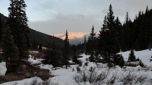
It seems as though Winter of 2012 never came. Here in Colorado's Front Range we had an extended Fall season, followed by a spattering of depth hoar, and an inconsequential snow accumulation that wanted nothing more than to break, slide, and bury the unwary back country traveler. Unfortunately, "good" Winter conditions in the alpine never came, and a year's worth of goals will be shelved until next season. Such is the bane of many back country enthusiasts in the great state of Colorado. However, with the passing of the short Winter season, the rock has bared, the snow has hardened, and many have already thrown away the encumbrances of skis and snow shoes. Couloir season has already begun in late March and through the rapidly depleting snow pack alpine rock season promises to be not far behind. Enter The Citadel's North Ridge.
The traverse from Pettingell Peak to the Citadel is an all day alpine adventure of ridge line scrambling and technical rock climbing. Our gear selection for the traverse was fairly conservative: ice axe, crampons, helmet, 30m 8mm rope, four C4's to #1, four mid sized hexes, stoppers, a cordelette, and 6 alpine draws. Beta photos indicated there were several opportunites for protection on the technical buttress and we were prepared to climb 50 to 100 feet of mid 5th rock. When selecting this destination our hope was that the technical climbing would be dry and the early season snow would add flavor to an already spicy ridge traverse. We were not disappointed.
Pettingell's East Ridge
Beginning at the Herman Gulch Trailhead at around 7:00 AM, we made quick progress up the switchbacks headed for Herman Lake. The trail was nearly completely dry until several miles into the hike where we encountered patchy snow that was well frozen and easily navigated. There were a few sections that were inconsolidated and involved short stretches of post holing, but for the most part it was fast, easy terrain.
![Patchy Trail]() Patchy Trail
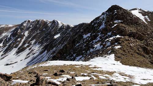
Patchy Trail![The Traverse]() The Traverse, From Afar
The Traverse, From Afar
Near 11,400 feet we grew tired of the warming, snow covered trail and headed straight up in an effort to break tree line and find better snow conditions on the ridge. Breaking tree line, we gained the East Ridge of Pettingell Peak and followed it to the summit. If climbing Pettingell Peak I highly recommend using this ridge as it avoids a lot of miserable talus slopes below, and the rock at the ridge crest is very solid and involves quite a bit of class 3 scrambling with opportunities for exposure.
![Breaking Tree Line]() Breaking Tree Line
Breaking Tree Line![Pettingell s East Ridge]() Pettingel's East Ridge
Pettingel's East Ridge![Solid Scrambling]() Solid Scrambling
Solid Scrambling![More Class 3]() More Class 3
More Class 3
The East Ridge itself is long, but eventually empties onto the summit ridge of Pettingell Peak. We enjoyed excellent weather this day and indulged in a long 45 minute break in the light breeze and 50 degree F temps on the summit.
![Pettingell Summit Ridge]() Pettingell Summit Ridge
Pettingell Summit Ridge![Perfect Day]() Perfect Day
Perfect DayTraverse to The Citadel
To traverse to the Citadel, we headed south-west to Point 13,418 where we had an excellent and daunting view of the traverse. From here the terrain to the south and west drops off sharply, but take heed, there is over a half mile of class 2 terrain before any difficulties on the ridge. After descending to just below 13,000 feet the ridge narrowed and several small gendarmes presented themselves. These can be skirted or climbed to add more scrambling value to the route. In between the gendarmes we encountered a few mellow snow ridges, several of which beckoned the use of an ice axe. Our crampons, however, stayed in our packs for the entirety of the day.
![Traverse From Pettingell]() Traverse From Pettingell
Traverse From Pettingell![Snow Traverse]() Snow Traverse
Snow Traverse![Snow Ridge]() Snow Ridge
Snow Ridge![Gendarmes]() Gendarmes
Gendarmes
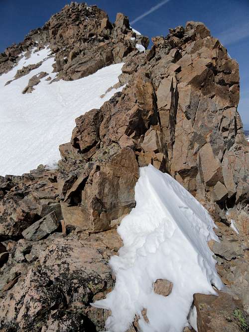
The crux of the route is in view for the majority of the traverse, and as it loomed closer our excitement grew and grew, to a point where we were ready to be done with the scrambling and out on the buttress! After a final, sharp gendarme, we stepped into the shadow cast by the 150 foot buttress. Our warm, sunny day instantly turned cold and damp and a frigid wind blew up from the abysmal couloirs that sliced the rock we were standing above into a jagged, ethereal blade. It's time to rack up.
![The Crux]() The Crux
The Crux![Exposure at Belay]() Exposure at First Belay
Exposure at First BelayThe Technical Bit
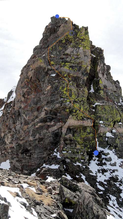
![Buttress Topo]() Route Topo
Route Topo
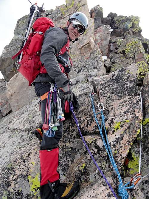
Shivering from the cold, we added layers and made a hasty inspection of the chimney at right and buttress at left. The rock in the chimney was dark, slick, and rotten, and any protection placed in it seemed to be tenuous and unreliable at best. Half way up, drifts of snow promised to circumvent any positive foot or hand holds. The buttress was well guarded at its lower reaches by an overhang and some loose blocks on the left with the east side dropping away precipitously. A less obvious traverse from the chimney on the right ultimately provided access to the face above. The face itself was mostly loose, with several sections of pink granite that provided the only protection on the route. We first attempted a direct route at the base of the left side, but after pulling three large rocks in the first few moves decided that the rock was too unreliable to trust when pulling the overhang. We backed off and changed our strategy. Atop our belay platform at the base of the chimney, we slung a precarious looking flake and set off. Near 15 feet off the ground the crux of the route presents itself: transitioning from the chimney through the overhang and onto a ledge on the buttress. This was well protected with a cam just overhead in between two large granite blocks. After pulling the overhang, we removed the cam and ran it out over 30 feet of easy, loose climbing until plugging in a bomber hex in a flaring crack. "So much for stitching it up," I thought. Not much longer I passed some rappel anchors on the left and stretched the rope out to a good belay stance at the base of a sharp arete.
![Second Belay]() Second Belay
Second Belay![Final Belay]() Final Belay
Final Belay
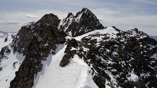
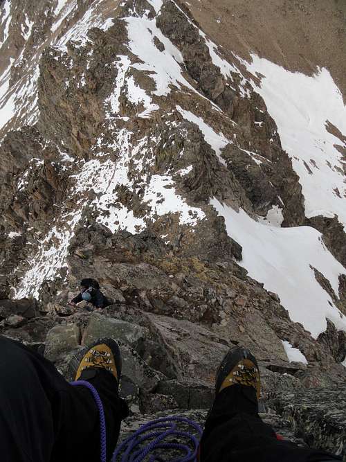
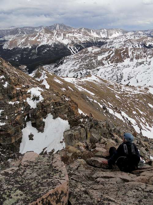
As Scott climbed and reached the belay, he remarked that he may have gotten in over his head. After demostrating the integrity of the belay anchor he felt a little better. The next pitch offered less than 50 feet of climbing up a really fun arete and chimney system to a slung rappel anchor to belay from. This was a memorable belay, sitting on a small ledge with a back rest, feet hanging out over a thousand feet of air to the valley floor, with a view of the second coming up. The chimney was quite loose and while following, Scott dislodged a couple good sized blocks that went sailing all the way to the ground. Above this we were back on scrambling terrain, but remained roped up on a running belay for safety. The rest of the climb went too quickly, and soon we were standing on opposing blocks on the west summit of The Citadel (13,294 feet).
![Exposed Snow]() Exposed Snow
Exposed Snow![Summit Ridge]() Summit Ridge
Summit Ridge![Citadel Summit]() Citadel Summit
Citadel SummitMount Bethel's Revenge
After some summit revelry we packed up the gear and stripped a few layers as we were now back in the sun and the wind had died. We made the quick scramble into the notch, which was complicated by very little and rotten snow and continued to contour below the south face of The Citadel. We soon had linked up with the East Ridge and began our descent. The ridge from this point on was undulating and if it were not for the slushy snow conditions in Herman Gulch we would have dropped immediately down a glissadable slope. What ensued can be affectionately referred to as "Mount Bethel's Revenge." We slogged over the many ups and downs along the ridge, finally dropping back into Herman Gulch at the saddle before the final slope up to Mount Bethel's summit.
![Notch Bound]() Notch Bound
Notch Bound![South Face Traverse]() South Face Traverse
South Face Traverse![Mount Bethel s Revenge]() Mount Bethel's Revenge
Mount Bethel's Revenge![Couloir Beta]() Couloir Beta
Couloir Beta
We caught a few good glissades on the way down before ultimately descending into the post holing nightmare that is Spring snow after a hot day. After an immeasurable amount of pain and suffering we finally made it to the stream, where we enjoyed punching through the ice into calf deep water before hitting the somewhat consolidated trail. Here we enjoyed (you guessed it!) more post holing until the sun dropped below the horizon and we made it back to dry trail. Stumbling down the trail, we shared similar opinions about the fit and comfort of our LaSportiva mountaineering boots at the end of a long day and managed to somehow make it down in the dark without stopping to put on our headlamps. The sound of Interstate 70 has never been so welcome. END.
![Glissades]() Glissades
Glissades![Death March]() Death March
Death MarchNumbers and Stuff
RT Length: ~10 miles
Elevation Gained: ~4000 feet
Climbing Style: Moderate snow, 5.4 rock
Car to Car: 13 hours


Comments
Post a Comment