
-
 4628 Hits
-
 75.81% Score
-
 6 Votes
|
|
Route |
|---|---|
|
|
46.83028°N / 10.45719°E |
|
|
Hiking, Scrambling, Skiing |
|
|
Summer, Fall, Winter |
|
|
Half a day |
|
|
Hike and Scramble |
|
|
Overview
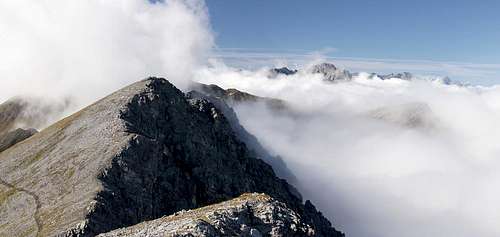
 The ridge towards Piz Lad as seen from Äußerer Nockenkopf The ridge towards Piz Lad as seen from Äußerer Nockenkopf |
The ridge traverse from Piz Lad to Piz Rusenna / Jochboodenkopf and Äusserer Nockenkopf is the most scenic route to these mountains. It requires getting up to Piz Lad in the first place, which is most easily achieved by the normal route from Reschner Alm. There is a second route running to Grubenjoch Saddle but this cuts short the most beautiful part of the traverse, the south-west ridge of Piz Lad itself.
The route is a hike in character, only the decent into and ascent out of Grubenjoch Saddle could be described as scramble. If Piz Nair - which stands a little apart from the ridge - is included in the traverse, you'll be in for UIAA II-III climbing. Usually, however, Piz Nair is passed by, mainly because of the difficulty involved and because it is the lowest mountain on the whole ridge.
Getting There
See the Piz Lad and Piz Rusenna pages for the information of how to get to the village of Reschen. From there proceed as follows:
- In the upper part of the village (direction Reschenpass) there is a marked road leading to the Schöneben Ski Lift.
- Follow this road to the western shore of the lake
- Pass the ski lift heading for the hamlet of Rojen
- After several switchbacks the road levels and here a sign directs you to the right to Reschner Alm.
- Follow the dirt road for some 5km. It is very narrow in several places.
Route Description
- Start altitude: 2808m- Summit altitude: 2808m
- Prevailing exposure: E
- Type: Hike
- Protection: None
Don't be fooled by the 300m elevation gain - the route starts at its highpoint, which can be reached only by a hike, gaining 800m - 1000m! It follows the normal route to Piz Lad, which ends at the summit cross, several metres below the real summit.
 Piz Lad real summit
From the summit cross follow Piz Lad's south-west ridge to the real summit, from where you have a good overview of what is to come. Several smaller cols interrupt the ridge and in its south-western part the marked trail avoids it altogether, staying on its eastern side. However, the ridge can be climbed in a short scramble, which leaves the problem to leave it for the descent to Grubenjoch. Terrain here is tricky, brittle and steep until you regain the regular hiking trail. It also descends steeply into Grubenjoch with some fun sections,, which are neatly exposed.
 Piz Lad south-west ridge
After a few metres, however, the path leaves the ridge, turning eastward instead and heading towards a knobbly summit, from where you can return towards Reschner Alm. Here, route finding can become tricky. Don't follow the signs (which lead to the Alm) but rather follow the posts which mark the border between Switzerland and Italy. They turn southward again, leading in a steep scramble up some metres. On the next summit the border heads down directly into Grubenjoch through a steep couloir, while the path (oold marks only) heads down a less exposed rib which reaches the saddle a bit further east.
 Grubenjoch Saddle
From the saddle another steep scramble takes you up the east slopes of Piz Nair, which looks across the saddle like a sentinel. The path finally reaches the Jochboden pasture, an alpine high plateau which is responsible for Piz Rusenna's German name: Jochbodenkopf. Piz Nair can be reached from here: climb towards the north ridge of Piz Rusenna, hike to the base of Piz Rusenna and then head up the remaining 100m in a UIAA II - III scramble.
 Piz Nair
If you want to skip Piz Nair, cross the Jochboden meadow (no trails or paths here) towards a rib which comes down from Piz Rusenna (NE-ridge), where yoou can make out a path from afar already. It takes you through the Rusenna east face, avoiding the summit but joining its south ridge several hundred metres beyond. Turn back to Climb Piz Rusenna in an easy scramble.
 Jochboden Meadow
For Äußerer Nockenkopf / Dosso di Fuori, simply follow the ridge, which stays level for most of the time, except for the final metres. The summit cross - like the one on Piz Lad, is set eastwards a little so that it can be seen from the villages around Reschensee / Lago di Resia.
 Piz Rusenna Piz Rusenna | 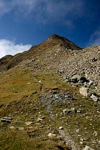 Piz Rusenna Piz Rusenna |  Äußerer Nockenkopf Äußerer Nockenkopf |