
|
|
Hut/Campground |
|---|---|
|
|
46.38130°N / 9.90670°E |
|
|
Spring, Summer, Fall, Winter |
|
|
9229 ft / 2813 m |
Overview
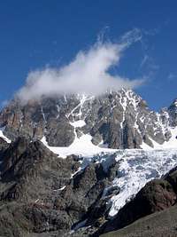
Marinelli-Bombardieri Rifugio lies on a large crag in upper Scerscen Valley, opposite the northern side of Cime di Musella on 2813m.It is the biggest refuge on the italian side of Bernina Group.
It is very popular because it's situated reachable altitude and you can choose many targets to go. You can find a list below about the nearest summits and huts.
You can reach the house easiestly from Campo Moro dam (1990m) and after 820m elevation in 3-4 hours walking on well-marked easy to follow trail or footpath. Requires suitable equipment and fitness level.
 |  |  |
When we was there (in end of June) only the winterroom was open . There is a little kitchen, a room for the wet clothes and shoes on the ground floor . Upststairs you can find a room for 14 persons. There are lots of covers.
There are heating facilities but we didn't find firewood and oil was ran out. At last we found a few firewoods but these were too large and we didn't find any axes to cut them smaller.
Getting There
Departure point: Rifugio Zoia, but you can leave just as well as from Lago di Campo Moro.Access:
The Campo Moro dam (1990 m) can be reached by turning left off the State Road 38 at the entrance to Sondrio to take the Val Malenco road following the signs to Lanada and Franscia, after which the road is unpaved (Milan- Sondrio 130 km; Sondrio - Franscia 24 km; Franscia - Campo Moro 9 km). From the parking lot at the height of the dam follow the dam wall and then go down by way of a small road to the wider part below. Cross this and you'll see the sign for the Carate and Marinelli-Bombardieri mountain huts. Follow this trail which ascends the slopes above to take you to a wooded knoll with a scenic view. Now go northwest over a gentle incline then over level ground to go around the southwest outshoot of Sasso Moro. Around 2200 m of elevation (on the left there is a trail that goes up to the Musella Alps) in the large valley between Mount Forbici and Sasso Nero the slope becomes steep again. Follow along a somewhat monotonous path to the Carate mountain hut and the narrow Forbici Pass (2 hrs). After the pass descend to halfway down the slope and head north over loose rocky debris and near the northwest offshoot of the western ridge of the eastern side of Cima di Musella. The trail ascends towards the east passing the small glacial lake at the foot of the tiny Cime di Musella glacier. Cross the river that comes from the nearby Caspoggio glacier and go up towards the northwest to go right around the large rocky crag, on which, already easily visible, the mountain hut is located. You can get there over a last steep part full of curves.

Services
In season:Hot and cold water,
Elecricity (220V)
Heating,
 Winterroom
Toilettes,
Showers,
Restaurant,
Self cooking,
Alpine club discount (CAI).
Number of places: 220 in matrace space
Winter: 14 places in bed
Hut guard: of 01/04 to 31/05 and of 25/06 to 30/09
Close summits
Cima di Fellaria (3.080m, 2 hour)Cima di Musella (3.094m, 2 hour)
Sasso Moro (3.108m, 3 hour)
Cima di Caspoggio (3.136m, 2 hour)
Punta Marinelli (3.182m, 1'30 hours)
Sasso d'Entova (3.331m, 3'45 hour)
Pizzo Malenco (3.438m, 4'30 hour)
Piz Tremoggia (3.441m, 4'30 hour)
I Gemelli (m.3497),
La Sella (m.3584),
Piz Glüschaint (3.594m, 5'30 hour)
Piz Palü (3.905m, 5 hour
Piz Roseg (3.936m, 6 hour)
Piz d'Argient (m.3945),
Piz Scerscen (3.971m, 4 hours)
Piz Zupò (m.3995),
Piz Bernina (4.049m, 5 hour)
 Piz Roseg (3936m) Piz Roseg (3936m) |  Piz Scerscen (3971 m) Piz Scerscen (3971 m) |  Scarscen glacier Scarscen glacier |
Access:
Van Franscia: 4 hours.
Campo Moro: 4 hours.
Van Rifugio Carate-Brianza: 1 hour.
Van Lanzada: 7 hours.
Climbs:
To Punta Marinella 3182 m, along the Via Normale (normal route) of the eastern ridge. Route: From Marinelli-Bombardieri mountain hut (2813 m) go along the trail that, from the eastern side of the square, goes up along rocky debris and passes by the crags of Cresta del Rifugio. Go past a small meltoff river and turn left (north). Follow the path over big rocky steps to the detritus basin that precedes the eastern part of Marinelli Pass. Now turn right and ascend a snowy slope that takes you to the nearby snow mound which extends between 3333 m of elevation and Punta Marinelli. Here you'll find the eastern side of Marinelli Pass at 3120 m (30 min). From there, over an easy debris strewn ridge, you'll arrive at the summit (F; 1 hr).
 Signs at Marinelli - Bombardieri Rifugio
Traverse
To Entova Scerscen ex-mountain hut (F; 3 hrs) path over moraine and glacier. To Chamanna Coaz 2610 m (F; 5 hrs) over the upper Scerscen glacier and the small Sella glacier.
To Parravicini bivouac 3183 m over the glacier of upper Scerscen (F; 2 hrs).
To Marco e Rosa mountain hut 3597 m (PD; 2 hrs).
To Pansera bivouac 3546 m (F, 2 hrs) over the eastern part of the small Fellaria glacier.
To Bignami mountain hut 2385 m, over the narrow Caspoggio Pass (F; 2 hrs).
Route: From the mountain hut go down to the access trail to about 2700 m and then go left on a path that runs halfway down the mounainside to the Caspoggio glacier. Go up onto the glacier (crevasses are rare) heading southeast to the evident saddle of Caspoggio Pass (2983 m). You can get to the pass by crossing the generally easy bergschrund. Go down along a small gully (fixed rope) and what's left of a small snowfield. Then go over rocky ground (trailmarkers) on a trial through the large valley that takes you first to the Fellaria Alps and after to the mountain hut.
More infos
Phone:0342/511577.
Owner:
CAI Sezione Valtellinese Sondrio
Via Trieste 27 - Sondrio. Tel. 0342 -21.43.00
Manager:
Enrico Gianatti
Built in: 1880 converted 1986
Situated in Val di Scerscen
Val Malenco Map
This is the map of the Val Malenco region. (Sondrio - Franscia)
rgg - Jan 17, 2011 2:47 pm - Hasn't voted
The coordinates appear to be those of Piz BerninaAfter searching a bit, I found the hut at coordinates 46.3445 N, 9.9053 E.